MyTopo
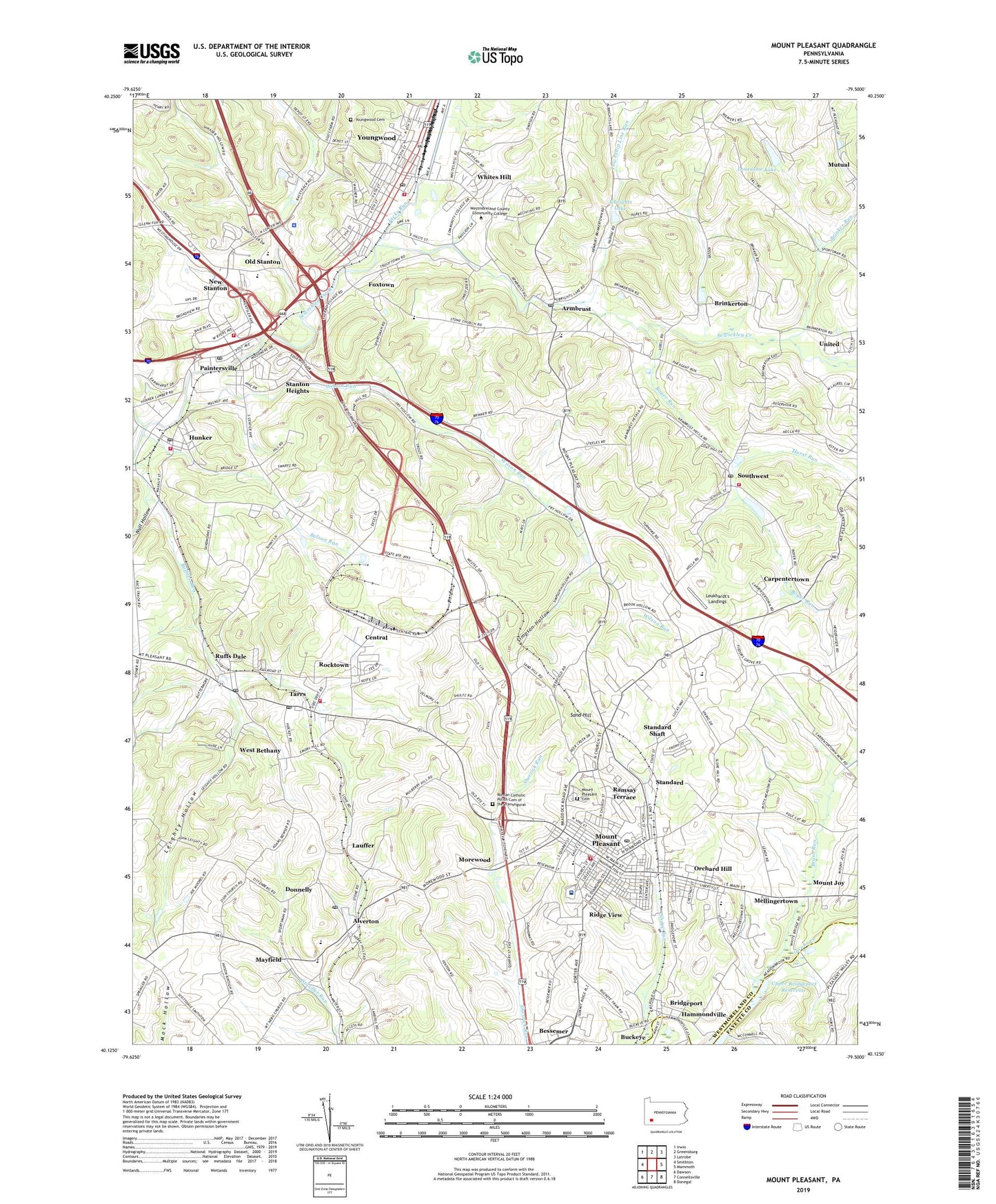
Mount Pleasant Pennsylvania US Topo Map
Couldn't load pickup availability
2023 topographic map quadrangle Mount Pleasant in the state of Pennsylvania. Scale: 1:24000. Based on the newly updated USGS 7.5' US Topo map series, this map is in the following counties: Westmoreland, Fayette. The map contains contour data, water features, and other items you are used to seeing on USGS maps, but also has updated roads and other features. This is the next generation of topographic maps. Printed on high-quality waterproof paper with UV fade-resistant inks.
Quads adjacent to this one:
West: Smithton
Northwest: Irwin
North: Greensburg
Northeast: Latrobe
East: Mammoth
Southeast: Donegal
South: Connellsville
Southwest: Dawson
This map covers the same area as the classic USGS quad with code o40079b5.
Contains the following named places: Albrights Lake, Alice, Alliance Church, Alverton, Alverton Post Office, Alverton School, Armbrust, Armbrust Post Office, Auberle Girls Semi Independent Home, Belson Run, Bessemer, Borough of Hunker, Borough of Mount Pleasant, Borough of New Stanton, Borough of Youngwood, Boyer Run, Bridgeport, Brinker Run, Brinkerton, Brinkerton Dam, Brumbaugh School, Brush Run, Calvary Baptist Church, Carpentertown, Central, Central Westmoreland Area Vocational-Technical School, Donnelly, East Huntingdon Township Volunteer Fire Department, Excela Health Frick Hospital, Foxtown, Hecla Volunteer Fire Department, Hunker, Hunker Post Office, Hunker Volunteer Fire Department, Hurst Run, Jacks Run, Lauffer, Leighty Hollow, Leukhardt's Landings, Lonesome Lake, Mayfield, Mellingertown, Middle Church, Morewood, Mount Joy, Mount Lebanon Church, Mount Pleasant, Mount Pleasant Area Junior Senior High School, Mount Pleasant Borough Police Department, Mount Pleasant Cemetery, Mount Pleasant Emergency Medical Services Medic 10, Mount Pleasant Free Public Library Association, Mount Pleasant Post Office, Mount Pleasant Volunteer Fire Department, Mulberry Hill Golf Course, Mutual Aid Ambulance Service East Huntingdon, Mutual Aid Ambulance Service New Stanton, New Stanton, New Stanton Church, New Stanton Post Office, New Stanton Volunteer Fire Department, Null Hollow, Old Stanton, Orchard Hill, Paintersville, Pensylvania State Police Troop T New Stanton Station, Polish High School, Ramsay High School, Ramsay Terrace, Ridge View, Robert Shaw Acres, Rocktown, Roman Catholic Polish Cemetery of the Transfiguration, Ruffs Dale, Ruffs Dale Post Office, Ruffsdale Elementary School, Rumbaugh School, Saint Gilbert Church, Saint Johns Union Church, Saint Josephs School, Sand Hill, Sewickley Church, Shupe Run, Simpson Hollow, Snydertown, Southmoreland High School, Southwest, Southwest Post Office, Standard, Standard Shaft, Stanton Heights, Stanwood School, Tarrs, Tarrs Post Office, Township Line Run, Township of East Huntingdon, Upper Bridgeport Dam, Upper Bridgeport Reservoir, Valley Community Services, Weavers Old Stand, West Bethany, Westmoreland Community College, Whites Hill, Wilson Run, Youngwood, Youngwood Area Public Library, Youngwood Baptist School, Youngwood Cemetery, Youngwood Park, Youngwood Post Office, Youngwood Volunteer Hose Company 1, Zions Church, ZIP Codes: 15612, 15616, 15639, 15666, 15672, 15688, 15697