MyTopo
Freeport Pennsylvania US Topo Map
Couldn't load pickup availability
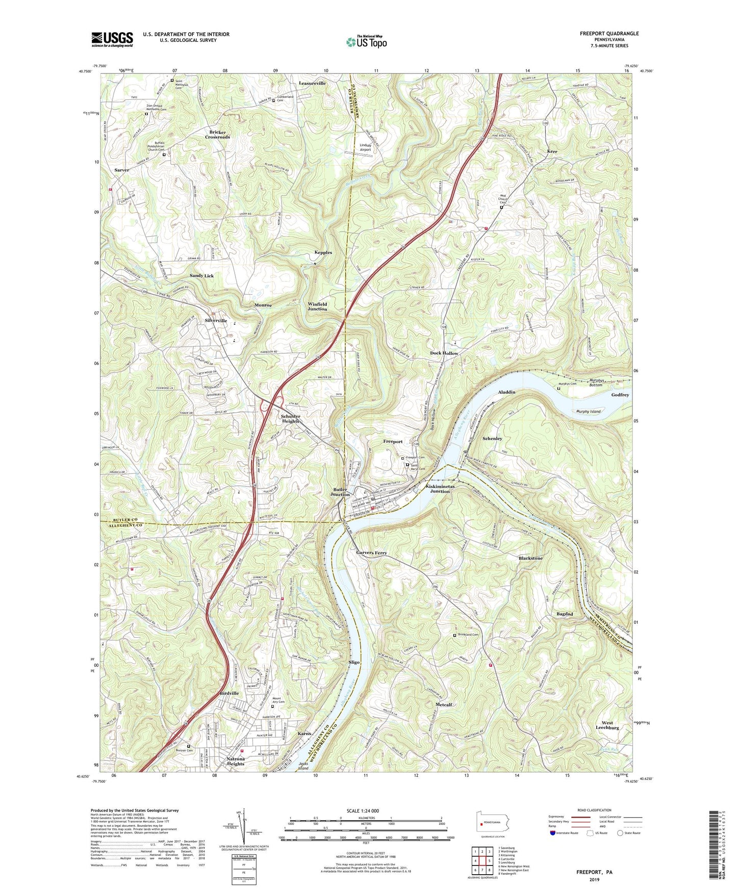
2019 topographic map quadrangle Freeport in the state of Pennsylvania. Scale: 1:24000. Based on the newly updated USGS 7.5' US Topo map series, this map is in the following counties: Armstrong, Butler, Westmoreland, Allegheny. The map contains contour data, water features, and other items you are used to seeing on USGS maps, but also has updated roads and other features. This is the next generation of topographic maps. Printed on high-quality waterproof paper with UV fade-resistant inks.
Quads adjacent to this one:
West: Curtisville
Northwest: Saxonburg
North: Worthington
Northeast: Kittanning
East: Leechburg
Southeast: Vandergrift
South: New Kensington East
Southwest: New Kensington West
Contains the following named places: Aladdin, Allegheny Church, Allegheny River Lock and Dam Five, Allegheny River Pool Five, Allegheny Township Volunteer Fire Station, Bagdad, Bagdad School, Bibleway Lighthouse Fellowship Chapel, Big Run, Birdville, Birdville Elementary School, Blackstone, Borough of Freeport, Brackenridge Golf Course, Bricker Crossroads, Brookland Cemetery, Buffalo Creek, Buffalo Golf Course, Buffalo Presbyterian Church Cemetery, Buffalo Township Police Department, Buffalo Township Volunteer Fire Department Station 27, Buffalo United Pesbyterian Church, Burtner Cemetery, Butler Junction, Camp Piney Nook, Center Church, Citizens Hose Volunteer Fire Department 2 Station 167, Cumberland Cemetery, Dock Hollow, Donley, Elder Run, Evangel Heights Assembly of God, Expressway Baptist Church, Fawn Elementary School, Fawn Township Volunteer Fire Company 2 Station 151, Freeport, Freeport Area Senior High School, Freeport Borough Police Department, Freeport Cemetery, Freeport Junction Station, Freeport Police Department, Freeport Post Office, Freeport Public Library, Freeport Volunteer Fire Department Station 70, Garvers Ferry, Glencairn, Godfrey, Harbison, Harrison Hills County Park, Harrison Hills Volunteer Fire Company Station 169, Harrison Township Census Designated Place, Heineman Airport, Highlands Industrial Park, Ingleside Post Office, Iron Bridge, Karns, Kepples, Kerr, Kingdom Hall Church, Kiskiminetas Junction, Kiskiminetas River, Knapp Run, Knapps Hill, Laneville, Laube Golf Course, Leasureville, Lindsay Airport, Little Buffalo Creek, Lucesco Post Office, McKean, Monroe, Mount Airy Cemetery, Mount Hope Church, Mud Church Cemetery, Murphy Island, Murphys Bottom, Murphys Cemetery, Nolf Corners, Pine Run, Rachel Carson Run, Ralston School, River Forest Golf Course, Saint Marys Cemetery, Saint Matthew Church, Saint Matthews Cemetery, Sandy Lick, Sarver, Sarver Run, Schenley, Schenley Post Office, Schrader Crossroads, Schuster Heights, Shrader Grove Church, Silverville, Sligo, Sloan School, Snider Airport, South Buffalo Township Police Department, South Buffalo Township Volunteer Fire Department Fire Station 220, The Church of Jesus Christ of Latter Day Saints, Township of Buffalo, Township of Harrison, Township of South Buffalo, Transylvania Bible School, Van Dykes, Walker Station, Wesleyan Methodist Church, Winfield Junction, Zion United Methodist Cemetery, Zions Church, ZIP Codes: 15065, 15656, 16055, 16229