MyTopo
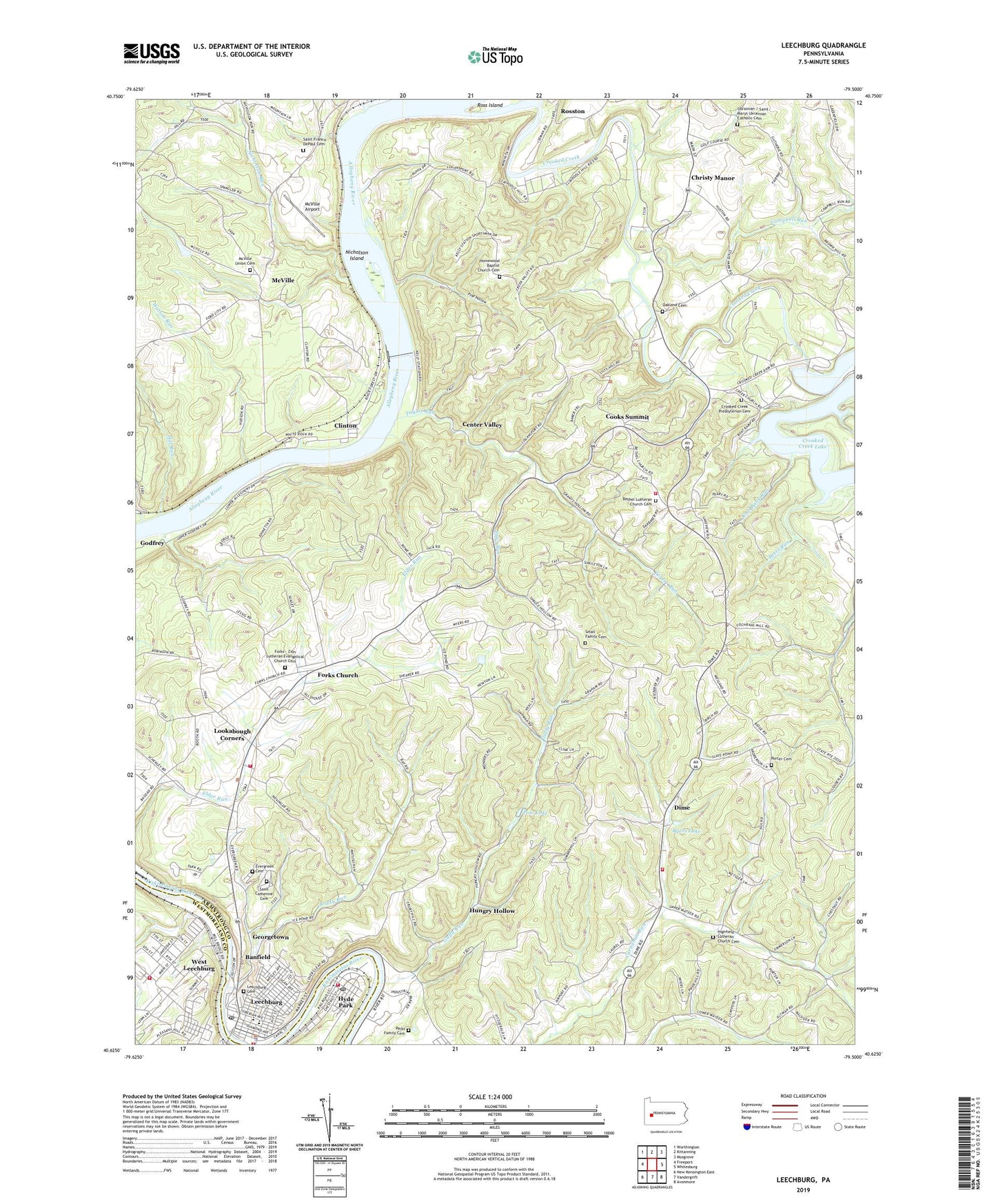
Leechburg Pennsylvania US Topo Map
Couldn't load pickup availability
2023 topographic map quadrangle Leechburg in the state of Pennsylvania. Scale: 1:24000. Based on the newly updated USGS 7.5' US Topo map series, this map is in the following counties: Armstrong, Westmoreland. The map contains contour data, water features, and other items you are used to seeing on USGS maps, but also has updated roads and other features. This is the next generation of topographic maps. Printed on high-quality waterproof paper with UV fade-resistant inks.
Quads adjacent to this one:
West: Freeport
Northwest: Worthington
North: Kittanning
Northeast: Mosgrove
East: Whitesburg
Southeast: Avonmore
South: Vandergrift
Southwest: New Kensington East
This map covers the same area as the classic USGS quad with code o40079f5.
Contains the following named places: Allegheny River Lock and Dam Six, Allegheny River Pool Six, Banfield, Beers Run, Bethel Church, Bethel Lutheran Church Cemetery, Bethel Township School, Bethel Township Volunteer Fire Department Station 270, Borough of Hyde Park, Borough of Leechburg, Borough of West Leechburg, Brady Run, Byers Lake, Cabin Greens Golf Course, Campbell Run, Center Valley, Christy Manor, Clinton, Coal Bank Run, Cooks Summit, Crooked Creek, Crooked Creek Church, Crooked Creek Dam, Crooked Creek Presbyterian Cemetery, Crooked Creek State Park, Dime, Dime Post Office, Evergreen Cemetery, Fireman Recreation Hall, Forks - Zion Lutheran Evangelical Church Cemetery, Forks Church, Georgetown, Gilpin Elementary School, Gilpin Township Police Department, Gilpin Township Volunteer Fire Department Station 100, Glen, Grace Church, Guffy Run, Highfield Lutheran Church Cemetery, Hill Run, Hills Consolidated School, Homewood Baptist Church Cemetery, Homewood Church, Hungry Hollow, Hyde Park, Hyde Park Post Office, Hyde Park Volunteer Fire Station, Johnetta, Kelly Station, Kikkatuck Airport, Laurel Point School, Leechburg, Leechburg Airport, Leechburg Area Elementary School, Leechburg Area Junior / Senior High School, Leechburg Borough Police Department, Leechburg Cemetery, Leechburg Post Office, Leechburg Volunteer Fire Company Station 150, Leechburg-Crooked Creek Dam, Lenape Heights Golf Course, Logansport Post Office, Lookabough Corners, Lower Kiski Emergency Services Station 116, McVille, McVille Airport, McVille Union Cemetery, Neale, Neale Post Office, Nicholson Island, Nicholson Run, Oakland Methodist Cemetery, Old Gum Tree, Parks Family Cemetery, Parks Township Volunteer Fire Department Station 200, Penn Run, Pine Hollow, Pine Lake, Porter Cemetery, Riggles Crossroads, Rogers Chapel, Ross Island, Saint Catherine Cemetery, Saint Francis DePaul Cemetery, Saint Marthas Church, Saint Mary's Ukrainian Catholic Cemetery, Saint Pauls Church, Smail Family Cemetery, Spur Run, Taylor Run, Taylor Run School, Township of Bethel, Township of Gilpin, Township of Parks, Tunnelville, Watson Run, West Leechburg Elementary School, West Leechburg Volunteer Fire Station, West Leechburg Water Authority Reservoir, Zions Church, ZIP Codes: 15641, 15690