MyTopo
Geistown Pennsylvania US Topo Map
Couldn't load pickup availability
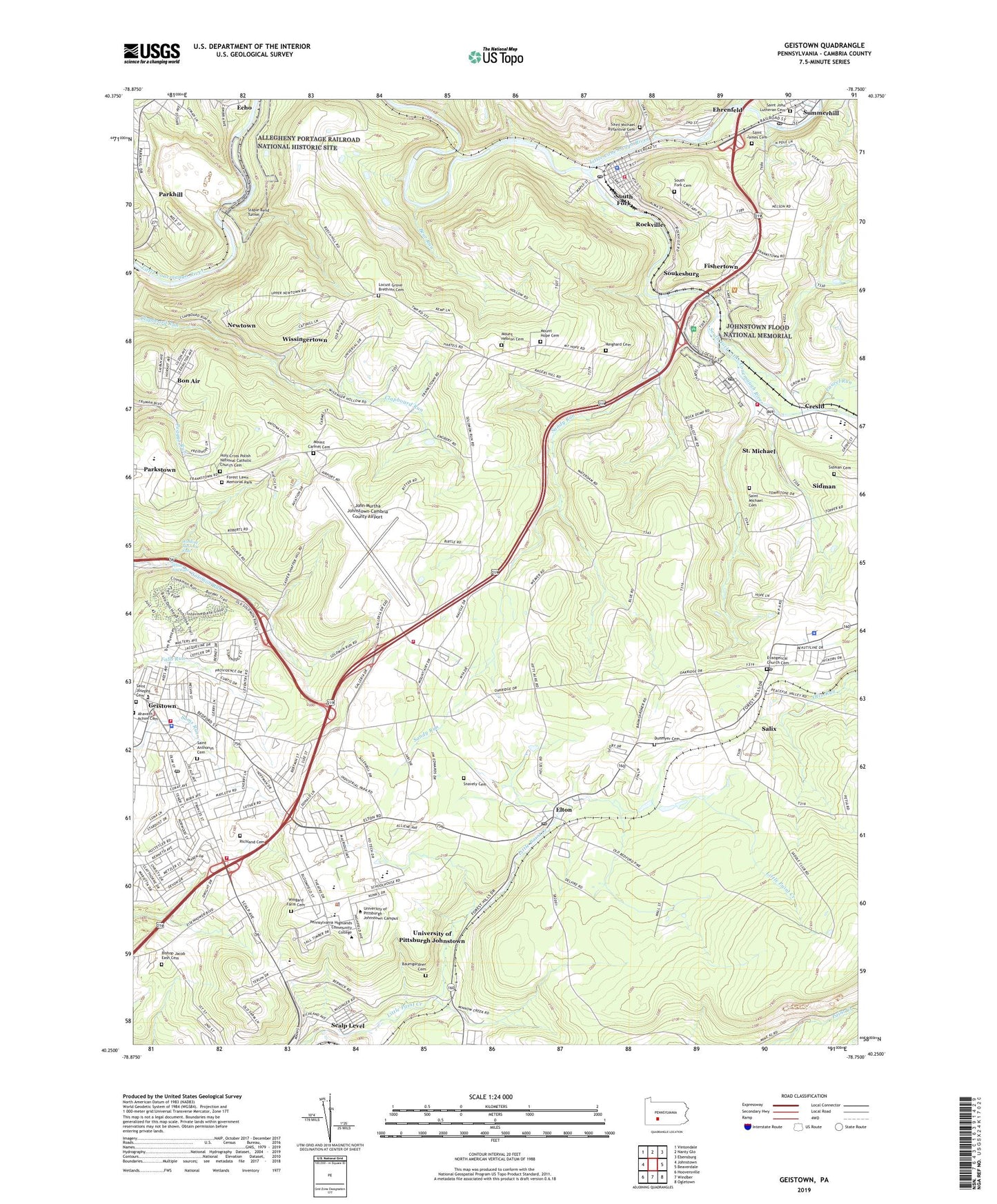
2023 topographic map quadrangle Geistown in the state of Pennsylvania. Scale: 1:24000. Based on the newly updated USGS 7.5' US Topo map series, this map is in the following counties: Cambria. The map contains contour data, water features, and other items you are used to seeing on USGS maps, but also has updated roads and other features. This is the next generation of topographic maps. Printed on high-quality waterproof paper with UV fade-resistant inks.
Quads adjacent to this one:
West: Johnstown
Northwest: Vintondale
North: Nanty Glo
Northeast: Ebensburg
East: Beaverdale
Southeast: Ogletown
South: Windber
Southwest: Hooversville
This map covers the same area as the classic USGS quad with code o40078c7.
Contains the following named places: Adams Police Department, Adams Township Volunteer Fire Company Saint Michael Station 84, Adams-Summerhill High School, Arabian Farm Airport, Arbutus Church, Baumgardner Cemetery, Bear Run, Bel Air Post Office, Bel-Air Shopping Plaza, Bethany Church, Bethel Church, Bishop Jacob Eash Cemetery, Bon Air, Borough of Ehrenfeld, Borough of Geistown, Borough of South Fork, Conemaugh Lake, Conemaugh Valley Elementary School, Creslo, Dunmyer Cemetery, East Hills Ambulance Station 9, Ehrenfeld, Elton, Elton Post Office, Emmanuel Church, Evangelical Church Cemetery, Falls Run, Fishertown, Forest Hills Area Ambulance Association Station 78, Forest Lawn Memorial Park, Geistown, Geistown Borough Police Department, Grace Church, Holy Cross Polish National Catholic Church Cemetery, John Murtha Johnstown-Cambria County Airport, Johnstown Flood National Memorial, Lake Union Church, Laurel Run, Liberty Park, Locust Grove Brethren Cemetery, Locust Grove Church, Maple Grove Church, Mount Calvary Church, Mount Carmel Cemetery, Mount Carmel Church, Mount Hebron Cemetery, Mount Hope Cemetery, Mount Hope Church, Newtown, Number Thirty-Seven, Palestine Church, Parkhill, Pleasant Grove Church, Rachel Hill School, Reighard Cemetery, Richland Cemetery, Richland Greens Golf Course, Richland High School, Richland Junior High School, Richland Mall, Richland Township Fire Department Geistown Station 3, Richland Township Fire Department Solomon Run Station 3, Richland Township Fire Department Station 3 Headquarters, Rockville, Saint Anthonys Cemetery, Saint James Cemetery, Saint John Lutheran Cemetery, Saint Josephs Cemetery, Saint Michael, Saint Michael Byzantine Cemetery, Saint Michael Cemetery, Saint Michael Census Designated Place, Saint Michael Post Office, Saint Michaels Church, Saint Michael-Sidman Census Designated Place, Salix, Salix Census Designated Place, Salix Post Office, Sandy Run, Sidman Cemetery, Sidman Census Designated Place, Sidman Post Office, Snavely Cemetery, Soukesburg, South Fork, South Fork Cemetery, South Fork Little Conemaugh River, South Fork Post Office, South Fork Reservoir Dam Site, South Fork Volunteer Fire Company Station 85, Staple Bend Tunnel, Summerhill Post Office, Township of Conemaugh, Township of Croyle, Township of East Taylor, Township of Richland, University of Pittsburgh - Johnstown Campus, University of Pittsburgh Johnstown Census Designated Place, University Park School, University Park Shopping Center, White Tail Falls, Windber Country Club, Winding Staircase Falls, Wingard Farm Cemetery, Wissingertown, ZIP Codes: 15904, 15934, 15945, 15951, 15952, 15956