MyTopo
Johnstown Pennsylvania US Topo Map
Couldn't load pickup availability
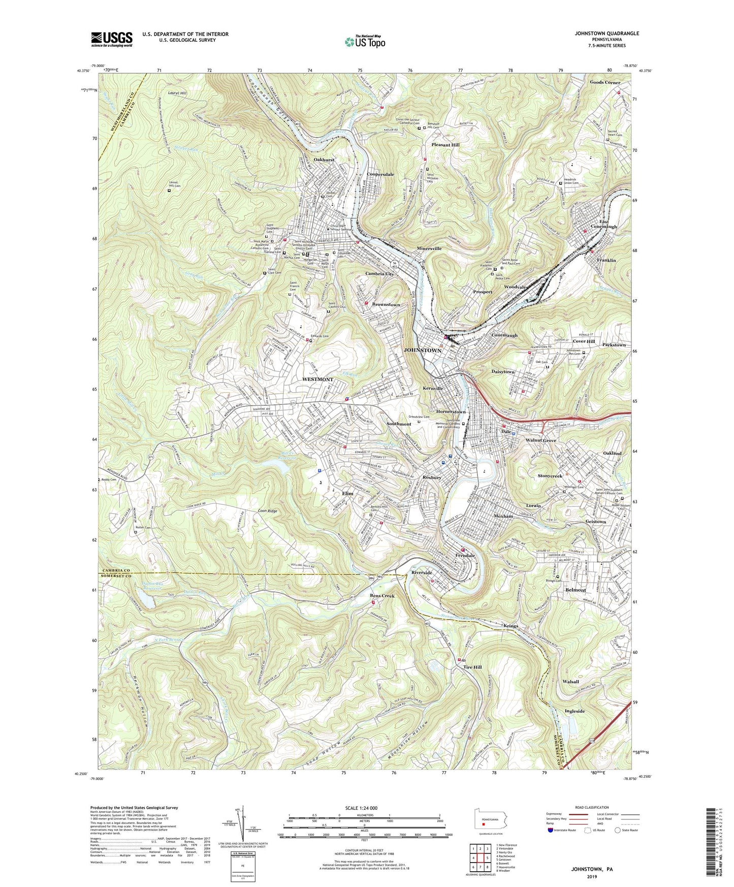
2023 topographic map quadrangle Johnstown in the state of Pennsylvania. Scale: 1:24000. Based on the newly updated USGS 7.5' US Topo map series, this map is in the following counties: Cambria, Somerset, Westmoreland. The map contains contour data, water features, and other items you are used to seeing on USGS maps, but also has updated roads and other features. This is the next generation of topographic maps. Printed on high-quality waterproof paper with UV fade-resistant inks.
Quads adjacent to this one:
West: Rachelwood
Northwest: New Florence
North: Vintondale
Northeast: Nanty Glo
East: Geistown
Southeast: Windber
South: Hooversville
Southwest: Boswell
This map covers the same area as the classic USGS quad with code o40078c8.
Contains the following named places: Ahavath Achim Cemetery, Belmont, Belmont Census Designated Place, Belmont Church, Bens Creek, Benshoff Hill Cemetery, Berkley Hills Cemetery, Berkley Hills Church, Blough Cemetery, Borough of Brownstown, Borough of Daisytown, Borough of Dale, Borough of East Conemaugh, Borough of Ferndale, Borough of Franklin, Borough of Lorain, Borough of Southmont, Borough of Westmont, Brownstown, Calvary Church, Cambria City, Cambria County War Memorial Arena, Central High School, Cheney Run, Cherry Run, Christ Church, Christ the Saviour Cathedral Cemetery, City of Johnstown, Clapboard Run, Cochran Junior High School, Conemaugh, Conemaugh Disaster Assistance Response Team, Conemaugh Memorial Hospital, Conemaugh Memorial Medical Center - Lee Campus, Conemaugh Township Emergency Medical Services Station 640, Conemaugh Township Police Department, Conemaugh Township Volunteer Fire Department Station 610, Conemaugh Valley Junior Senior High School, Conemaugh Volunteer Fire Department and Emergency Medical Service Station 15, Coon Ridge, Coopersdale, Cover Hill, Cover Hill Volunteer Fire Company Station 13, Crichton Rehabilitation Center, Daisytown, Daisytown Volunteer Fire Department Station 18, Dale, Dale Borough Fire Company Station 4, Dale Borough Police Department, Dalton Run, Dalton Run Dam, Dalton Run Reservoir, Decker Cemetery, East Conemaugh, East Conemaugh Post Office, East Taylor Township Volunteer Fire Department Station 17, Eastmont, Edgewood School, Edwards Cemetery, Elim, Elim Census Designated Place, Elk Run, Faith Chapel, Ferndale, Ferndale Police Department, Franklin, Franklin Volunteer Fire Company Station 5, Garfield Junior High School, Goods Corner, Goucher Street School, Grandview Cemetery, Gray Run, Headrick Union Cemetery, Heckman Hollow, Hilltop Ambulance Association Station 21, Hinckston Run, Hinckston Run Dam, Hornerstown, Hungarian Cemetery, Ideal Volunteer Fire Company, Ingleside, Johnstown, Johnstown College, Johnstown Fire Department East End Station 36 - 3, Johnstown Fire Department Station 36 - 1, Johnstown Fire Department West End Station 36 - 2, Johnstown Municipal Golf Course, Johnstown Pet Cemetery, Johnstown Police Department, Johnstown Post Office, Kernville, Kring, Krings, Laurel Hill Cemetery, Laurel Run, Lincoln School, Little Conemaugh River, Little Mill Creek, Lorain, Lorain Borough Volunteer Fire Company, Lower Yoder Fire Tower, Lower Yoder Township Volunteer Fire Department Station 23, Maple Park School, McCort High School, Memorial Auditorium, Middle Taylor Volunteer Fire Department Station 25, Mill Creek, Mill Creek Number Two Dam, Mill Creek Reservoir, Minersville, Mishler, Moonshine Hollow, Moxham, North Fork Bens Creek, North Fork Country Club, Oak Cemetery, Oakhurst, Oakland, Oakland Census Designated Place, Oakland Volunteer Fire Company Station 6, Parkstown, Peggys Run, Pleasant Hill, Pleasant Hill Church, Point Stadium, Potter Cemetery, Prospect, Richland Township Fire Department Belmont, Riverside, Riverside Census Designated Place, Riverside Volunteer Fire Department Station 20, Roddy Cemetery, Rodef Sholom Cemetery, Rosedale, Roxbury, Roxbury Park, Sacred Heart Cemetery, Sacred Heart School, Saint Benedicts School, Saint Casmirs Cemetery, Saint Clair Cemetery, Saint Clair Run, Saint Clements School, Saint Columbas Cemetery, Saint Francis Cemetery, Saint John Gualbert Roman Catholic Cemetery, Saint Marys Byzantine Catholic Cemetery, Saint Marys Cemetery, Saint Michaels School, Saint Nicholas Cemetery, Saint Nicholas School, Saint Nicholas Serbian Orthodox Church Cemetery, Saint Patricks School, Saint Petka Cemetery, Saint Rochus Cemetery, Saint Stephens Cemetery, Saint Theresa Cemetery, Saint Theresa Church, Saint Vladamir Cemetery, Saints Peter and Paul Cemetery, Sams Run, Sandyvale Memorial Gardens and Conservancy, Seventh Ward Civic Association Ambulance Service Station 37, Soap Hollow, Solomon Run, South Fork Bens Creek, Southmont, Southmont Borough Volunteer Fire Company Station 26, Stahl Church, State Rehabilitation Center, Stonycreek, Stonycreek River, Strayer Run, Stutzman School, Sunnehanna Country Club, Tire Hill, Tire Hill Post Office, Township of Lower Yoder, Township of Middle Taylor, Township of Stonycreek, Township of Upper Yoder, Upper Yoder Township Police Department, Upper Yoder Volunteer Fire Company and Emergency Medical Service Station 27, Walnut Grove, Walsall, Washington School, WCRO-AM (Johnstown), West End Ambulance Service Station 35, West Hills Regional Fire Department Station 28 - 1, West Hills Regional Fire Department Station 28 - 2, West Hills Regional Fire Department Station 28 - 3, West Hills Regional Police Department, West Taylor Volunteer Fire Department Station 29, Westmont, Westmont Hilltop High School, Westmont Junior High School, Westmont Shopping Center, Westwood, Westwood Census Designated Place, Westwood School, Westwood Volunteer Fire Company Station 30, WGLU-FM (Johnstown), Wildcat Run, Wissinger Cemetery, WJAC-FM (Johnstown), WJAC-TV (Johnstown), WJNL-AM (Johnstown), WJNL-FM (Johnstown), WJNL-TV (Johnstown), Woodvale, ZIP Codes: 15901, 15902, 15905