MyTopo
Hershey Pennsylvania US Topo Map
Couldn't load pickup availability
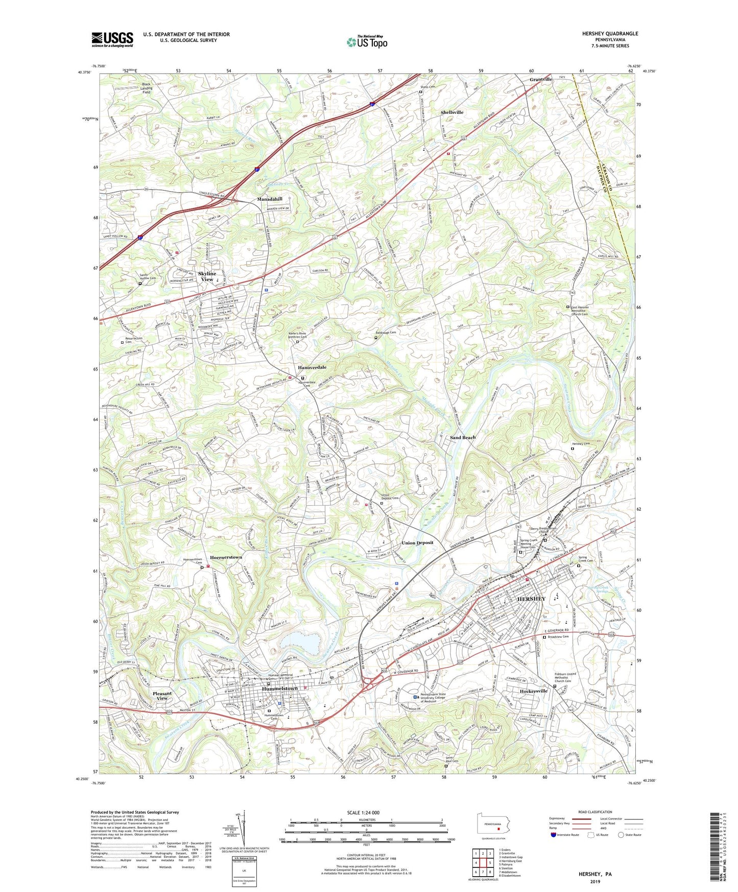
2019 topographic map quadrangle Hershey in the state of Pennsylvania. Scale: 1:24000. Based on the newly updated USGS 7.5' US Topo map series, this map is in the following counties: Dauphin, Lebanon. The map contains contour data, water features, and other items you are used to seeing on USGS maps, but also has updated roads and other features. This is the next generation of topographic maps. Printed on high-quality waterproof paper with UV fade-resistant inks.
Quads adjacent to this one:
West: Harrisburg East
Northwest: Enders
North: Grantville
Northeast: Indiantown Gap
East: Palmyra
Southeast: Elizabethtown
South: Middletown
Southwest: Steelton
Contains the following named places: Alpine Heights, Annie B Nye Elementary School, Auer Field, Balsbaugh Cemetery, Balsbaugh Church, Beaver Creek, Black Landing Field, Borough of Hummelstown, Bow Creek, Branbury Cross, Broadview Cemetery, Brookside Farms Airport, Calvary Church, Crestview Manor, Derry Elementary School, Derry High School, Derry One-Room School, Derry Presbyterian Church Cemetery, Devonshire Crest, East Hanover Church, East Hanover Elementary School, East Hanover Mennonite Church Cemetery, Elizabeth Z Price Elementary School, Englewood, Fishburn United Methodist Church Cemetery, Fishburns Church, Founders Hall, Glenn Acres, Grantville Volunteer Fire Company Station 39, Greenbriar, Hanover Hills, Hanoverdale, Hanoverdale Cemetery, Hershey, Hershey Air Park, Hershey Cemetery, Hershey Census Designated Place, Hershey Country Club and Golf Courses, Hershey Gardens, Hershey Highmeadow Camp, Hershey Information Center, Hershey Intermediate School, Hershey Museum of American Life, Hershey Nursery, Hershey Park, Hershey Park Arena, Hershey Parkview Golf, Hershey Post Office, Hershey Spring Creek Golf, Hershey Volunteer Fire Company Station 48, High Ridge, Hillymeade, Historical Church, Hockersville, Hoernerstown, Hoernerstown Cemetery, Hotel Hershey Golf Course, Hummel Memorial Cemetery, Hummelstown, Hummelstown Cemetery, Hummelstown Chemical Fire Company Station 46, Hummelstown Dam, Hummelstown Police Department, Hummelstown Post Office, Hummelstown Quarry, Kellock Run, Kiefer's River Brethren Cemetery, Long Lane Acres, Lower Dauphin High School, M S Hershey Medical Center Helistop, Manada Creek, Manadahill, Manor Acres, Milton Hershey High School, North Skyline View, Nyes Run, Oakmont, Park Village Plaza, Penn State Milton S Hershey Medical Center, Pennsylvania State Police Troop H Headquarters and Harrisburg Station, Pine Acres, Pleasant View, Resurrection Cemetery, Saint Joan of Arc School, Saint Johns Church, Saint Paul Cemetery, Sand Beach, Sand Beach Mission, Sandy Hollow Cemetery, Shells Cemetery, Shells Church, Shellsville, Shoops Church, Skyline View, Skyline View Census Designated Place, South Central Emergency Medical Ambulance Services Station 7, South Hanover Elementary School, Spring Creek, Spring Creek Cemetery, Spring Creek Church, Spring Creek Manor, Spring Creek Meeting House Cemetery, Spring Creek Springs, Stafford Heights, Swatara, The Hershey Lodge and Convention Center, The Hotel Hershey, Township of Derry, Township of South Hanover, Township of West Hanover, Union Deposit, Union Deposit Cemetery, Union Deposit Census Designated Place, Union Deposit Volunteer Fire Company Station 47, Union Deposit Volunteer Fire Company Station 47 - 2, Valley View Acres, Walnut Run, West Hanover School, West Hanover Township Fire Company 1 Station 36 - 1, West Hanover Township Fire Company 1 Station 36 - 2, Zoo America, ZIP Codes: 17033, 17036