MyTopo
Indiantown Gap Pennsylvania US Topo Map
Couldn't load pickup availability
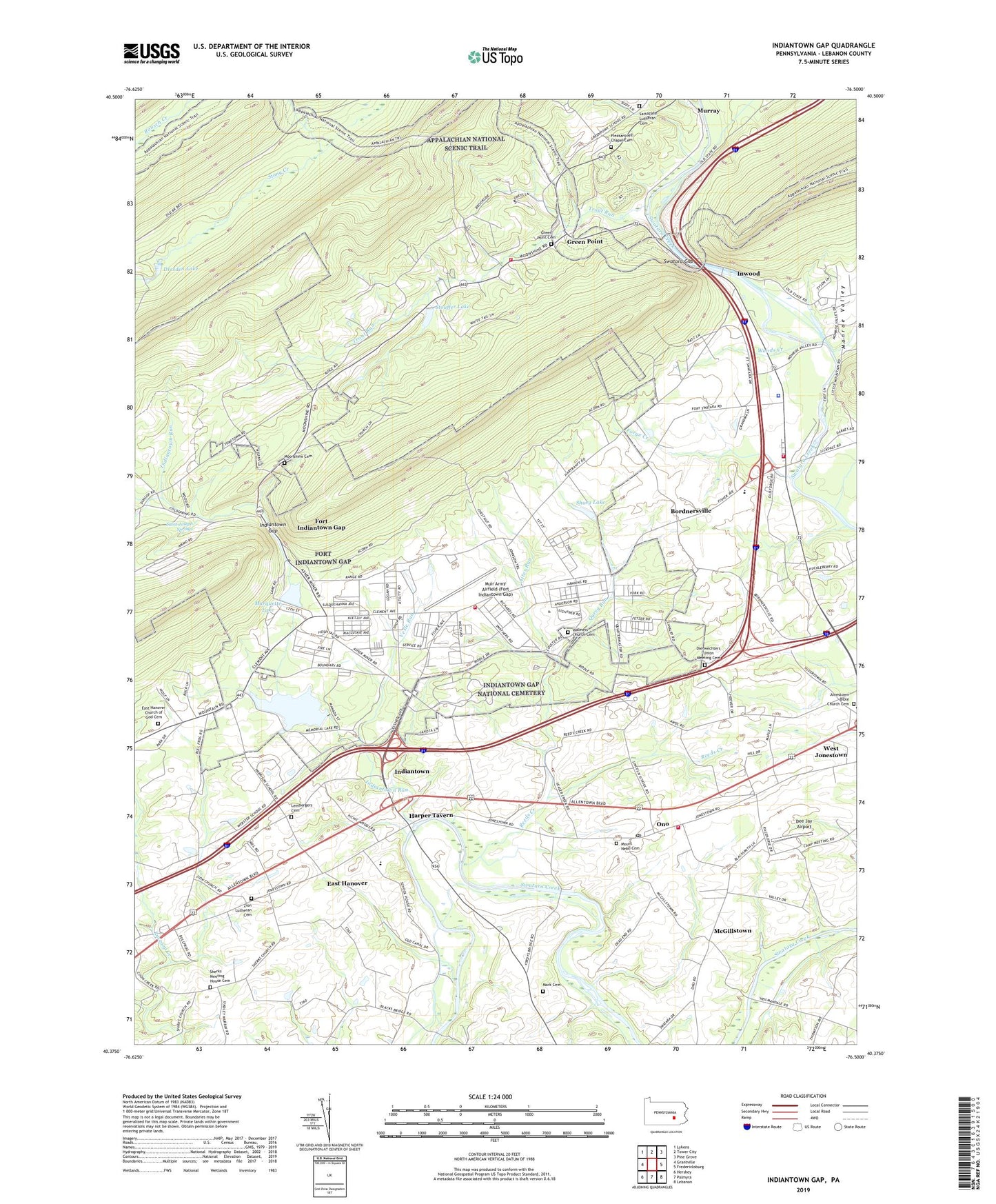
2023 topographic map quadrangle Indiantown Gap in the state of Pennsylvania. Scale: 1:24000. Based on the newly updated USGS 7.5' US Topo map series, this map is in the following counties: Lebanon. The map contains contour data, water features, and other items you are used to seeing on USGS maps, but also has updated roads and other features. This is the next generation of topographic maps. Printed on high-quality waterproof paper with UV fade-resistant inks.
Quads adjacent to this one:
West: Grantville
Northwest: Lykens
North: Tower City
Northeast: Pine Grove
East: Fredericksburg
Southeast: Lebanon
South: Palmyra
Southwest: Hershey
This map covers the same area as the classic USGS quad with code o40076d5.
Contains the following named places: Aires Run, Bashore Boy Scout Camp, Blue Rock Farm, Bordnersville, Dee Jay Airport, Dierwechters Union Meeting Cemetery, Dresden Lake, East Hanover, East Hanover Church of God, East Hanover Church of God Cemetery, East Hanover Elementary School, Emmanuel United Methodist Church, Emrich Farm, Forge Creek, Fort Indiantown Gap, Fort Indiantown Gap Census Designated Place, Fort Indiantown Gap Training Site, Franklin School, Green Point, Green Point Cemetery, Green Point Station, Harper Tavern, Hershey School, Indiantown, Indiantown Gap, Indiantown Gap Fire Department, Indiantown Gap National Cemetery, Indiantown Gap Station, Indiantown Run, Inwood, Jonestown Bible Church Cemetery, Lembergers Cemetery, Lickdale, Lickdale School, Mark Cemetery, Marquette Lake, McGill School, McGillstown, Memorial Lake Dam, Memorial Lake State Park, Metropolitan Edison Substation, Minnich Farm, Monroe Creek, Monroe Valley, Moonshine Cemetery, Moonshine Church, Mount Nebo Cemetery, Mount Zion School of Ministry, Muir Army Airfield (Fort Indiantown Gap), Murray, Northern Lebanon Fire and Emergency Services Station 57, Ono, Ono Post Office, Ono United Methodist Church, Pennsylvania State Police Department Troop L Jonestown Station, Pleasant Hill Chapel Cemetery, Plenty Good Dairy, Qureg Run, Rausch Creek, Rausch Gap, Reeds Creek, Reservation Dam, Saint Joseph Springs, Sattazahn Church, Sattazahn Lutheran Cemetery, Sherks Church, Sherks Meeting House Cemetery, Sherman School, Shuey Lake, Shuey Lake Dam, State Game Lands Number 80, Stouffer Lake, Stouffer Lake Dam, Swatara Gap, Swatara State Park, Township of East Hanover, Township of Union, Trinity United Methodist Church, Trout Run, Union Chapel, Union Township Hall, Verizon Substation, Verizon Wireless Communications Tower, Vesle Run, Walmers Church, Walmers Church Cemetery, Washington School, Woods Creek, Zion Lutheran Cemetery, Zion Luthern Church, ZIP Codes: 17038, 17077