MyTopo
Palmyra Pennsylvania US Topo Map
Couldn't load pickup availability
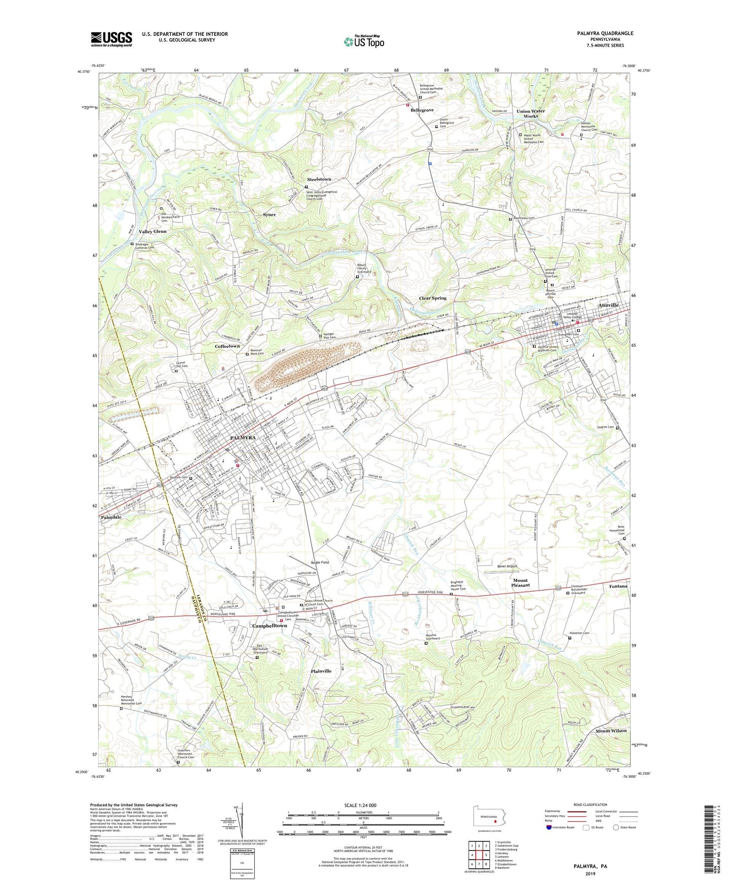
2019 topographic map quadrangle Palmyra in the state of Pennsylvania. Scale: 1:24000. Based on the newly updated USGS 7.5' US Topo map series, this map is in the following counties: Lebanon, Dauphin. The map contains contour data, water features, and other items you are used to seeing on USGS maps, but also has updated roads and other features. This is the next generation of topographic maps. Printed on high-quality waterproof paper with UV fade-resistant inks.
Quads adjacent to this one:
West: Hershey
Northwest: Grantville
North: Indiantown Gap
Northeast: Fredericksburg
East: Lebanon
Southeast: Manheim
South: Elizabethtown
Southwest: Middletown
Contains the following named places: Annville, Annville Census Designated Place, Annville Cleona Fire District Station 58, Annville Elementary School, Annville Police Department, Annville Post Office, Annville United Brethren Cemetery, Annville United Zion Cemetery, Annville-Cleona High School, Bachman Run, Bellegrove, Bellegrove United Methodist Church Cemetery, Bellegrove Volunteer Fire Company Station 6, Bindnagle Lutheran Cemetery, Blauch Family Graveyard, Borough of Palmyra, Bowman - Mark Cemetery, Brandt View Farms, Brightbill Meeting House Cemetery, Brindnagles Church, Buckholder Run, Calvary Church, Campbell, Campbelltown, Campbelltown Census Designated Place, Campbelltown Post Office, Campbelltown United Christian Cemetery, Campbelltown Volunteer Fire Company Station 2, Christian Burckholder Graveyard, Citizens Fire Company 1 Station 1, Clear Spring, Coffeetown, Dohner Mennonite Church Cemetery, Dohners Church, Eby - Oberholtzer Graveyard, Evergreen Cemetery, Forge Street School, Garfield School, Gingrich Run, Gravel Hill, Gravel Hill Cemetery, Gravel Hill Church, Hemperly School, Hershey Church, Hershey Reformed Mennonite Cemetery, Hostetter Cemetery, Kauffmans Cemetery, Kauffmans Church, Killinger Creek, Kruger Airport, Lebanon Valley College, Marbet Farms, Millard Airport, Mount Annville Cemetery, Mount Pleasant, Mount Wilson, Mumma Graveyard, Nafzger Plot Cemetery, North Annville Elementary School, North Londonderry Township Police Department, Northside Elementary School, Old Hershey Farm Cemetery, Palmdale, Palmdale Census Designated Place, Palmyra, Palmyra Cemetery, Palmyra Middle School, Palmyra Post Office, Palmyra Senior High School, Palmyra Shopping Center, Palymra Police Department, Pine Street Elementary School, Plainville, Quittapahilla Creek, Raccoon Creek, Reigle Field, Reist Homestead Cemetery, Rover Airport, Saint Johns Evangelical Congregational Church Cemetery, Salem United Church of Christ Cemetery, Siegrist Cemetery, Smith Heliport, South Bellegrove Cemetery, South Londonderry Township Police Department, Stauffers Mennonite Church Cemetery, Steelstown, Syner, Township of Annville, Township of North Annville, Township of North Londonderry, Township of South Annville, Union Water Works, Union Water Works Fire Company Station 7, Valley Glenn, Water Works Dam, Water Works United Methodist Cemetery, WCTX-FM (Palmyra), West High School, ZIP Codes: 17003, 17010, 17078