MyTopo
Unionville Pennsylvania US Topo Map
Couldn't load pickup availability
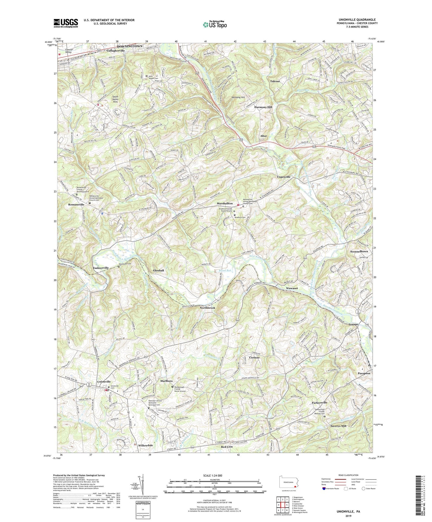
2019 topographic map quadrangle Unionville in the state of Pennsylvania. Scale: 1:24000. Based on the newly updated USGS 7.5' US Topo map series, this map is in the following counties: Chester. The map contains contour data, water features, and other items you are used to seeing on USGS maps, but also has updated roads and other features. This is the next generation of topographic maps. Printed on high-quality waterproof paper with UV fade-resistant inks.
Quads adjacent to this one:
West: Coatesville
Northwest: Wagontown
North: Downingtown
Northeast: Malvern
East: West Chester
Southeast: Wilmington North
South: Kennett Square
Southwest: West Grove
Contains the following named places: Almshouse Cemetery, Altor, Barnard Run, Blackhorse Run, Bob Shannon Memorial Field, Bradford Cemetery, Bradford Friends Burial Ground, Bradford Heights Elementary School, Brayman Dam, Broad Run, Charles F Patton Middle School, Chester County, Chester County Prison, Copeland School, Copesville, Corinne, Corundum Run, East Bradford Township Building, East Bradford Township Police Station, East Branch Brandywine Creek, East Marlborough Township Building, East Marlborough Township Police Department, Ebenezer African Methodist Episcopal Cemetery, Embreeville, Embreeville Dam, Embreeville Fire Station, Embreeville State Hospital, Feldspar Run, Gallagherville, Glenhall, Harmony Hill, Indian Hannah Run, John Smedley Run, Lenape, Lost Trail Creek, Marlboro, Marlborough Friends Burial Ground, Marshallton, Marshallton Barrens, Marshallton Census Designated Place, Marshallton United Methodist Church Cemetery, Mason Dixon Run, Northbrook, Owl Run, Parkersville, Parkersville Friends Meeting Cemetery, Pennsylvania State Police Barracks, Pennsylvania State Police Station, Pennsylvania State Police Troop J Embreeville Station, Pennsylvania State Troop J Embreeville Police Station, Philadelphia YMCA Camp, Plum Run, Po - Mar - Lin Fire Company Station 36, Pocopson, Pocopson Home, Pocopson Post Office, Pocopson Township Building, Red Lion, Red Tail Run, Romansville, Romansville Friends Burying Ground, Romansville United Methodist Church Cemetery, Saint Joseph Cemetery, Saverys Mill, Sconnelltown, Serpentine Run, Talcose, Taylor Run, Thorndale, Thorndale Volunteer Fire Company Station 38, Township of East Bradford, Township of East Marlborough, Township of Newlin, Township of Pocopson, Township of West Bradford, Unionville, Unionville Barrens, Unionville Cemetery, Unionville Census Designated Place, Unionville Elementary School, Unionville High School, Unionville Post Office, Valley Creek, Wawaset, WCHE-AM (West Chester), West Bradford Elementary School, West Bradford Fire Company - Poorhouse Road Station 39, West Bradford Fire Company Station 39, West Bradford Township Building, West Branch Brandywine Creek, Wickersham Run, Woodwards Corner, ZIP Code: 19375