MyTopo
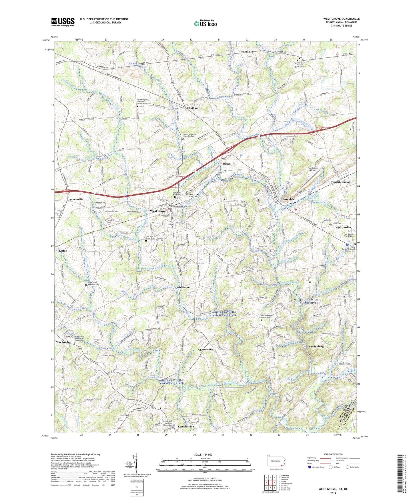
West Grove Pennsylvania US Topo Map
Couldn't load pickup availability
2023 topographic map quadrangle West Grove in the states of Pennsylvania, Delaware. Scale: 1:24000. Based on the newly updated USGS 7.5' US Topo map series, this map is in the following counties: Chester, New Castle. The map contains contour data, water features, and other items you are used to seeing on USGS maps, but also has updated roads and other features. This is the next generation of topographic maps. Printed on high-quality waterproof paper with UV fade-resistant inks.
Quads adjacent to this one:
West: Oxford
Northwest: Parkesburg
North: Coatesville
Northeast: Unionville
East: Kennett Square
Southeast: Newark East
South: Newark West
Southwest: Bay View
This map covers the same area as the classic USGS quad with code o39075g7.
Contains the following named places: African Union Church of Londongrove Cemetery, Auburn Regular Baptist Cemetery, Auburn School, Avon Grove High School, Avondale, Avondale Fire Company Station 23, Avondale Post Office, Baker, Borough of Avondale, Borough of West Grove, Brickyard Run, Broad Run, Chandlers Run, Chatham, Chesterville, Christ Community Fellowship Cemetery, D'Amico Quarry, Egypt Run, Evans Brook, Franklin School, Ginns Airport, Great Good Place, Green Valley Farms Dam, Green Valley Farms Lake, Harmony Road Cemetery, Indian Run, Jennersville, Kelton Airport, Kemblesville Methodist Church Cemetery, Lamborn Run, Landenberg, Landenberg Post Office, Laurel Woods Run, Lenni Lenape Run, Loch Nairn Golf Club, London Grove, London Grove Friends Burial Ground, Maccabees Home, Maple Grove School, Middle Branch White Clay Creek, Miller Run, Mushroom Run, New Bolton Center The University of Pennsylvania School of Veterinary Medicine, New Garden, New Garden Airport, New Garden Friends Cemetery, New Garden Orthodox Friends Cemetery, New Garden Station, New London Academy, New London Presbyterian Church Cemetery, New West Grove Cemetery, North Bank School, Pennsylvania State Police Troop J Avondale Station, Saint Francis Xavier Church, Saint John's Episcopal Cemetery, Saint Marys Cemetery, Southeastern Chester County Refuse Authority, Southern Chester County Regional Police Department, Toughkenamon, Toughkenamon Census Designated Place, Toughkenamon Post Office, Township of Franklin, Township of London Grove, Township of New Garden, Township of Penn, Trout Run, Upland Country Day School, Walnut Run, Water Plug Prong, West Branch White Clay Creek, West Grove, West Grove Borough Police Department, West Grove Fire Company Station 22 Main, West Grove Post Office, Whiskey Run, White Clay Wild and Scenic River, Wickerton, Woodville, ZIP Codes: 19311, 19350, 19374, 19390