MyTopo
Downingtown Pennsylvania US Topo Map
Couldn't load pickup availability
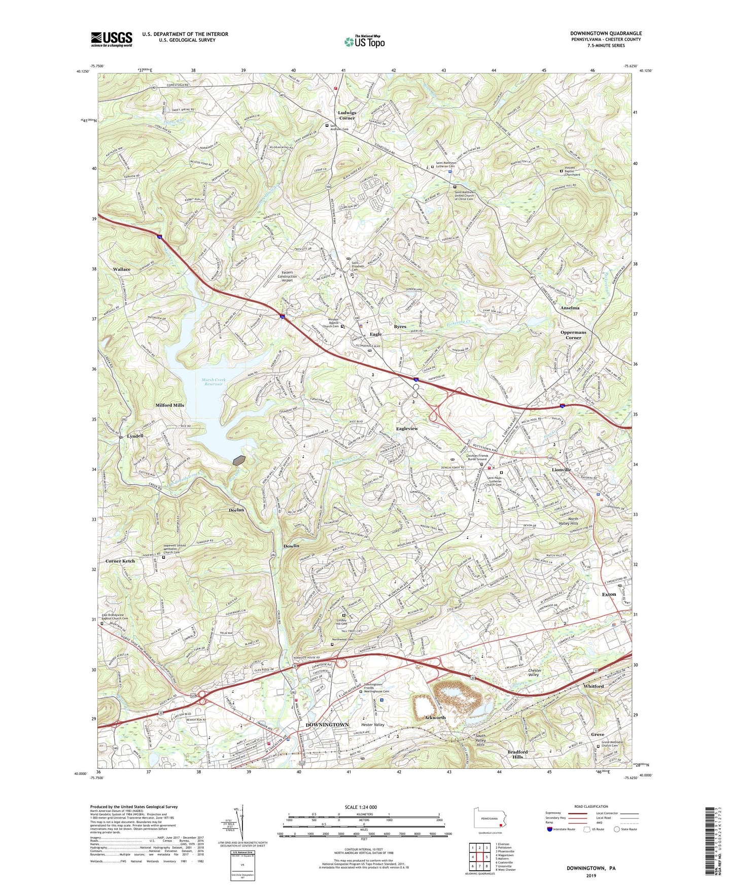
2023 topographic map quadrangle Downingtown in the state of Pennsylvania. Scale: 1:24000. Based on the newly updated USGS 7.5' US Topo map series, this map is in the following counties: Chester. The map contains contour data, water features, and other items you are used to seeing on USGS maps, but also has updated roads and other features. This is the next generation of topographic maps. Printed on high-quality waterproof paper with UV fade-resistant inks.
Quads adjacent to this one:
West: Wagontown
Northwest: Elverson
North: Pottstown
Northeast: Phoenixville
East: Malvern
Southeast: West Chester
South: Unionville
Southwest: Coatesville
This map covers the same area as the classic USGS quad with code o40075a6.
Contains the following named places: Academy Dam, Ackworth, Anselma, Ashbridge Square Shopping Center, Beaver Creek, Beaver Creek Dam, Beaver Creek Elementary School, Belvidere, Black Horse Creek, Borough of Downingtown, Bradford Hills, Brandywine Square Shopping Center, Byers, Chester County Development Council, Chester County Education Service Center, Clemens Shopping Center, Corner Ketch, Culbertson Run, Devereux School, Dorlan, Dowlin, Downingtown, Downingtown Boro Hall, Downingtown East High School, Downingtown Fire Department - Alert Fire Company Station 45, Downingtown Fire Department - Minquas Fire Company 2 Emergency Medical Services, Downingtown Friends Meetinghouse Cemetery, Downingtown Industrial and Agricultural School, Downingtown Inn Golf Course, Downingtown Library, Downingtown Middle School, Downingtown Ninth Grade Center, Downingtown Police Department, Downingtown Police Station, Downingtown Post Office, Downingtown Quarry, Downingtown West High School, Eagle, Eagle Census Designated Place, Eagleview Census Designated Place, East Brandywine Baptist Church Cemetery, East Brandywine Church, East Caln Township Building, East Nantmeal, East Nantmeal Township Building, East Ward Elementary School, Exton Airport, Exton Census Designated Place, Exton Post Office, F Houston Mcilvain Dam, Fetters Construction Airport, Font, Friends School, Grove, Grove Methodist Church Cemetery, Hester Valley, Hopewell School, Hopewell United Methodist Church Cemetery, Lindley Hill Cemetery, Lionville, Lionville Census Designated Place, Lionville Elementary School, Lionville Fire Company Station 47, Lionville Middle School, Lionville Post Office, Lionville Station, Ludwigs Corner, Ludwigs Corner Fire Company Station 73, Lyndell, Lyndell Post Office, Marchwood Shopping Center, Marsh Creek, Marsh Creek Reservoir, Marsh Creek State Park, Marsh Creek State Park Boat Ramp, Mary C Howse Elementary School, Matthews, Milford Mills, North Park Plaza, North Valley Hills, Northwood Cemetery, Oakland, Oppermans Corner, Pickering Creek Industrial Park, Pickering Valley Elementary School, Prospect School, Reeds Road, Route 100 Shoppes, Saint Andrews Cemetery, Saint Andrews Church, Saint Elizabeth Cemetery, Saint John Vianney Medical Center, Saint Matthews Lutheran Cemetery, Saint Matthews Lutheran Church, Saint Matthews United Church of Christ, Saint Matthew's United Church of Christ Cemetery, Saint Pauls Lutheran Church, Saint Pauls Lutheran Church Cemetery, Saint Pauls United Church of Christ, Shamona Creek, Shamona Creek Elementary School, South Valley Hills, Township of East Caln, Township of Upper Uwchlan, Township of Uwchlan, Union School, Upattinas School, Upper Uwchlan Township Building, Upper Uwchlan Township Police Department, Uwchlan Ambulance, Uwchlan Ambulance - Station 87, Uwchlan Friends Burial Ground, Uwchlan Hills Elementary School, Uwchlan Township Building, Uwchlan Township Police Department, Uwchlan Township Police Station, Uwchland Post Office, Vincent Baptist Churchyard, Vincent Church, Wallace, West Vincent Post Office, West Vincent Township Police Department, West Whiteland Post Office, West Whiteland Township Building, West Whiteland Township Police Department, Whitford, Whitford Post Office, Whitford Station, Windsor Baptist Church Cemetery, Windsor Church, Woodbine, ZIP Codes: 19335, 19341, 19425