MyTopo
West Chester Pennsylvania US Topo Map
Couldn't load pickup availability
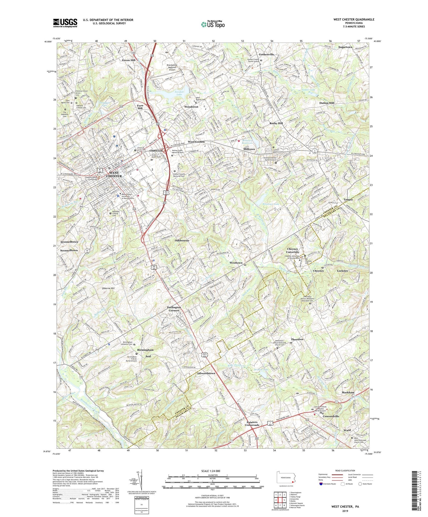
2023 topographic map quadrangle West Chester in the state of Pennsylvania. Scale: 1:24000. Based on the newly updated USGS 7.5' US Topo map series, this map is in the following counties: Chester, Delaware. The map contains contour data, water features, and other items you are used to seeing on USGS maps, but also has updated roads and other features. This is the next generation of topographic maps. Printed on high-quality waterproof paper with UV fade-resistant inks.
Quads adjacent to this one:
West: Unionville
Northwest: Downingtown
North: Malvern
Northeast: Valley Forge
East: Media
Southeast: Marcus Hook
South: Wilmington North
Southwest: Kennett Square
This map covers the same area as the classic USGS quad with code o39075h5.
Contains the following named places: Allegiance, Applebrook Golf Course, Ashbridge Farms, Ashbridge Run, Ashwell, Battlefield of the Brandywine, Bennetts Run, Benoni Run, Bethlehem United Methodist Church Cemetery, Bible Baptist Cemetery, Birdwood Hill, Birmingham, Birmingham Estates, Birmingham Hunt, Birmingham Lafayette Cemetery, Birmingham Township Building, Borough of West Chester, Bow Tree, Bradford Plaza Shopping Center, Brandywine at Thornbury, Brandywine Battlefield State Park, Brandywine Business Center, Brandywine Hunt, Brandywine Regional Airport, Bridlewood Farm, Brinton Lake, Brinton Lake Corporate Center, Brinton Run, Brinton Woods, Brintons Bridge, Brintons Mill, Brintons Quarry Barrens, Camp Sunshine, Carriages at Cobblestones, Carter Industrial Park, Caswallen, Century Farms, Chatwood, Chester County Chamber of Commerce, Chester County Governmnet Service Center, Chester County Memorial Park, Chestnut Grove Annex Cemetery, Chestnut Grove Cemetery, Cheyney, Cheyney University Census Designated Place, Cheyney University of Pennsylvania Athletic Fields, Cider Knoll, Clock Tower Woods, Cobblestones at Thornbury, Commons at Goshen, Concord Creek, Concord Friends Cemetery, Concord Friends Orthodox Burial Ground, Concord Interplex Business Center, Concord Mills Dam, Concordville, Concordville Industrial Park, Coopersmith Park, Coventry Village, Darlington Corners, Deborahs Run, Deer Pointe, Deer Run Industrial Park, Dilworthtown, Dilworthtown Census Designated Place, Dilworthtown Oak Estates, Dilworthtown Woods, Dutton Mill, Dutts Mill, East Branch Chester Creek, East Goshen Township Building, East Goshen Township Park, Everhart Park, Fair Acres Farm, Fair Meadow, Fern Hill, Fern Hill Barrens, Fieldpoint, Fox Kane Industrial Park, Fox Lair, Gay Street Plaza Shopping Center, George Smedley Run, Gneiss Quarry, Golf Course at Glen Mills, Goshen Commons, Goshen Corporate Park, Goshen Corporate Park West, Goshen Friends Burial Ground, Goshen Terrace, Goshen Village Shopping Center, Goshen West, Goshen Woods Business Park, Goshenville, Grace Villa, Grand Oak Run, Green Hill, Green Lane Village, Green Manor Farm, Green Mount Cemetery, Greenbriar at Thornbury, Hallowell Park, Hamilton Place, Heartsease, Hersheys Mill Barrens, Hickman Family Burial Ground, Hilloch Manor, Hummingbird Farm, Hunt Country, Hyllwynd, Jerrehian Estates, Kirby Woods, Land Grant Farms, Locksley, Locksley Crossing, Lower Dam, Lower Lake, Markham, Marshall Square, Marydell Farms, Memel Farms, Meriweather Farms, Milltown, Milltown Dam, Milltown Reservoir, Newlin Grist Mill Park, Oakbourne, Oakbourne Park, Oakland Friends Cemetery, Old Cheyney Cemetery, Osborne Hill, O'Shields - Stevenson Stadium, Painters Crossing, Painters Crossroads, Pamona Park, Park Valley Corporate Center, Park Woods, Penn Oaks Country Club, Penns Grant, Pennwood South, Pepple, Pin Oak Farms, Pleasant Grove, Plumly, Plumly Acres, Plumly Farms, Pocopson Creek, Private Dam, Radley Run, Radley Run Country Club, Reserve at Chadds Ford, Revolutionary Farm, Ridley Creek Dam, Rockland Village I and II, Rocky Hill, Rolling Green Memorial Park, Rollinwood, Rosedale Friends Cemetery, Roundelay, Rustin Park, Saint Agnes Cemetery, Saint Johns Episcopal Church Cemetery, Saint Vincent De Paul Camp, Seal, Serpentine Acres, Sharpless Lake, Sharpless Lake Dam, Shiloh Woods, Shoppes at Brinton Lake Shopping Center, Shugart Run, Sinkler Dam, Sinkler Lake, Spring Valley Business Park, Squire Cheyney Farm Park, Strasburg Court, Suburban Village, Sugartown, Tanguy, The Commons of Thornbury Shopping Center, The Knolls of Birmingham, The Oaklands Cemetery, The Village Shop Center at Painters Crossroads Shopping Center, Thornbury, Thornbury African Methodist Episcopal Cemetery, Thornbury Hunt, Thornbury Knoll, Thornbury Township Park, Thornton, Tiberton, Township Line Dam, Township of Birmingham, Township of East Goshen, Township of Thornbury, Township of West Goshen, Township of Westtown, Twin Bridge Farm, Twin Creeks at Mendenhall, Waln Run, Ward, West Chester, West Chester Country Club, West Chester Reservoir, West Chester Sports Complex, West Goshen, West Goshen Census Designated Place, West Goshen Community Park, West Goshen Hills, West Goshen Park, West Goshen Shopping Center, West Wynn, Westmount, Westover Farms, Westtown, Westtown Acres, Westtown Country Estates, Westtown Dam, Westtown Hillside, Westtown Knoll, Westtown Lake, Westtown Park, Westtown School Lake Dam, Westtown Village Shopping Center, White Chimneys, Willow Brook Industrial Park, Windmere Place, Windon, Woodcock Farm, Woodcrest, Worington Commons, Wylie Farms, Wyllpen Farms, ZIP Codes: 19319, 19373, 19380, 19382, 19383