MyTopo
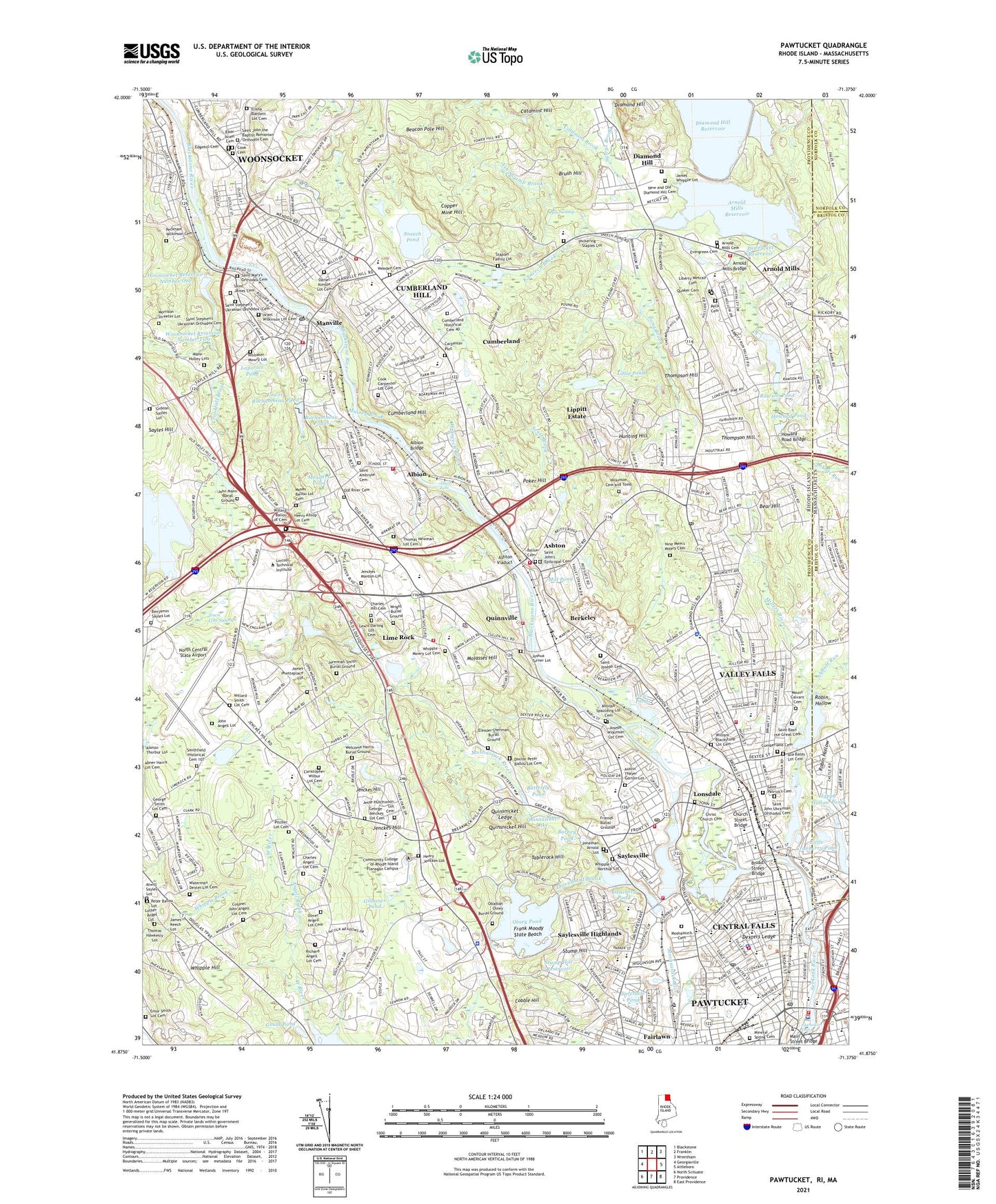
Pawtucket Rhode Island US Topo Map
Couldn't load pickup availability
2024 topographic map quadrangle Pawtucket in the states of Rhode Island, Massachusetts. Scale: 1:24000. Based on the newly updated USGS 7.5' US Topo map series, this map is in the following counties: Providence, Bristol, Norfolk. The map contains contour data, water features, and other items you are used to seeing on USGS maps, but also has updated roads and other features. This is the next generation of topographic maps. Printed on high-quality waterproof paper with UV fade-resistant inks.
Quads adjacent to this one:
West: Georgiaville
Northwest: Blackstone
North: Franklin
Northeast: Wrentham
East: Attleboro
Southeast: East Providence
South: Providence
Southwest: North Scituate
Contains the following named places: Abbott Run, Adams Shopping Plaza Shopping Center, Albion, Albion Dam, Albion Falls, Albion Historic District, Albion Mill, Angell Brook, Ann and Hope Street Shopping Center, Arnold Mills, Arnold Mills Cemetery, Arnold Mills Historic District, Arnold Mills Reservoir, Ash Swamp, Ash Swamp Brook, Ashton, Ashton Dam, Ashton Historic District, Atwill Sayles Lot, Austin Thayer Gorton Lot, Ballou Cemetery, Barney Pond, Barney Pond Dam, Beacon Pole Hill, Bear Hill, Benjamin Sayles Lot, Berkeley, Berkeley Mill Village Historic District, Blackstone Canal, Blackstone River, Blackstone River Reservoir, Bleachery Pond, B'Nai Israel Cemetery, Bridge Mill Power Plant, Brush Hill, Butterfly Pond, Camp Swamp, Carpenter Plot, Catamint Brook, Central Falls, Central Falls Dam, Central Falls Mill Historic District, Central Street School Historic District, Chapel Four Corners, Christ Church Cemetery, Church Hill Industrial District, City of Central Falls, Cobble Hill, Colonel John Angell Lot Cemetery, Conklin Limestone Quarry, Cook Cemetery, Copper Mine Hill, Crookfall Brook, Cumberland, Cumberland Cemetery, Cumberland Hill, Cumberland Hill Census Designated Place, Cumberland Mills, Cumberland Plaza Shopping Center, Dexter Quarry, Dexters Ledge, Diamond Hill, Diamond Hill Reservoir, Diamond Hill Reservoir Dam, Diamond Hill Vineyards, East Sneech Brook, Echo Hill Farm, Eleazer Sherman Burial Ground, Emor Smith Lot Cemetery, Evergreen Cemetery, Fairlawn, Follett-Carpenter House and Farm, Frank Moody State Beach, Franklin Farm, Friends Burial Grounds, George Smith Lot Cemetery, George Washington Memorial Park, Gideon Sayles Lot, Gilbanes Pond, Gould Pond, Happy Hollow, Happy Hollow Pond, Happy Hollow Pond Dam, Henry Jenckes Lot, Howard Pond, Hunting Hill, James Keech Lot, James Phetteplace Lot, James Whipple Lot, Jenckes - Manton Lot, Jenckes Hill, Jenks Park, John Angell Lot, Jonathan Arnold Lot, Joshua Turner Lot, Laportes Pond, Liberty Metcalf Cemetery, Lime Rock, Limerock Village Historic District, Lincoln Center Mall Shopping Center, Lincoln Country Club, Lincoln Greyhound Park, Lincoln Mall Shopping Center, Lincoln Shopping Center, Lincoln Woods, Lincoln Woods State Park, Lippitt Estate, Little Cranberry Pond, Little Orchard Brook, Little Pond, Long Brook, Lonsdale, Lonsdale Historic District, Lonsdale Station, Lower Rochambeau Pond, Luther - Angel Lot, Mann - Holley Lots, Manville, Manville Dam, Manville Mill, Manville Pond, Mapleshade farm, Meaders Pond, Mill Pond, Millers River, Mineral Spring Cemetery, Molasses Hill, Monastery Brook, Monastery Heights, Morrison - Streeter Lot, Moshassuck Cemetery, Mount Calvary Cemetery, Mussey Brook, New and Old Diamond Hill Cemetery, New Pond, Nine Man Misery, North Central State Airport, Obadiah Olney Burial Ground, Old Ashton Historic District, Old River Cemetery, Olney Pond, Olney Pond Dam, Pawtucket, Pawtucket Armory, Pawtucket Falls, Pawtucket Reservoir, Pawtucket Reservoir Dam, Peck Cemetery, Peter Ballou Lot, Phantom Farm, Pickering - Staples Lot, Pleasant View, Poker Hill, Pratt Dam, Quaker Cemetery, Quality Hill Historic District, Quinnville, Quinsnicket Hill, Quinsnicket Lake, Quinsnicket Ledge, Rawson Pond, Rawson Pond Dam, Reservoir Number 1, Reservoir Number 2, Robin Hollow, Robin Hollow Pond, Robin Hollow Pond Dam, Rochambeau Ponds, Saint Ambrose Cemetery, Saint Basil the Great Cemetery, Saint James Cemetery, Saint John the Baptist Romanian Orthodox Cemetery, Saint John Ukrainian Orthodox Cemetery, Saint John's Episcopal Cemetery, Saint Joseph Cemetery, Saint Mary's Orthodox Cemetery, Saint Patrick's Cemetery, Saint Stephen's Ukrainian Orthodox Cemetery, Sayles Bleachery, Saylesville, Saylesville Highlands, Saylesville Historic District, Scott Brook, Scott Pond, Slater Mill, Slater Park, Slatersville Reservoir Lower Dam, Smithfield Historical Cemetery 107, Sneech Pond, South Central Falls Historic District, South Street Historic District, Spectacle Pond, Spring Brook, Staples Family Lot, Stump Hill, Stump Hill Reservoir, Sylvys Brook, Tablerock Hill, Thomas Hawkesly Lot, Thompson Hill, Threadmill Brook, Tiffany Plaza Shopping Center, Town Line Swamp, Town of Cumberland, Town of Lincoln, Tucker Field, Valley Falls, Valley Falls Census Designated Place, Valley Falls Heritage Park, Valley Falls Mills, Valley Falls Pond, Valley Falls Pond Dam, Waterman Dexter Lot Cemetery, Weeden Cemetery, West River, West Sneech Brook, Wgng Airport, WGNG-AM (Pawtucket), Whipple - Northup Lot, Whipple Hill, Whitaker - Mowry Lot, Wilkinson Cemetery and Tomb, Wilkinson Mill, Wilkinson Park, Willard Smith Lot Cemetery, Woonsocket Reservoir Number 3 Dam, Woonsocket Reservoir Number One, Woonsocket Reservoir Number Three, Woonsocket Reservoir Number Two, Wright Burial Ground, ZIP Codes: 02802, 02838, 02863, 02864, 02865