MyTopo
Columbia North South Carolina US Topo Map
Couldn't load pickup availability
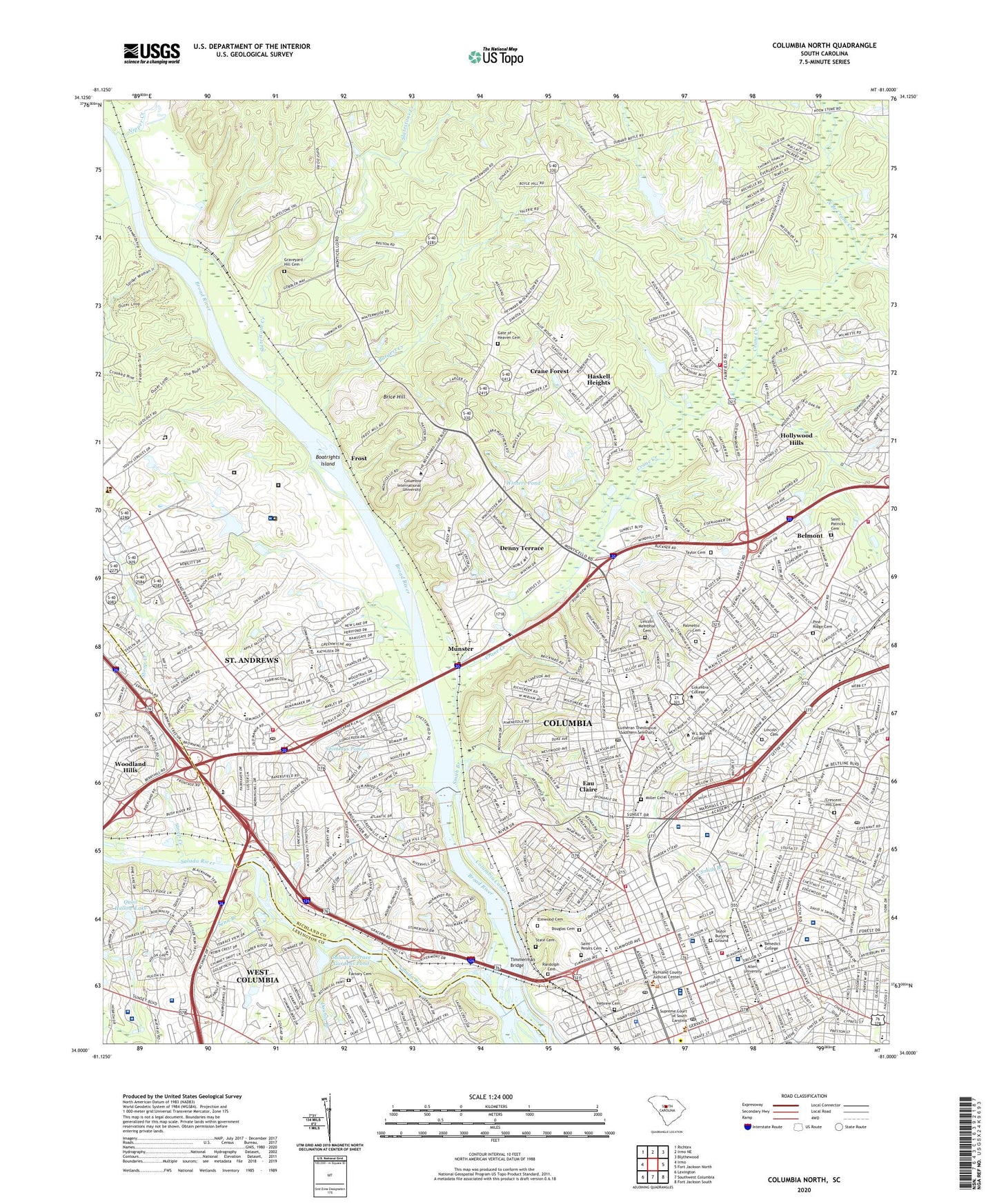
2024 topographic map quadrangle Columbia North in the state of South Carolina. Scale: 1:24000. Based on the newly updated USGS 7.5' US Topo map series, this map is in the following counties: Richland, Lexington. The map contains contour data, water features, and other items you are used to seeing on USGS maps, but also has updated roads and other features. This is the next generation of topographic maps. Printed on high-quality waterproof paper with UV fade-resistant inks.
Quads adjacent to this one:
West: Irmo
Northwest: Richtex
North: Irmo NE
Northeast: Blythewood
East: Fort Jackson North
Southeast: Fort Jackson South
South: Southwest Columbia
Southwest: Lexington
This map covers the same area as the classic USGS quad with code o34081a1.
Contains the following named places: Alcorn Dam D-0244, Alcorn Middle School, Allen Benedict Court, Allen University, Apple Valley, Arden Elementary School, Arlington Estates, Barhamville Estates, Barony, Baronywood, Belleview, Belmont, Belmont Estates, Benedict College, Benedict College Historic District, Boatrights Island, Booker Washington Heights, Boozer Shopping Center, Brice Hill, Broad River, Broad River Estates, Brockington Heights, Brook Pines, Burgess Creek, Burton School, Bush River Mall Shopping Center, Butchertown, Byrneswood, Carver School, Charter Rivers Hospital, Chartwell, Colonial Heights, Columbia, Columbia Bible College, Columbia Canal, Columbia College, Columbia Commercial College, Columbia Eye Surgery Center, Columbia Gastrointestinal Endoscopy Center, Columbia High School, Columbia Historic District I, Columbia Historic District II, Columbia Hospital, Columbia Male Academy, Columbia Power Plant Dam, Columbia Reservoir, Columbia Water Reservoir Dam, Crane Creek, Crane Creek School, Crane Forest, Crescent Hill Cemetery, Cross Roads, Denny Terrace, Denny Terrace Elementary School, Deporres School, Double Branch, Douglas Cemetery, Douglass Mill, Drew Park, Dreyfus Quarry, Dry Fork Creek, Dunston Hills, Dutch Square, Dutch Square Shopping Center, Dutchbrook, Earlwood Park, Eau Claire, Eau Claire High School, Eau Claire Park, Elm Abode, Elmwood, Elmwood Cemetery, Elmwood Park Historic District, Emerald Valley, Evergreen Park, Factory Cemetery, Fairfield Arms, Fairfield Terrace, Fairwold School, Five Points Shopping Center, Flake Hill School, Forest Hills, Frost, Gate of Heaven Cemetery, Gilliam Psychiatric Hospital, Gonzales Gardens Shopping Center, Good Samaritan Waverly Hospital, Graveyard Hill Cemetery, Haskell Heights, Healthsouth Rehabilitation Hospital of Columbia, Hebrew Cemetery, Heyward Gibbes Middle School, Highland Forest, Hollywood Hills, Homewood Terrace, Howard School, Hyatt Park School, Hyatts, Intermedical Hospital of South Carolina, Irwin Park, Jaggers Terrace, Johnson High School, Juvenile Corrections School, Kingswood, Kirkland Correctional Institution Infirmary, Latimer Manor, Lexington Medical Center, Lexington Medical Center Heliport, Lexington Medical Mall, Lincoln Cemetery, Lincoln Memorial Cemetery, Lincolnshire, Lincolnshire Community Lake D-0544 Dam, Logan School, Long Branch, Main Line Ditch, Mandel Hall, Mandel Park, Market Place Shopping Center, Marshall Park, Martin Luther King Jr. Park, McCants School, McMaster School, Meadow Lake, Melrose Heights, Midland Shopping Center, Midlands Orthopaedics Surgery Center, Miller Cemetery, Mission School, Munster, Nance School, Nicholas Creek, Nipper Creek, North Branch Crane Creek, North Columbia Quarry, North Twenty One Terrace, Northgate, Northway Plaza Shopping Center, Outlet Pointe Shopping Center, Palmer College, Palmetto Cemetery, Palmetto Center Heliport, Palmetto Health Baptist Hospital, Palmetto Richland Memorial Hospital, Park Place West, Pilgrim School, Pine Forest, Pine Grove School, Pine Ridge Cemetery, Pine Valley, Pinehurst Park, Power Pool, Providence Hospital, Providence Hospital Heliport, Quail Hollow, Quail Hollow Lake, Quail Hollow Lake Number One, Quail Hollow Lake Number One Dam D-4009, Quail Hollow Lake Number Two Dam D-4010, Randolph Cemetery, Reeves and Wades Mill, Richardson Plaza Shopping Center, Richland Memorial Hospital Heliport, Ridgewood Camp, Ridgewood School, Riverbanks, Riverbanks Zoo, Riverside Forest, Riverview Terrace, Rockgate, Saint Andrews, Saint Andrews Census Designated Place, Saint Andrews Middle School, Saint Andrews Shopping Center, Saint Patricks Cemetery, Saint Peters Cemetery, Saint Peters School, Saluda Factory Historic District, Saluda Gardens, Saluda Hills, Saluda River, Saluda River Estates, Saluda Terrace, Saluda Terrace Gardens Pond, Sarah Matthew School, Saxton Homes, Seaboard Park, Senn Branch, Shimmys Pond, Slatestone Creek, Smith Branch, South Carolina Endoscopy Center, South Carolina Medical Endoscopy Center, South Carolina Noname 32043 D-0984 Dam, South Carolina Noname 40047 D-0543 Dam, South Carolina Noname 40092 D-0542 Dam, South Carolina State Hospital, State Cemetery, Stoop Creek, Sunset Shopping Center, Taylor Burying Ground, Taylor Cemetery, Temple Zion School, Timmerman Bridge, Urology Surgery Center, Virginia Pack Elementary School, W A Perry Middle School, W G Sanders Middle School, WAAS-FM (Columbia), Walden Correctional Institution, Wardlaw Junior High School, Waverly, Waverly Historic District, Waverly Sanitarium, Waverly School, WBAJ-AM (Blythewood), WCOS-AM (Columbia), West Chester, Westover Acres, Westwood Hills, Widewater Shopping Center, Willow Lane Treatment Center Infirmary, Winters Pond, Withers School, WMFX-FM (Saint Andrews), WMHK-FM (Columbia), WOMG-AM (Columbia), WOMG-FM (Columbia), WQXL-AM (Columbia), WSCQ-FM (West Columbia), WUSC-FM (Columbia), WYYS-FM (Cayce), ZIP Codes: 29203, 29204, 29210