MyTopo
Lancaster South Carolina US Topo Map
Couldn't load pickup availability
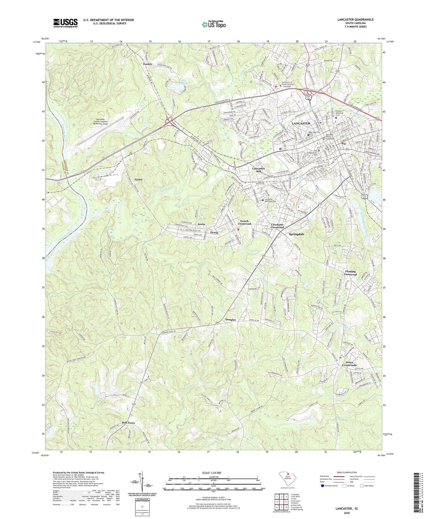
2024 topographic map quadrangle Lancaster in the state of South Carolina. Scale: 1:24000. Based on the newly updated USGS 7.5' US Topo map series, this map is in the following counties: Lancaster, Chester. The map contains contour data, water features, and other items you are used to seeing on USGS maps, but also has updated roads and other features. This is the next generation of topographic maps. Printed on high-quality waterproof paper with UV fade-resistant inks.
Quads adjacent to this one:
West: Fort Lawn
Northwest: Catawba
North: Van Wyck
Northeast: Unity
East: Antioch
Southeast: Heath Springs
South: Lancaster SE
Southwest: Great Falls
This map covers the same area as the classic USGS quad with code o34080f7.
Contains the following named places: Barr Street School, Bear Creek, Bell Town, Bell Town School, Bethel Church, Brooklyn Avenue School, Brooklyn Spring School, Calvary Church, Camp Creek, Camp Creek Church, Camp Creek School, Cane Creek, Caskey, Catawba Church, Catawba School, Cauthen-Clinton Center School, Cedar Pines Lake, Cedar Pines Lake D-1761 Dam, Cedar Terrace, Central School, Chesterfield School, Christ Church, Church of Christ, Church of God, City of Lancaster, Clinton Memorial Cemetery, Clinton School, Cloisters, Cooper Pond Dam D-1760, Country Club Heights, Crestview Church, Crocketts Crossroad, Dodson School, Douglas, Douglas Presbyterian Church, Douglass School, Eastside Church, Elliot White Springs Hospital Heliport, Erwin, Erwin Elementary School, Erwinwood Acres, First Associate Reformed Presbyterian Church, First Baptist Church, First Pentecostal Holiness Church, First Presbyterian Church, First United Methodist Church, Fleming Crossroad, Franklin Academy, Gills Creek, Gooch Crossroad, Gooch's Crossroads Fire Department Station 8, Good Shepherd Church, Grace, Grace Church, Green Peach Orchard, Greenbriar, Gregwood, H R Rice School, Hannahs Creek, Holiness Church, Immanuel Baptist Church, Irwin, Irwin Census Designated Place, Johnson Ford, Jones Cross Roads School, Jones Crossroads, Lancaster, Lancaster City Fire Department Station 1, Lancaster City Fire Department Station 2, Lancaster City Hall, Lancaster Country Club, Lancaster County Airport-McWhirter Field, Lancaster County Courthouse, Lancaster County Jail, Lancaster County Library, Lancaster County Memorial Stadium, Lancaster County Vocational School, Lancaster Division, Lancaster Downtown Historic District, Lancaster Memorial Park, Lancaster Mill, Lancaster Mill Census Designated Place, Lancaster Police Department, Lancaster Post Office, Lancaster Reservoir, Lancaster Senior High School, Lancaster Square Shopping Center, Lower Bell Town School, Lynwood United Methodist Church, Marion Sims Memorial Hospital, McDonald Green School, McDonald Green Volunteer Fire Department Station 12, Mount Moriah Church, Mount Zion Church, Murray Pond Dam D-1759, Nebo Church, North Junior High School, North Lancaster School, North Park Square Shopping Center, Northside Mission Church, Old City Reservoir D-1763 Dam, Old Presbyterian Cemetery, Pleasant Ridge Church, Red Hill Church, Reformation Lutheran Church, Rum Creek, Saint Paul African Methodist Episcopal Church, Santarosa, Second Avenue Church, Second Baptist Church, Sherwood Acres, Sherwood Church, South 200 Shopping Center, South Junior High School, Southside School, Springdale, Springdale Census Designated Place, Springdale Church, Springdell Church, Springs Memorial Hospital, Springs School, Starmount Acres, Temple Church, Trinity Church, Turkey Quarter Creek, University Baptist Church, University of South Carolina Extension Colle, Upper Bell Town School, Wade Memorial Church, Washington Baptist Church, West Manor, West Side Cemetery, Westgate Shopping Center, Westside Church, Westwood, White Springs Church, Zion African Methodist Episcopal Church