MyTopo
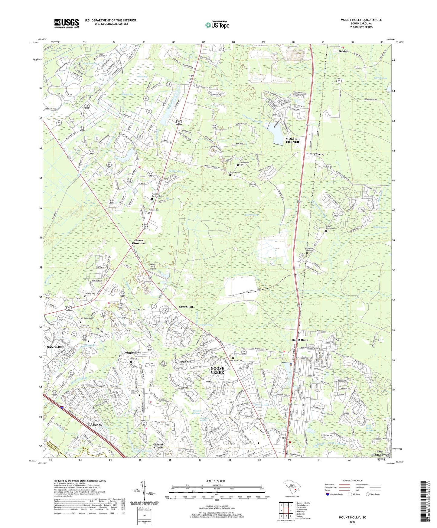
Mount Holly South Carolina US Topo Map
Couldn't load pickup availability
2020 topographic map quadrangle Mount Holly in the state of South Carolina. Scale: 1:24000. Based on the newly updated USGS 7.5' US Topo map series, this map is in the following counties: Berkeley, Charleston. The map contains contour data, water features, and other items you are used to seeing on USGS maps, but also has updated roads and other features. This is the next generation of topographic maps. Printed on high-quality waterproof paper with UV fade-resistant inks.
Quads adjacent to this one:
West: Summerville
Northwest: Summerville NW
North: Moncks Corner
Northeast: Cordesville
East: Kittredge
Southeast: North Charleston
South: Ladson
Southwest: Stallsville
Contains the following named places: Ancrum Swamp, Berkeley County Library Goose Creek Branch, Berkeley Square Shopping Center, Bethel Church, Bethel School, Beverly Hills, Boulder Bluff, Boulder Bluff Elementary School, Brick Bound Swamp, Calvary Church, Cane Bay Elementary School, Cane Bay High School, Canterhill Swamp, Carnes Crossroad, Caromi Fire Department, Caromi Village, Casey Church, Casey Community Center, Casey Hill, Casey School, Chaparral Ranches, Chapel of Our Savior, Cherry Hill Church, Christian Church, Church Hill, College Park, College Park Elementary School, College Park Middle School, Colonial Heights, Crowfield Golf and Country Club, Daisy Swamp, Devon Forest Elementary School, Driggerstown, Ellory Swamp, Fairfax, Forest Acres, Fox Bank, Foxborough, Gailmoor, Gants Mill Branch, Goose Creek Baptist, Goose Creek Cemetery, Goose Creek City Fire Department Fire Station 1, Goose Creek Community Center, Goose Creek Fire Department Station 2, Goose Creek Police Department, Goose Creek Rural Fire Department Station 2, Goose Creek-Hanahan Division, Groomsville Baptist Church, Groomsville Cemetery, Groomville, Groomville School, Grove Hall, Grove Hall Church, Grove Hill School, Hickory Hill, Highland Village, Holly Court, Hope Graded School, Hound Run, Huckhole Swamp, Huff Cemetery, King Branch, Ladson Census Designated Place, Lake Satko, Lake Wood, Laurel Swamp, Limehouse Branch, Lindley Branch, Moncks Corner Fire Department Station 3, Mount Holly, Mount Holly Airport, Mount Holly Commerce Park, New Hope Church, Oakatee, Oakley, Oakley Careers Center, Oakley Lookout, Oakley School, Pear Cemetery, Persimmon Hill, Pine Forest, Pine Forest School, Pine Ridge Fire Department Station 1, Pine Ridge Rural Volunteer Fire Department Devon Forest Station 3, Pine Ridge Rural Volunteer Fire Department Pine Ridge Station 1, Pine Ridge School, Pinewood House, Plantation Gardens Cemetery, Poplar Branch, Providence Church, Ridge Baptist Church, Ridge Cemetery, Saint Johns, Saint Johns Bethel Baptist Church, Salem Baptist Church, Salem Cemetery, Sangaree Elementary School, Sangaree Intermediate School, Sangaree Middle School, Scott Whaley Lake, Seaton, Shannon Park, Smyrna Cemetery, Smyrna Church, Sophia Swamp, South Carolina Noname 08032 D-3468 Dam, South Carolina Noname 08033 D-3474 Dam, South Carolina Noname 08041 D-0037 Dam, South Carolina Noname 08042 D-3469 Dam, South Carolina Noname 08046 D-3477 Dam, Stratford Forest, Stratford High School, Strawberry, Stroberfield Branch, Tall PInes, The Droze Cemetery, Tillmans Bay, Tillmans Branch, Varner School, Wassamasaw State Designated Tribal Statistical Area, Westview Elementary School, Westview Middle School, Whispering Pines Cemetery, Whites Bay, Whitesville Fire Department Station 2, Wide Awake, Williams Cemetery, Windwood, WJYQ-FM (Moncks Corner), WKCL-FM (Ladson), Woodland Heights