MyTopo
Stallsville South Carolina US Topo Map
Couldn't load pickup availability
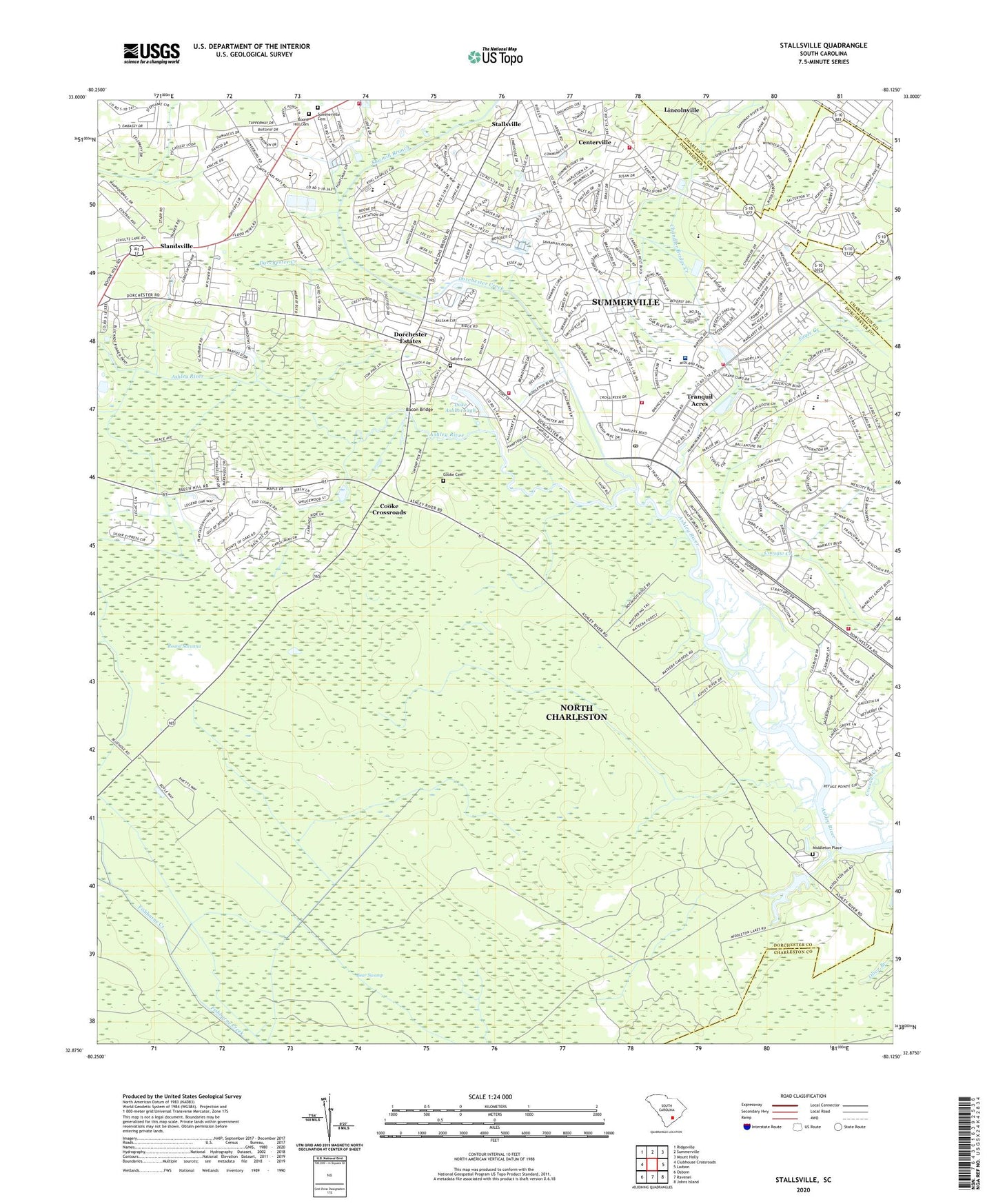
2020 topographic map quadrangle Stallsville in the state of South Carolina. Scale: 1:24000. Based on the newly updated USGS 7.5' US Topo map series, this map is in the following counties: Dorchester, Charleston. The map contains contour data, water features, and other items you are used to seeing on USGS maps, but also has updated roads and other features. This is the next generation of topographic maps. Printed on high-quality waterproof paper with UV fade-resistant inks.
Quads adjacent to this one:
West: Clubhouse Crossroads
Northwest: Ridgeville
North: Summerville
Northeast: Mount Holly
East: Ladson
Southeast: Johns Island
South: Ravenel
Southwest: Osborn
Contains the following named places: Ashborough, Ashborough East, Ashley Forest, Ashley Retreat, Ashley Ridge High School, Ashley River Church, Avenue of Oaks, Bacon Bridge, Barney Ridge, Beautiful Savior Lutheran Church, Beech Hill Elementary School, Boone Hill Cemetery, Boone Hill Church, Briarwood, Burbage Hunt Club, Calomet Valley, Camp Gregg, Campbell Hill Church, Centerville, Chandler Bridge Creek, Chandler Lakes, Chandler Village, Church of Christ, Cooke Cemetery, Cooke Crossroads, Coosaw Creek, Country Club Estates, Coventry Place, Creekside, Crestwood, Crichton Parish, Dorchester, Dorchester Congregational Church Ruins, Dorchester County Fire Department Dorchester Road Station 23, Dorchester County Fire Department Ladsen Station 21, Dorchester County Fire Department Miles Road Station 22, Dorchester County Public Library Summerville Branch, Dorchester Crossing, Dorchester Estates, Dorchester Village Shopping Center, Eagle Creek, Eagle Creek Shopping Center, Emmanuel Church, Evergreen, Fairlawn Terrace, Farmdale, First Southern Methodist Church of Summerville, Flowertown Elementary School, Flowertown Village, Fort Dorchester Elementary School, Grace Lutheran Church, Greenhurst, Gregg Middle School, Gregg School, Greggs Landing, Indian Springs, Iron Gate, Jamison Terrace, Kings Grant, Kings Grant Golf Club, Knightsville School, Ladson Oakbrook Shopping Center, Lake Ashborough, Lake Ashborough Dam D-2553, Laurel Hill, Legends Golf Club, Lowcountry Outpatient Surgery Center, Marlin Estates, Mateeba Gardens, Middleton Gardens, Middleton Hunt Club, Middleton Place, Miles Road Baptist Church, Moss Point, Newington Elementary School, Newington Plantation, Newington Swamp, North Charleston Fire Department Station 11, North Trident Baptist Church, Oakbrook, Oakbrook Community Church, Oakbrook Elementary School, Oakbrook Middle School, Oakbrook Shopping Center, Oakbrook Square Shopping Center, Oakdale Estates, Oakmont, Old Fort Baptist Church, Old Fort Dorchester, Old Fort Dorchester State Historical Park, Old Fort Estates, Olive Branch Church, Paper Maker Hunt Club, Plantation Ridge, Prudential Coosaw Creek Country Club, Quail Arbor, Round Savanna, Saint George Church Ruins, Saint Lukes Church, Saint Theresa Catholic Church, Salisbury Acres, Salters Cemetery, Sawmill Branch, Scots Kirk Associate Reformed Presbyterian Church, Slandsville, South Carolina Noname 10010 Dam, Southern Palms, Sprucewood, Stallsville, Stallsville School, Stallsville United Methodist Church, Summerville Cemetery, Summerville Country Club, Summerville Division, Summerville Farms, Summerville Fire Department Station 2, Summerville Fire Department Station 3, Summerville Galleria Phase I, Summerville High School, Summerville High-Gregg Camp School, Summerville Lookout Tower, Summerville Medical Center, Summerville Place, Summerville Plaza, Summerville Wastewater Treatment Facility, Summerville Water Plant, Summerwood, Summit Church, The Church of Jesus Christ of Latter Day Saints, The Gazebo School, Tranquil Acres, Tranquil Estates, Waters Edge, West Oaks, Westoe, White Church Place, Wood Oak Park, Woodland Estates, Woodlawn, WWWZ-FM (Summerville), WYFH-FM (North Charleston), ZIP Code: 29485