MyTopo
Sumter East South Carolina US Topo Map
Couldn't load pickup availability
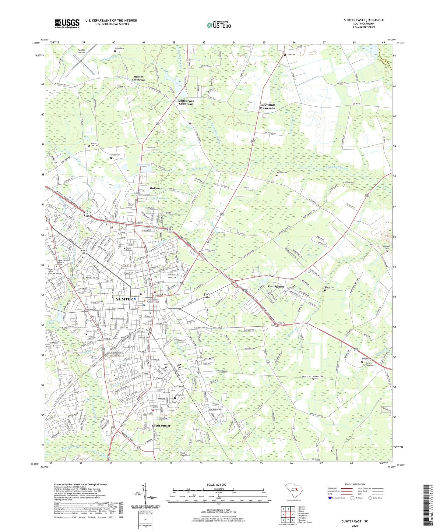
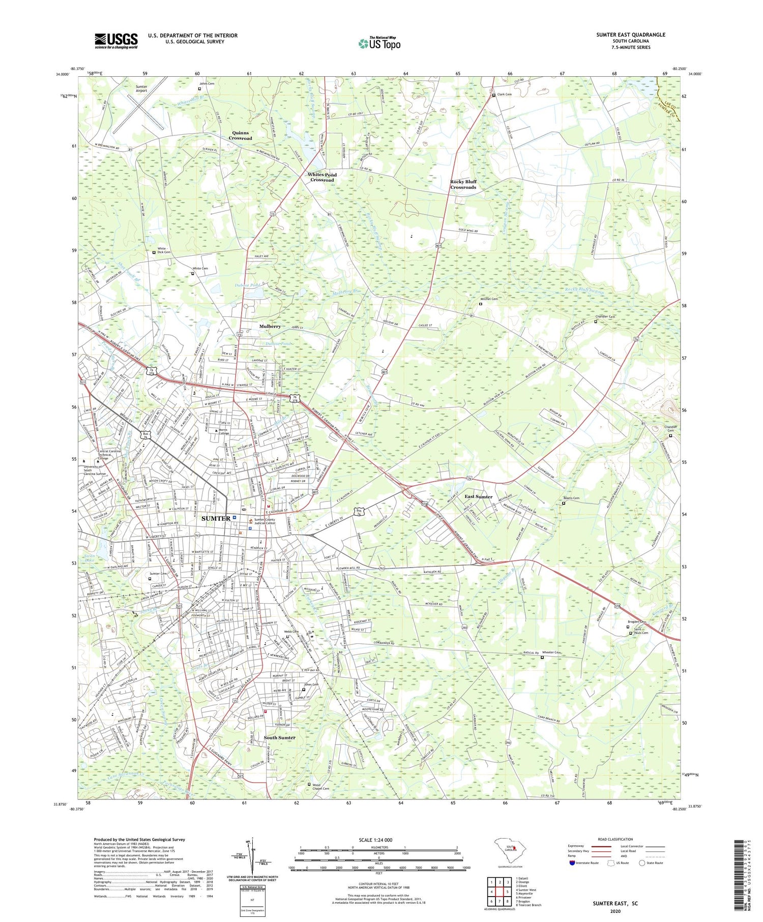
2020 topographic map quadrangle Sumter East in the state of South Carolina. Scale: 1:24000. Based on the newly updated USGS 7.5' US Topo map series, this map is in the following counties: Sumter, Lee. The map contains contour data, water features, and other items you are used to seeing on USGS maps, but also has updated roads and other features. This is the next generation of topographic maps. Printed on high-quality waterproof paper with UV fade-resistant inks.
Quads adjacent to this one:
West: Sumter West
Northwest: Dalzell
North: Oswego
Northeast: Elliott
East: Mayesville
Southeast: Tearcoat Branch
South: Brogdon
Southwest: Privateer
Contains the following named places: Archdale, Baker School, Bates School, Bethel African Methodist Episcopal Church, Bethlehem Baptist Church, Bible Fellowship Church, Birnie Center, Brady Heights, Brogden Cemetery, Brown Chapel, Brunson Branch, Burns Down, Cane Savannah Creek, Carnegie Public Library, Carolina Gardens, Carolina MedCare Ambulance, Cedar Grove Church, Central School, Chandler Cemetery, Chandler School, Church of God, Church of the Good Shepherd, Church of the Holy Comforter, Clark Cemetery, Clark Church, Clark School, Clinton Chapel African Methodist Episcopal Zion Church, Club Forest, Colonial Square Shopping Center, Concord Estates, Cowpen Swamp, Crosswell Drive Park, Crosswell Home, Crosswell School, Dubose Pond, Dubose Pond Dam D-1442, East Sumter, East Sumter Census Designated Place, Eastside Baptist Church, Eastwood Park, Edmunds High School, Emmanuel United Methodist Church, First Baptist Church, First Christian Church, First Church of the Nazarene, First Presbyterian Church, Flowers Heights, Folsom Park, Forest Heights, Forest Hills, Garris Park, Gatewood Park, Geddie Gardens, Golden Acre Mobile Home Park, Grace Baptist Church, Green Acres, Green Swamp, Greenwood, Guignard Park, Guignard Park East, Hampton School, Huntington, Iris Gardens, Iris Heights, Ivey Hall, Jefferson Park, Jehovah Baptist Church, Jenkins Center, Jessamine Mall Shopping Center, Johns Cemetery, Jones Cemetery, Julia Lester Dillon Park, Kingman Heights, Lafayette Heights, Lazy Acres Estates, Leawood, Lemira School, Liberty Street School, Lincoln High School, Lincoln Public Library, Little League Park, Marigold Heights, McIver School, McLaurin Junior High School, Midfield, Midland Acres, Mile Branch, Mitchel Cemetery, Moore School, Morris College, Moses Heights, Mount Moriah Church, Mount Pisgah African Methodist Episcopal Church, Mulberry, Mulberry Branch, Mulberry Census Designated Place, New Calvary Baptist Church, New Hope Church, Noyts Branch, Oaklawn, Palmetto Health Tuomey, Palmetto Plaza Shopping Center, Pentecostal Holiness Church, Pine Acres, Pinedale, Pinehurst, Pocalla Springs Golf Course, Powder Horn Branch, Quinns Chapel, Quinns Chapel School, Quinns Crossroad, Ranchland Ranchettes, Reams Cemetery, Richwood, Riley Field, Rocky Bluff Crossroads, Runnymeade, Saint Anne School, Saint Annes Roman Catholic Church, Saint James Lutheran Church, Saint John Church, Saint Johns United Methodist Church, Saint Jude Catholic Church, Saint Jude School, Saint Marks Church, Saint Marks United Methodist Church, Saint Pauls Cemetery, Saint Pauls Church, Salem Avenue Baptist Church, Salem Baptist Church, Saltertown School, Savage Glover School, Second Presbyterian Church, Seventh Day Adventist Church, Shannontown, Shaws Crossroads, Shepherd Church, Sherwood Forest, Shot Pouch Branch, Sooks Branch, South Carolina Highway Patrol Troop 1 Post A, South Carolina National Guard Headquarters, South Sumter, South Sumter Census Designated Place, Stone Hill School, Stonehill Special School, Summers Homes, Sumter, Sumter Airport, Sumter Area Technical College, Sumter Cemetery, Sumter City Hall, Sumter County Correctional Center, Sumter County Courthouse, Sumter County Emergency Medical Services, Sumter County Health Center, Sumter County Jail, Sumter County Library, Sumter County Rural Fire Department Station 521, Sumter Division, Sumter Female Institute, Sumter Fire Department Headquarters Station, Sumter Fire Department Manning Road Station, Sumter Historic District, Sumter Industrial Park, Sumter Northeast Division, Sumter Police Department, Sumter Post Office, Sumter Square Shopping Center, Sumter Waterworks, Sunset Country Club, Swan Lake, Swan Lake Dam D-1447, Swan Lake Gardens, Swan Lake Presbyterian Church, Temple Sinai, Tiller Circle, Tram Road School, Trinity Baptist Church, Trinity United Methodist Church, Union Station African Methodist Episcopal Church, University of South Carolina-Sumter, Walnut Hills, Washington School, WDXY-AM (Sumter), Webb Cemetery, Wen-le, Wheeler Cemetery, White - Dick Cemetery, White Cemetery, Whites Mill Branch, Whites Millpond, Whites Millpond Dam D-1988, Whites Pond Crossroad, Wilder School, Williams-Brice Museum, Willow Drive School, Winn School, Wolf Bay School, Wood Chapel Cemetery, WQMX-AM (Sumter), WRJA-FM (Sumter), WRJA-TV (Sumter), WSSC-AM (Sumter), Zion Baptist Church, ZIP Code: 29153