MyTopo
Walhalla South Carolina US Topo Map
Couldn't load pickup availability
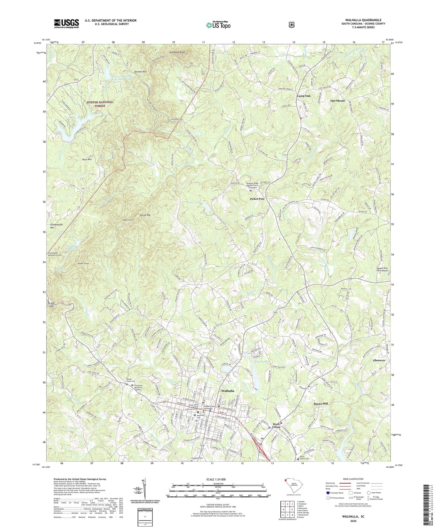
2020 topographic map quadrangle Walhalla in the state of South Carolina. Scale: 1:24000. Based on the newly updated USGS 7.5' US Topo map series, this map is in the following counties: Oconee. The map contains contour data, water features, and other items you are used to seeing on USGS maps, but also has updated roads and other features. This is the next generation of topographic maps. Printed on high-quality waterproof paper with UV fade-resistant inks.
Quads adjacent to this one:
West: Whetstone
Northwest: Satolah
North: Tamassee
Northeast: Salem
East: Old Pickens
Southeast: Seneca
South: Westminster
Southwest: Holly Springs
Contains the following named places: Alexander Creek, Beaty Creek, Bethel Church, Bethel Presbyterian Church Graveyard, Bookers Lake, Bookers Lake Dam D-1646, Browns Lake, Burns Mill, Calvary Church, Camp Oak, Church of God, City of Walhalla, College Street Baptist Church, Colonial Heights, Crystal Falls, Dutch Fork, Eastcliff, Ebenezer, Ebenezer Baptist Church, Ebenezer High School, Emmanuel Church, Evergreen Memorial Gardens, Fairfield School, First Baptist Church, Flat Rock Baptist Church, Flat Rock Cemetery, Flat Shoals, Forest Acres, Galilee Methodist Episcopal Church, Hi Saw Gap, Isaqueena Falls, Lake Becky, Lee Branch, Little Cane Creek, Middle Tunnel, Mountain Lake Dam D-1641, Mountain Spring Church, Mountain Springs Baptist Church Graveyard, Neville School, New Galilee Baptist Church, Oakmont, Oconee County, Oconee County Courthouse, Oconee County Jail, Oconee County Library, Oconee Creek School, Oconee Mountain, Oconee State Park, Oconee State Park Dam Number One D-1642, Oconee State Park Lake Number One, Oconee Station, Oconee Station School, Picket Post, Pickett Post Camp Oak Volunteer Fire Department, Pickett Post Office, Pine Street Elementary School, Piney Grove Cemetery, Pleasant Ridge Baptist Church, Pleasant Ridge Baptist Church Graveyard, Reece Branch, Rocky Ford, Rocky Knoll Baptist Church, Rocky Knoll Cemetery, Ross Mountain, Saddle Tunnel, Saint Francis Catholic Church, Saint Johns Evangelical Lutheran Church, Saint Johns Evangelical Lutheran Church Cemetery, Scenic Plaza Shopping Center, South Carolina Noname 37011 D-1651 Dam, South Carolina Noname 37031 D-1643 Dam, Springdale, Station Creek, Station Creek Cove Botanical Area, Stumphouse Mountain, Tamassee Knob, Town of West Union, Trinity Methodist Church, Turnip Top, Victor Monaghan School, Walhalla, Walhalla City Hall, Walhalla Division, Walhalla Elementary School, Walhalla Fire Department Oconee County Station 5, Walhalla Graded School, Walhalla High School, Walhalla Methodist Church, Walhalla Middle School, Walhalla Police Department, Walhalla Post Office, Walhalla Presbyterian Church, Walhalla Reservoir, Walhalla Reservoir Dam D-1647, Walhalla Wesleyan Methodist Church, Welcome Wesleyan Church, West Union, West Union Fire Department Oconee County Rural Unit 16, West Union Police Department, West Union Post Office, Westview Cemetery, Williams Creek, Woodland Trailer Park, Yellow Branch Lookout Tower, Zion Church, ZIP Codes: 29691, 29696