MyTopo
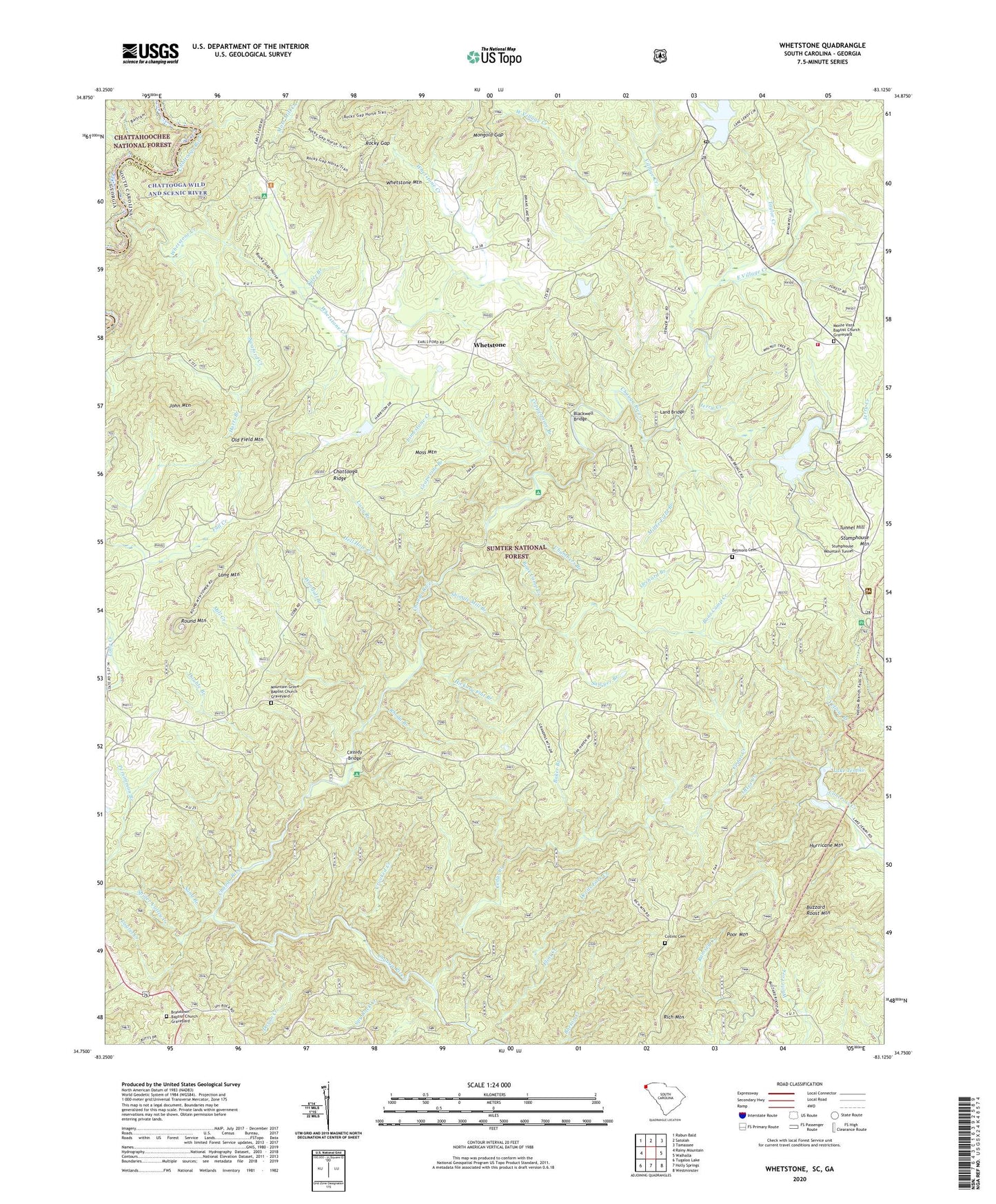
Whetstone South Carolina US Topo Map
Couldn't load pickup availability
Also explore the Whetstone Forest Service Topo of this same quad for updated USFS data
2024 topographic map quadrangle Whetstone in the states of South Carolina, Georgia. Scale: 1:24000. Based on the newly updated USGS 7.5' US Topo map series, this map is in the following counties: Oconee, Rabun. The map contains contour data, water features, and other items you are used to seeing on USGS maps, but also has updated roads and other features. This is the next generation of topographic maps. Printed on high-quality waterproof paper with UV fade-resistant inks.
Quads adjacent to this one:
West: Rainy Mountain
Northwest: Rabun Bald
North: Satolah
Northeast: Tamassee
East: Walhalla
Southeast: Westminster
South: Holly Springs
This map covers the same area as the classic USGS quad with code o34083g2.
Contains the following named places: Andrew Pickens Ranger Station, Baker Branch, Belmont Baptist Church, Belmont Cemetery, Bethlehem School, Blackwell Bridge, Bone Camp Creek, Brasstown Baptist Church, Brasstown Baptist Church Graveyard, Buzzard Roost Mountain, Cassidy Bridge, Cassidy Bridge Campground, Cedar Creek, Cedar Creek Rifle Range, Chambers Branch, Chattooga School, Chauga River Scenic Area, Collins Cemetery, Coppermine Branch, Crooked Creek, Crystal Lake, Crystal Lake Dam D-1645, Dicks Creek, Doran Creek, Double Branch, Double Springs Baptist Church, Double Springs Church, Double Springs Methodist Church Graveyard, East Village Creek, Flint Creek, Grapevine Branch, Harts Branch, Hell Hole Creek, Hickory Flat Branch, Hurricane Mountain, Jerry Creek, John Mountain, Lake Jemike, Lake Jemike Number One Dam D-1648, Lake Jemike Number Two Dam D-1649, Lake Leroy, Lake Leroy Dam D-1639, Land Bridge, Laurel Creek, Limestone Creek, Long Branch, Long Creek Academy, Long Creek Division, Long Creek Lookout Tower, Long Creek School, Long Mountain, Mill Creek, Miller Field Branch, Mongold Gap, Monte Vista Baptist Church, Monte Vista Baptist Church Graveyard, Moss Mountain, Mountain Grove Baptist Church, Mountain Grove Baptist Church Graveyard, Mountain Grove School, Mountain Rest, Mountain Rest Baptist Church, Mountain Rest School, Oconee County Emergency Services Mountain Rest Fire Station 4, Old Field Mountain, Orchard Branch, Orrs Mill Creek, Otter Creek, Poor Mountain, Poplar Springs School, Rhoda Branch, Rich Mountain, Rich Mountain School, Rock Creek, Rocky Gap, Round Mountain, Round Mountain Church, Round Mountain School, Sand Branch, Sandy Ford, Sawyer Branch, Shingle Mill Branch, South Carolina Noname 37030 D-1644 Dam, Spider Valley Creek, Spy Rock Creek, Stumphouse Mountain Tunnel, Swaford Creek, Taylor Creek, Tunnel Hill, Tyler Branch, Village Creek, West Village Creek, Whetstone, Whetstone Creek, Whetstone Mountain, Woodall Branch, Yellow Branch, Yellow Branch Campground, ZIP Code: 29664