MyTopo
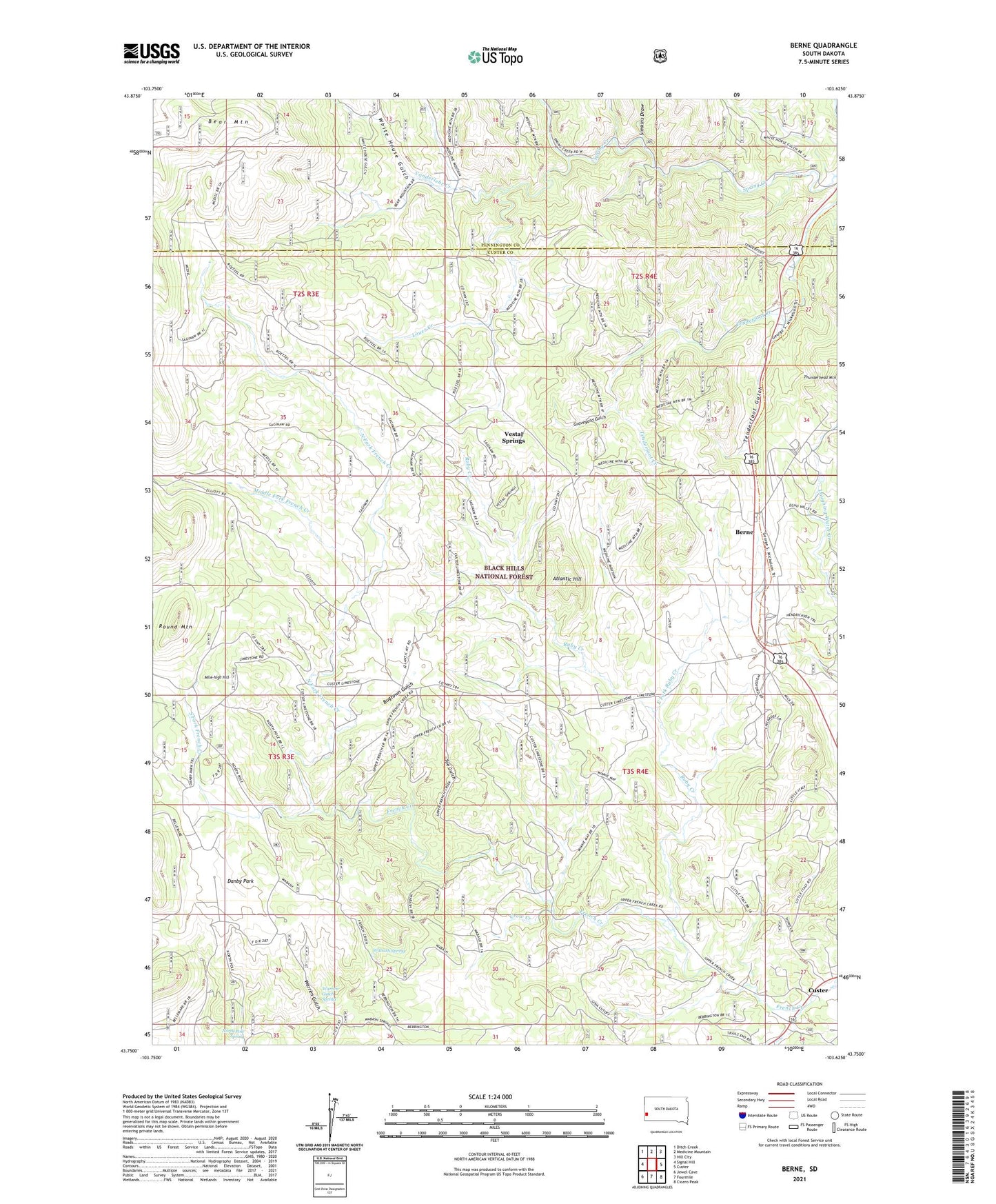
Berne South Dakota US Topo Map
Couldn't load pickup availability
Also explore the Berne Forest Service Topo of this same quad for updated USFS data
2021 topographic map quadrangle Berne in the state of South Dakota. Scale: 1:24000. Based on the newly updated USGS 7.5' US Topo map series, this map is in the following counties: Custer, Pennington. The map contains contour data, water features, and other items you are used to seeing on USGS maps, but also has updated roads and other features. This is the next generation of topographic maps. Printed on high-quality waterproof paper with UV fade-resistant inks.
Quads adjacent to this one:
West: Signal Hill
Northwest: Ditch Creek
North: Medicine Mountain
Northeast: Hill City
East: Custer
Southeast: Cicero Peak
South: Fourmile
Southwest: Jewel Cave
This map covers the same area as the classic USGS quad with code o43103g6.
Contains the following named places: Atlantic Hill, Ballard Mine, Bear Mountain, Bear Mountain Lookout, Belmores Ranch, Berne, Big Spar Number 1 Mine, Black Diamond Mine, Bugtown, Bugtown Gulch, Butte Group Mine, Camp Custer, Camp Custer Dam, Cheyenne Lode Mine, Crazy Post Office, Crow Creek, Crown Mine, Danby Park, Danoby, Deacon Wright Lode Mine, Dorothy Lode Mine, Dorothy Number 1 Lode Mine, Dorothy V Prospect Mine, East Fork Ruby Creek, Echo Lode Mine, Forahs Ranch, Forty-Five Lode Mine, Friday Lode Mine, Gold Fish Group Mine, Golden Crown Mine, Grand Junction and Hartford Group Mine, Graveyard Gulch, High Climb Mine, Highland Lode, Highview Prospect, Independence Lode Mine, Independence Number 1 Lode Mine, Junction Ranger Station, Kirka Claim Mine, Laughing Water Creek, Loues Creek, Louise and Hunter Mine, Lucky Bird Lode Mine, McKinney Ranch, McMackin Mine, Middle Fork French Creek, Mile-high Hill, Minnie May Mine, Naiad Queen Lode Mine, Newark Group Mine, North Fork French Creek, North Pole Spring, North Star Mine, Occidental Lode Mine, Old Bill Mine, Old Jeff Mine, Park School, Penobscott Mine, Raver and Michaud Mine, Ridge Lode Mine, Roetzel Deer Camp, Ross Mine, Rough Rider Mine, Round Mountain, Ruby Creek, Saginaw Mine, Sally Cavanaugh Mine, Saw Lode Mine, Simkins Draw, South Fork French Creek, Sunrise Lode Mine, Sunset Lode Mine, Tenderfoot, Tenderfoot Group Mine, Tenderfoot Gulch, Tin Reef, Toe Gulch, Turk Group Mine, Vanderlehr Creek, Vanderlehrs Ranch, Vestal Springs, Wabash Mine, Wabash Spring, Warren Gulch Spring, Western Star Mine, White Dog Mica Mine, White House Gulch, Wilhelm Mine, Zimbleman Deer Camp