MyTopo
Ausmus Tennessee US Topo Map
Couldn't load pickup availability
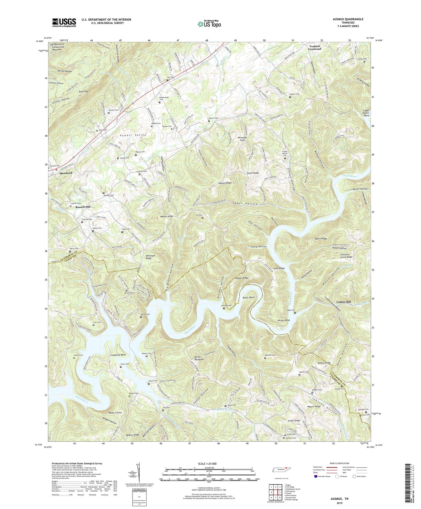
2019 topographic map quadrangle Ausmus in the state of Tennessee. Scale: 1:24000. Based on the newly updated USGS 7.5' US Topo map series, this map is in the following counties: Claiborne, Union. The map contains contour data, water features, and other items you are used to seeing on USGS maps, but also has updated roads and other features. This is the next generation of topographic maps. Printed on high-quality waterproof paper with UV fade-resistant inks.
Quads adjacent to this one:
West: Well Spring
Northwest: Eagan
North: Fork Ridge
Northeast: Middlesboro South
East: Clouds
Southeast: Powder Springs
South: Maynardville
Southwest: White Hollow
Contains the following named places: Ausmus Cemetery, Ausmus Hollow, Bean Hollow, Beech Grove Cabin Area, Beeler Cemetery, Big Branch, Big Branch Hollow, Bolinger Cemetery, Bolinger School, Bostic Bend, Braden Hollow, Branscombe Cemetery, Brogan Cemetery, Bunch Hollow, Cain Cemetery, Caldwell Mine, Calloway Hollow, Camp Creek, Caney Hollow, Capps Cemetery, Capps Creek, Capps Creek Church, Capps Creek School, Capps Crossing, Capps Ford, Capps Hollow, Carr Branch, Carr Cemetery, Carr Chapel, Chestnut Grove Ridge, Chestnut Grove School, Civilian Conservation Corps Camp TVA Number 13, Clawson Cemetery, Coles Mill, Collins Mill, Commissioner District 8, Cooper Ridge, Davis Creek Church, Devils Backbone, Dry Hollow, Dunn Cemetery, Dunn Gap, Edwards Cemetery, Ellison Cemetery, Fortner Branch, Friendship Church, Greasy Hollow, Greasy Hollow Cemetery, Happy Hollow, Harmon Cemetery, Haynes Ridge, Hill Cemetery, Hunter Cemetery, Jones Ridge, Keck Cemetery, Kelly Hollow, Lay Cemetery, Leach Cemetery, Leadmine Bend, Leadmine Bend Creek, Leatherwood Church, Leatherwood Hollow, Leatherwood School, Leech Ford, Longmire Church, Lower Fall Branch, Lundy Cemetery, Mattox Hollow, Mell Fall Hollow, Monks Corner, Monks Corner TVA Small Wild Area, Moyers Cemetery, New Prospect, New Prospect Mine, New Salem Church, Norton Cemetery, Odom Hollow, Pierce Cemetery, Pine Grove Church, Pleasant, Pleasant Hill Church, Proffit Hollow, Pump Hollow, Rogers Cemetery, Rogers Gap, Rollins Ridge, Rush Strong School, Russell Branch, Russell Cemetery, Russell Mill, Shady Grove Church, Sharp Hollow, Shipley Grove Church, Shipley School, Shoffner Cemetery, Smith Ridge, Speedwell, Speedwell Volunteer Fire Department Station 1, Steiners Fishing Camp, Stiner Cemetery, Stiner Dock, Stiner Prospects, Stiner Ridge, Stiner Store, Stiners Woods TVA Small Wild Area, Stinnat Hollow, Straight Branch, Straight Branch Dock, Sugar Hollow, Taylor Cemetery, Taylor Grove Church, Tony Hollow, Treece Cemetery, Upper Fall Branch, Wagon Hollow, Weaver Cemetery, Weaver Knob, Weaver Ridge, Welch Ridge, Whiteoak Church, Whiteoak Flats, Whiteoak Ridge, Williams Cemetery, Williams Hollow, Williams Mill, Wilson Bend, Wilson Cemetery, Yellow Branch, Yoakum Crossroad, ZIP Code: 37870