MyTopo
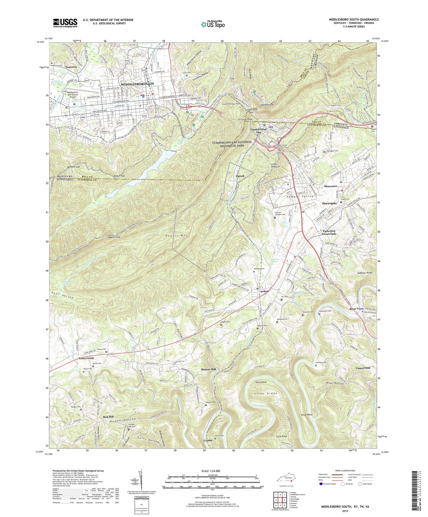
Middlesboro South Kentucky US Topo Map
Couldn't load pickup availability
2022 topographic map quadrangle Middlesboro South in the states of Tennessee, Kentucky, Virginia. Scale: 1:24000. Based on the newly updated USGS 7.5' US Topo map series, this map is in the following counties: Bell, Claiborne, Lee. The map contains contour data, water features, and other items you are used to seeing on USGS maps, but also has updated roads and other features. This is the next generation of topographic maps. Printed on high-quality waterproof paper with UV fade-resistant inks.
Quads adjacent to this one:
West: Fork Ridge
Northwest: Kayjay
North: Middlesboro North
Northeast: Varilla
East: Wheeler
Southeast: Tazewell
South: Clouds
Southwest: Ausmus
Contains the following named places: ARH Heliport, Arthur, Arthur Dam, Arthur Lake, Arthur Post Office, Arthur School, Arthur United Methodist Church, Ball Cemetery, Baptist Gap, Bell County Rescue Squad, Bennett Gap, Bennetts Fork, Blair Hollow, Blairs Creek, Bruce Cemetery, Bruce Prospect, Butchers Spring, Calvary Church, Carr Hollow, Cemetery Hollow, Chumley Cemetery, City of Harrogate, City of Middlesborough, Cline Knob, Cline Ridge, Combs, Combs Station Prospect, Commissioner District 7, Cottrell - Johnson Cemetery, Cumberland Gap, Cumberland Gap Police Department, Cumberland Gap Post Office, Cumberland Gap Tunnel, Cumberland Gap Volunteer Fire Department, Cumberland Mountain, Davis Branch, Davis Station, Dead Horse Hollow, Dunlap Hollow, Earls Hollow, Ellen Meyers Elementary School, Ely Cemetery, Fern Lake, First Baptist Church of Harrogate, Flatwood Chapel, Fort McCook, Gap Creek, Gap Creek Church, Gap Creek Prospect, Gardner Prospect, Gobblers Knob, Grantham Cemetery, Grantham Ford, Happy Hollow, Harrogate, Harrogate Cemetery, Harrogate City Volunteer Fire Station 2, Harrogate Post Office, Harrogate United Methodist Church, Harrogate Volunteer Fire Department Station 1, Hensley Cemetery, Hooper Cemetery, Jordan Branch, Keg Branch, Keg Branch School, Kibert Cemetery, Kings Bend, Kings Bend Mine, Landmark Church, Lewis Hollow, Lincoln Memorial University, Little Pinnacle, Little Tunnel, Little Yellow Creek, Livesay Middle School, Lynch Cemetery, Madon Hollow, Marsee Cemetery, McNew Cemetery, Middlesboro, Middlesboro ARH Hospital, Middlesboro Fire Department Station 1, Middlesboro Fire Department Station 2, Middlesboro Police Department, Middlesboro Post Office, Middlesboro-Bell County Airport, Miller Chapel, Minton Mill, Minton Prospect, Mockingbird Mobile Home Park, Old Red Hill Cemetery, Old Town Creek School, Otey Mill Spring, Parker Branch, Parker Gap, Patterson Crossroads, Pine Hill Hollow, Poor Valley, Poore Cemetery, Powell Mountain, Powell Valley Church, Providence Church, Providence School, Pump Springs Church, Pump Springs Mobile Home Park, Red Hill, Red Hill Missionary Baptist Church, Red Hill Number Two School, Ridge Trail, River View, Riverview Missionary Baptist Church, Rowland Cemetery, Saint Julians School, Scott Cemetery, Shawanee, Shawanee Baptist Church, Shawanee Post Office, Shawanee School, Sproles Chapel School, Stony Fork, Summey Bridge Church, Templin Pond, The Doublings, The Doublings Branch, The Pinnacle, Tiprell, Tiprell School, Town Creek, Town Creek Church, Town of Cumberland Gap, Treece Cemetery, Tri-State Peak, Underwood Grove Church, Underwood School, Union College Environmental Education Center, Vancel Mill, Water Prong, Water Tank, Welch Cemetery, West End School, WFXY-AM (Middlesboro), Woodson Cemetery, WSVQ-AM (Harrogate), Wylie Bend, Yellow Branch, ZIP Code: 37724