MyTopo
Clouds Tennessee US Topo Map
Couldn't load pickup availability
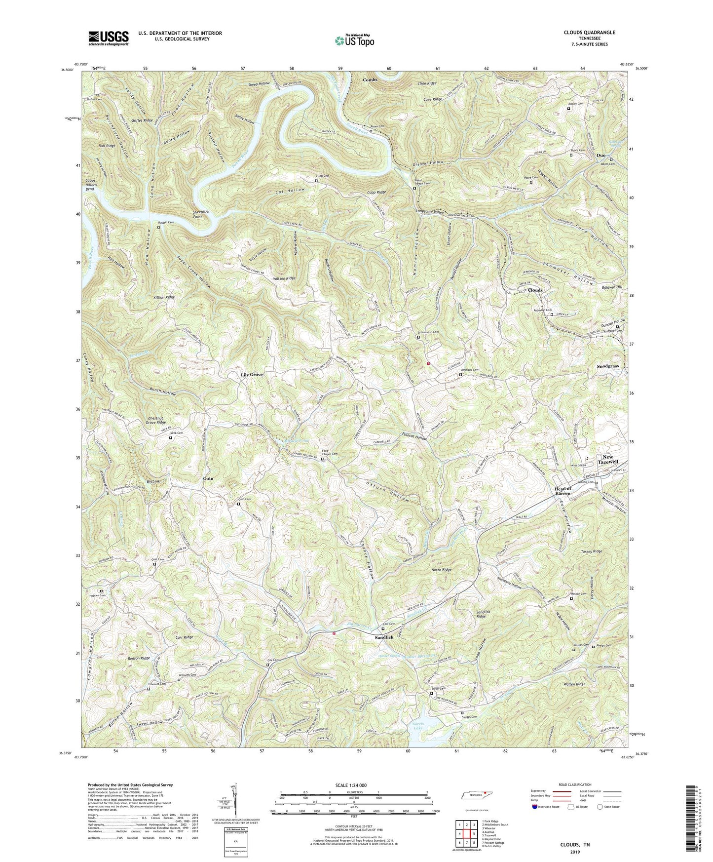
2022 topographic map quadrangle Clouds in the state of Tennessee. Scale: 1:24000. Based on the newly updated USGS 7.5' US Topo map series, this map is in the following counties: Claiborne, Union. The map contains contour data, water features, and other items you are used to seeing on USGS maps, but also has updated roads and other features. This is the next generation of topographic maps. Printed on high-quality waterproof paper with UV fade-resistant inks.
Quads adjacent to this one:
West: Ausmus
Northwest: Fork Ridge
North: Middlesboro South
Northeast: Wheeler
East: Tazewell
Southeast: Dutch Valley
South: Powder Springs
Southwest: Maynardville
This map covers the same area as the classic USGS quad with code o36083d6.
Contains the following named places: Bailey Hollow, Beasons Store, Big Barren, Big Barren Creek Church, Big Barren Creek Division, Big Sink, Bull Ridge, Bunch Hollow Mine, Bunchs Store, Bunky Hollow, Burch Cemetery, Burchfield Hollow, Burke Hollow, Capps Hollow Bend, Carr Branch, Carr Branch Church, Carr Cemetery, Carr Ridge, Cat Branch, Cat Hollow, Cave Ridge, Chance Hollow, Chestnut Grove Ridge, Civilian Conservation Corps Camp Number 19, Claiborne County, Claiborne County Landfill, Cline School, Clouds, Clouds Memorial Baptist Church, Clouds School, Cole Cemetery, Cole Hollow, Commissioner District 2, Cox Cemetery, Cupp Cemetery, Cupp Mill, Cupp Ridge, Cupp School, Daniel Hollow, Days Store, Drummond Cemetery, Duncan Hollow, Duo, Edmondson, Edwards Cemetery, Edwards School, Flat Hollow, Ford Chapel Cemetery, Ford Hollow, Fords Chapel Methodist Church, Fortner Branch Prospect, Goin, Goin Cemetery, Goins Chapel, Greaver Hollow, Hall Hollow, Hamlet Hollow, Hauser Spring, Hauser Spring Branch, Head of Barren, Head of Barren Church, Head of Barren School, Hen Hollow, Hickory Hollow, Holt Cave Spring, Honeysuck Prospect, Hopper Cemetery, Hopper Hollow, Island Ford, Johnson Hollow, Keck Cemetery, Kecks Store, Killion Ridge, Kingdom Hall, Lily Grove, Lily Grove Missionary Baptist Church, Lily Grove School, Locust Grove School, Lonesome Valley, Lonesome Valley Creek, Lonesome Valley Elementary School, Long Hollow, Loop Hollow, Lundy Hollow, M C M Church, M C M School, Mathis Hollow, Mayes Cemetery, Mayes Chapel United Methodist Church, Mayes Mill, McBee Hollow, McNew Hollow, Meyer Grove Church, Meyers Branch, Meyers Cemetery, Meyers Mill, Minkton, Minton Cemetery, Minton Hollow, Miracle Pond, Moody Cemetery, Myers Store, New Hope Missionary Baptist Church, North Ridge, Old Town Creek, Oxford Hollow, Perry Hollow, Phelps Cemetery, Pleasant Point Primitive Baptist Church, Pleasant Point School, Polecat Hollow, Poore Cemetery, Powell River, Reason Ridge, Robinson Cemetery, Robinson Hollow, Russell Cemetery, Russell Ford, Russell Hollow, Sandlick, Sandlick Creek, Sandlick Ridge, Sandlick School, Sheep Hollow, Sheeplick Point, Sherman Hollow, Shiflet Cemetery, Shiflet Ridge, Short Hollow, Shumaker Cemetery, Shumaker Hollow, Simmons Cemetery, Simmons Chapel, Skaggs Cemetery, Slate Creek, Snodgrass, South Claiborne Volunteer Fire Department Station 41, South Claiborne Volunteer Fire Department Station 42, Stansbury Hollow, Still Branch, Straight Creek Boat Dock, Straight Creek Church, Straight Creek Mines, Straight Creek School, Sugar Creek Hollow, Sugar Grove Church, Sweet Hollow, Tuttle Hollow, Upper Straight Creek School, Water Treece Cemetery, Watson Chapel, Watson Ridge, Watson School, Williams Cemetery, ZIP Code: 37825