MyTopo
Fork Ridge Tennessee US Topo Map
Couldn't load pickup availability
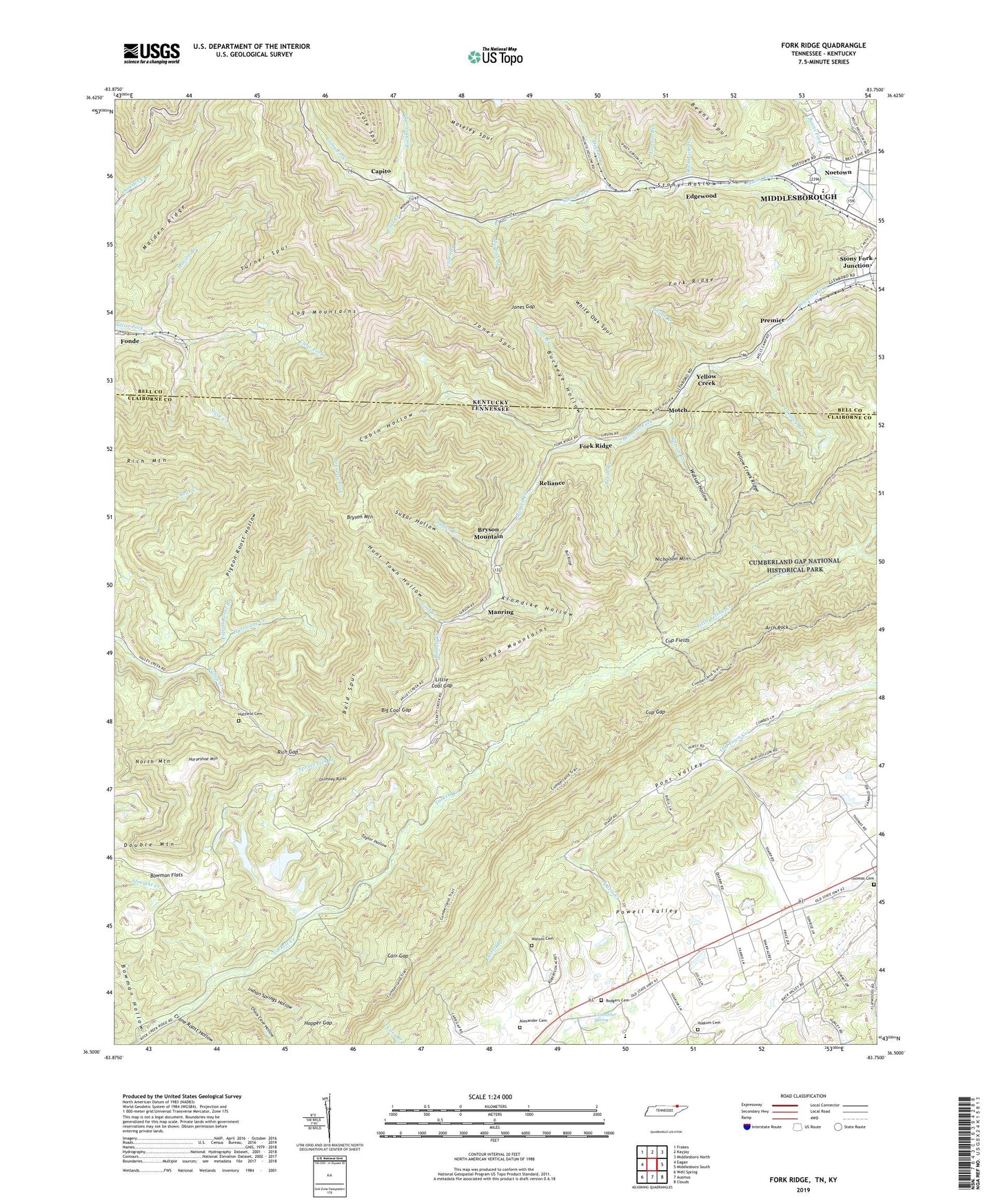
2022 topographic map quadrangle Fork Ridge in the states of Tennessee, Kentucky. Scale: 1:24000. Based on the newly updated USGS 7.5' US Topo map series, this map is in the following counties: Claiborne, Bell. The map contains contour data, water features, and other items you are used to seeing on USGS maps, but also has updated roads and other features. This is the next generation of topographic maps. Printed on high-quality waterproof paper with UV fade-resistant inks.
Quads adjacent to this one:
West: Eagan
Northwest: Frakes
North: Kayjay
Northeast: Middlesboro North
East: Middlesboro South
Southeast: Clouds
South: Ausmus
Southwest: Well Spring
This map covers the same area as the classic USGS quad with code o36083e7.
Contains the following named places: Alexander Cemetery, Arbor Railroad Station, Arch Rock, Bald Spur, Beans Fork, Beans Fork School, Beech Branch, Bennetts Fork Church, Big Coal Gap, Bosworth Post Office, Bosworth Railroad Station, Bosworth School, Bowman Flats, Bowman Hollow, Bryson Mountain, Buckeye Hollow, Bull Ridge, Burrell Creek, Cabin Creek, Cabin Hollow, Capito, Capito Post Office, Capito Railroad Station, Carr Gap, Chalk Cave Hollow, Chimney Rocks, Clairfield Division, Cloverleaf Railroad Station, Coal Creek, Congress Railroad Station, Consolidation Coal Water Supply Lake, Crane Roost Hollow, Cup Fields, Cup Gap, Dorland Railroad Station, Double Mountain, Edgewood, Edgewood Railroad Station, Erelaman Railroad Station, Fork Ridge, Fork Ridge Mine, Fork Ridge School, Fortner Branch, Glenboro Railroad Station, Gravity Railroad Yard, Hatfield Cemetery, Haynes Flat Church, Hignite Creek, Hopper Gap, Horseshoe Mountain, Hunt Town Hollow, Hurricane Creek, Indian Springs Hollow, Jones Branch, Jones Gap, Jones Spur, Kelos Railroad Station, Klondike Hollow, Langley Branch, Little Coal Gap, Log Mountains, Long Branch, Maiden Ridge, Manring, Marsee Branch, Martins Branch, Mingo Hollow, Mingo Mountains, Moffet Railroad Station, Mooneyham Mine, Motch, Mountain View United Methodist Church, Nicholson Mountain, Noetown, North Mountain, Olson Railroad Station, Paramount Railroad Station, Pigeon Roost Branch, Pigeon Roost Hollow, Poplar Lick Mine, Powell Valley, Powell Valley Division, Powell Valley Elementary School, Powell Valley High School, Premier, Reliance, Rich Gap, Rich Mountain, Richardson Chapel, Rising Spring Church, Rising Springs School, Rock Lick Branch, Rockhouse Branch, Rodgers Cemetery, Rook Railroad Station, Shade Branch, Slickrock Branch, Spruce Lick Branch, Spruce Lick Fresh Water Dam, Spruce Lick Slurry Refuse Dam, Spruce Lick Slurry Refuse Impound, Steve Creek, Stony Fork Junction, Stony Fork Railroad Station, Stony Hollow, Sues Branch, Sugan Branch, Sugar Hollow, Taylor Hollow, Thomas Cemetery, Turner Spur, Union School, Vanbebber Spring, Vowels Railroad Station, Watson Branch, Watson Cemetery, Watson Hollow, White Oak Spur, Wilmont Railroad Station, Winona Post Office, WMIK-FM (Middlesboro), Yellow Creek, Yellow Creek Ridge, Yoakum Cemetery, Yoakums Chapel Church of God