MyTopo
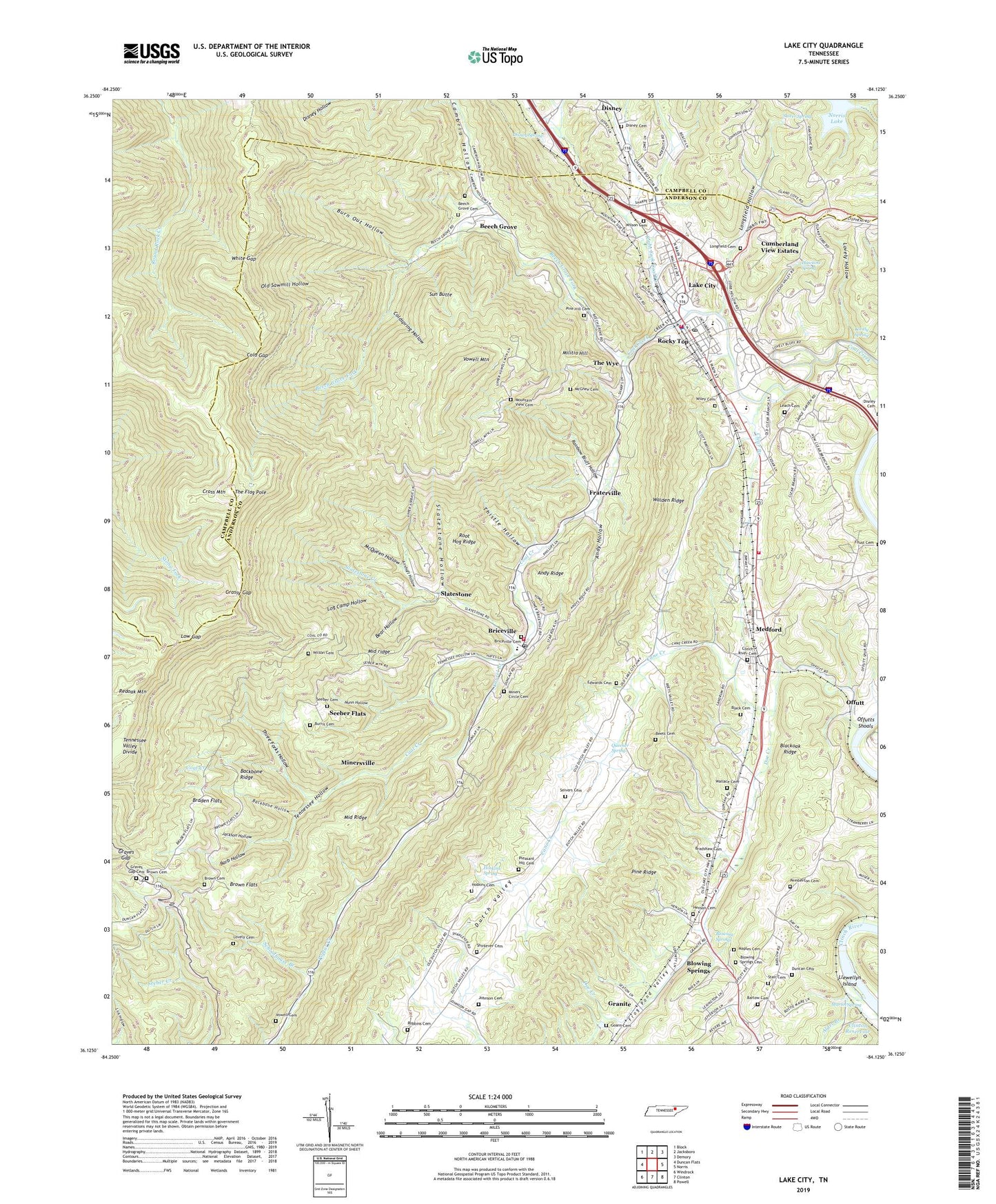
Lake City Tennessee US Topo Map
Couldn't load pickup availability
2022 topographic map quadrangle Lake City in the state of Tennessee. Scale: 1:24000. Based on the newly updated USGS 7.5' US Topo map series, this map is in the following counties: Anderson, Campbell. The map contains contour data, water features, and other items you are used to seeing on USGS maps, but also has updated roads and other features. This is the next generation of topographic maps. Printed on high-quality waterproof paper with UV fade-resistant inks.
Quads adjacent to this one:
West: Duncan Flats
Northwest: Block
North: Jacksboro
Northeast: Demory
East: Norris
Southeast: Powell
South: Clinton
Southwest: Windrock
This map covers the same area as the classic USGS quad with code o36084b2.
Contains the following named places: Airshaft Hollow, Alder Branch, Andy Hollow, Andy Ridge, Antioch Church, Backbone Hollow, Backbone Ridge, Barb Hollow, Barlow Cemetery, Bear Hollow, Beech Grove, Beech Grove Baptist Church, Beech Grove Cemetery, Beech Grove Fork, Beech Grove Mine, Beech Valley Mine, Beets Cemetery, Black Cemetery, Blowing Springs, Blowing Springs Baptist Church, Blowing Springs Cemetery, Blowing Springs School, Braden Flats, Braden School, Bradshaw Cemetery, Briceville, Briceville Census Designated Place, Briceville Elementary School, Briceville Methodist Church, Briceville Methodist Church Cemetery, Briceville Post Office, Briceville Volunteer Fire Department, Brown Cemetery, Brown Flats, Burn Out Hollow, Burris Cemetery, Byrge Chapel, Cambria Hollow, Cane Creek, City of Rocky Top, Clear Branch, Clear Branch Baptist Church, Clinch River Baptist Church, Clinch River Cemetery, Clinton Reservoir, Cold Gap, Coldspring Hollow, Cross Mountain, Cumberland View Estates, Disney, Disney Cemetery, Disney Spring, District 14, District 5, Doe Creek, Duncan Cemetery, Edwards Cemetery, Foust Cemetery, Fraterville, Goans Cemetery, Granite, Grassy Gap, Graves Gap, Graves Gap Baptist Church, Graves Gap Cemetery, Guiding Star Church, Hawkins Spring, Henson Cemetery, Hoskins Cemetery, Hoskins Spring, Hurstle Braden Mine, Indian Bluff Baptist Church, Indian Bluff Cemetery, Jackson Hollow, Johnson Cemetery, Knapp, Lake City Air Force Station, Lake City East Division, Lake City Elementary School, Lake City Middle School, Lake City West Division, Laurel Branch, Laurel Branch Baptist Church, Leach Cemetery, Llewellyn Island, Llewellyns Schoals, Log Camp Hollow, Longfield Baptist Church, Longfield Cemetery, Longfield Hollow, Lovely Branch, Lovely Cemetery, Lovely Hollow, Lovely Spring, Low Gap, Lowe and Brown Cemetery, Maples Cemetery, Martin Spring, McGhee Cemetery, McQueen Hollow, Medford, Medford Elementary School, Medford Station, Medford Volunteer Fire Department, Middle Creek, Middle ridge, Middle Ridge, Militia Hill, Miller Creek, Miners Circle Cemetery, Minersville, Minersville Church, Mountain View Baptist Church, Mountain View Cemetery, Norman School, Nunn Hollow, Offutt, Offutts Shoals, Old Sawmill Hollow, Pemberton Cemetery, Pine Hill Baptist Church, Pine Hill Cemetery, Pine Ridge Chapel, Pleasant Hill Baptist Church, Pleasant Hill Cemetery, Queener Spring, Rainbow Bluff Hollow, Right Fork Coal Creek, Robbins Cemetery, Rocky Top, Rocky Top Fire Department, Rocky Top Police Department, Rocky Top Post Office, Root Hog Ridge, Rush Strong School, Schoolhouse Branch, Seeber Flats, Seiber Cemetery, Seivers Cemetery, Shinlever Cemetery, Slatestone, Slatestone Creek, Slatestone Hollow, Slatestone Mine, Slover Spring, Stair Cemetery, Sun Butte, Swag Church, Tennessee Camp, Tennessee Hollow, Tennessee Hollow Church, The Flag Pole, The Wye, Thistle Hollow, Thistle Mine, Thomas Shoals, Three Forks Hollow, Valley View Church, Vowell Cemetery, Vowell Mountain, Vowell School, Walden View Church, Wallace Cemetery, White Gap, Wiley Cemetery, Willow Brook Baptist Church, Wilson Cemetery, WOKI-FM (Oak Ridge), ZIP Code: 37769