MyTopo
Bluff City Tennessee US Topo Map
Couldn't load pickup availability
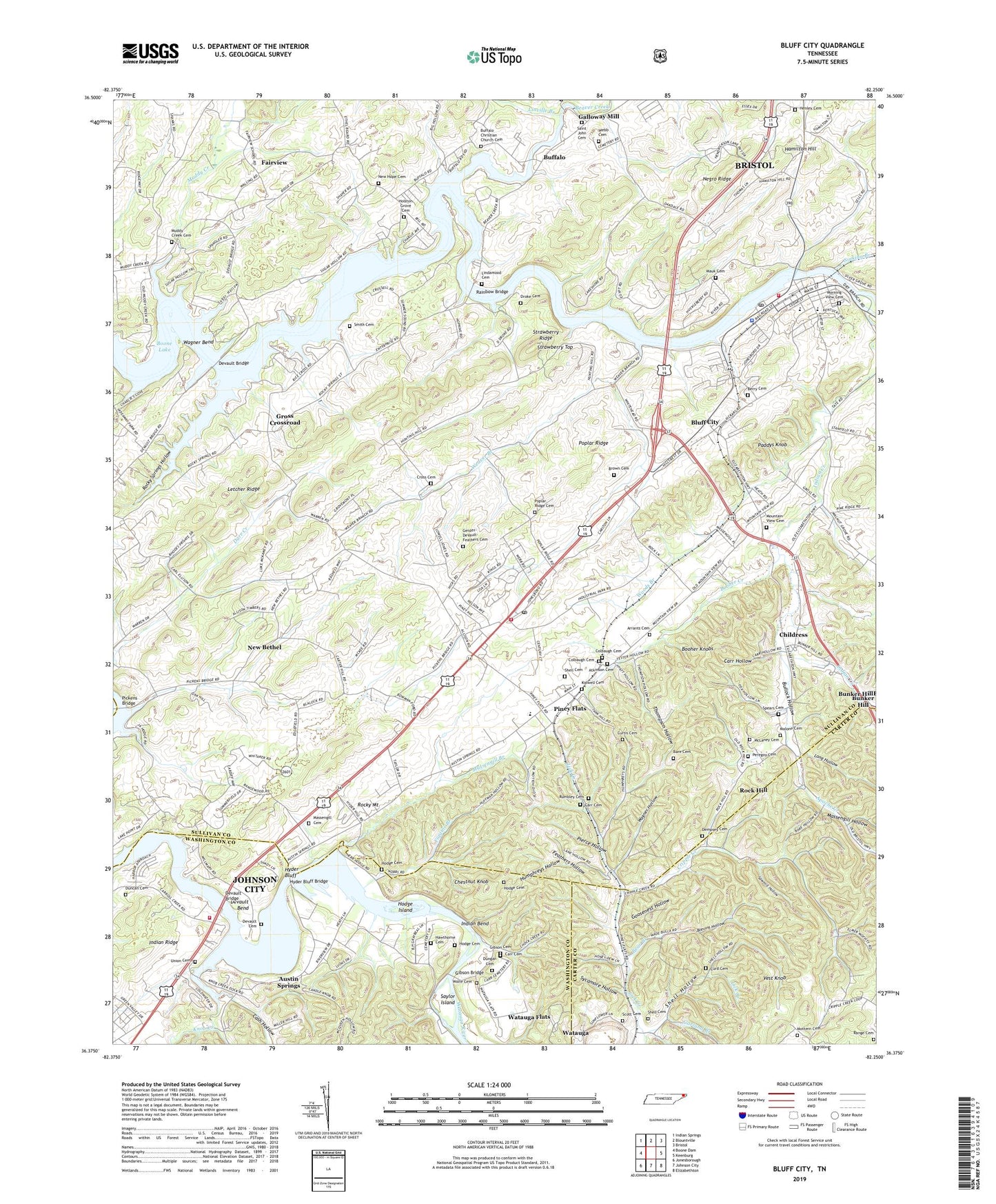
2019 topographic map quadrangle Bluff City in the state of Tennessee. Scale: 1:24000. Based on the newly updated USGS 7.5' US Topo map series, this map is in the following counties: Sullivan, Washington, Carter. The map contains contour data, water features, and other items you are used to seeing on USGS maps, but also has updated roads and other features. This is the next generation of topographic maps. Printed on high-quality waterproof paper with UV fade-resistant inks.
Quads adjacent to this one:
West: Boone Dam
Northwest: Indian Springs
North: Blountville
Northeast: Bristol
East: Keenburg
Southeast: Elizabethton
South: Johnson City
Southwest: Jonesborough
Contains the following named places: Allison Mill, Apache Creek, Arrants Cemetery, Atkinson Cemetery, Austin Springs, Austin Springs Elementary School, Bare Cemetery, Bear Branch, Bear Hollow, Beaver Creek, Beaver Creek Lower Forge, Berry Cemetery, Blevins Hollow, Bluff City, Bluff City Elementary School, Bluff City Middle School, Bluff City Police Department, Bluff City Post Office, Bluff City Volunteer Fire Department, Booher Creek, Booher Knobs, Boone Lake, Brown Cemetery, Buffalo, Buffalo Christian Church Cemetery, Buffalo Church, Buffalo School, Bullock Hollow, Carr Cemetery, Carr Hollow, Cash Hollow, Chestnut Knob, Childress, City of Bluff City, Cobb Creek, Colbaugh Cemetery, Commissioner District 5, Cripple Creek, Cross Cemetery, Curd Cemetery, Curtis Cemetery, Dempsey Cemetery, Devault Bend, Devault Bridge, Devault Cemetery, Devault Ford, Droke Cemetery, Duncan Cemetery, Dungan Cemetery, Edgefield Church, Enterprise Church, Enterprise School, Fairview, Fairview School, Feathers Hollow, Fickles Island, Figgins Branch, Galloway Mill, Garland Branch, Geisler-DeVault-Feathers Cemetery, Gibson Bridge, Gibson Cemetery, Goosenest Hollow, Green Valley, Gross, Gross Crossroad, Hamilton, Hamilton Hill, Harry Hollow, Hawthorne Cemetery, Hawthorne Church, Henley Cemetery, Hillcrest, Hodge Cemetery, Hodge Island, Hogan Branch, Holston Grove Cemetery, Holston Grove Church, Hulls Chapel, Humphreys Hollow, Hyder Bluff, Hyder Bluff Bridge, Hyder Mill, Indian Bend, Indian Creek, Island Park, Johnson City Fire Department Station 9, Kidwell Cemetery, Knob Creek, Knob Creek Boat Dock, Lella, Letcher Ridge, Lick Branch, Lick Creek Church, Lindamood Cemetery, Linville Branch, Locust Grove School, Long Hollow, Malone Cemetery, Mary Hughes High School, Massengill Branch, Massengill Cemetery, Massengill Hollow, Massengill Island, Mauk Cemetery, McLaney Cemetery, Morning View Cemetery, Mottern Cemetery, Mount Olive Church, Mount View Church, Mountain View Cemetery, Mountain View School, Muddy Creek, Muddy Creek Cemetery, Muddy Creek Church, Negro Ridge, New Bethel, New Hope Cemetery, New Hope Missionary Baptist Church, Oakdale Church, Oakdale School, Old Bloomary Forge, Paddys Knob, PCC Helipad, Peregoy Cemetery, Pickens Bridge, Pierce Hollow, Piney Flats, Piney Flats Church, Piney Flats Post Office, Piney Flats Siding, Piney Flats Volunteer Fire Department, Poplar Ridge, Poplar Ridge Cemetery, Poplar Ridge Church, Poplar Ridge School, Rainbow Bridge, Range Cemetery, Riverview Church, Rock Hill, Rock Hill School, Rocky Mount, Rocky Spring School, Rocky Springs, Rocky Springs Hollow, Rumbley Cemetery, S And D Mobile Home Park, Saint John Cemetery, Saint Paul Church, Sawmill Hollow, Saylor Island, Scott Cemetery, Shaver Mill, Shell Cemetery, Shell Hollow, Sinking Branch, Smith Cemetery, Spears Cemetery, Sportsman Dock, Stoney Cross Island, Strawberry Ridge, Sturgeon Ford, Sugar Hollow, Sumpter, Sycamore Hollow, Thom, Thompson Hollow, Tri-City Dock, Union Cemetery, Union Church, Vest Knob, Wagner Bend, Wagner Hollow, Walnut Grove Church, Watauga Flats, Watauga Flats School, Weaver Branch, Webb Cemetery, Wolfe Cemetery, Woods Branch, ZIP Codes: 37686, 37694