MyTopo
Cookeville West Tennessee US Topo Map
Couldn't load pickup availability
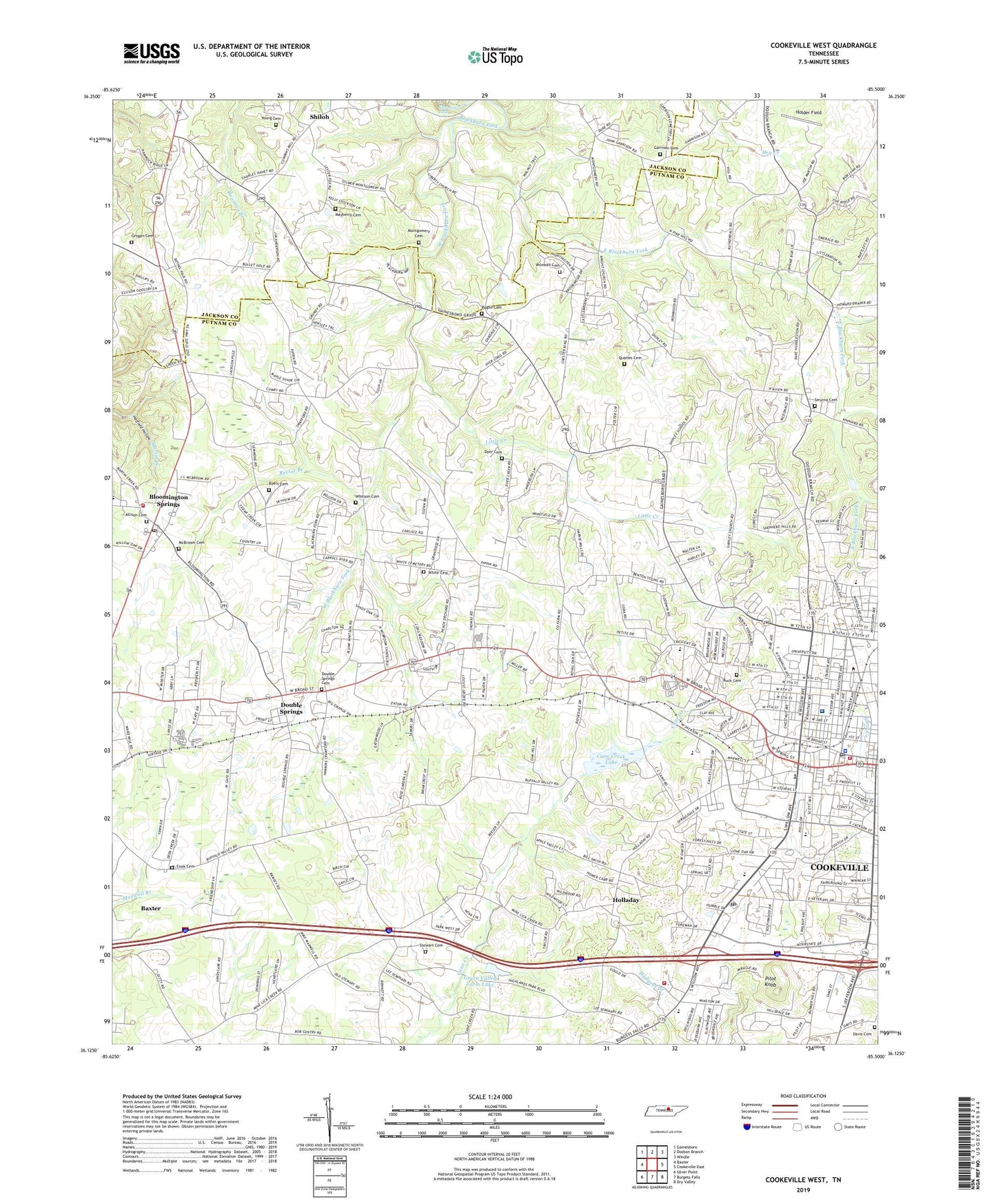
2019 topographic map quadrangle Cookeville West in the state of Tennessee. Scale: 1:24000. Based on the newly updated USGS 7.5' US Topo map series, this map is in the following counties: Putnam, Jackson. The map contains contour data, water features, and other items you are used to seeing on USGS maps, but also has updated roads and other features. This is the next generation of topographic maps. Printed on high-quality waterproof paper with UV fade-resistant inks.
Quads adjacent to this one:
West: Baxter
Northwest: Gainesboro
North: Dodson Branch
Northeast: Windle
East: Cookeville East
Southeast: Dry Valley
South: Burgess Falls
Southwest: Silver Point
Contains the following named places: Allison Cemetery, Apple Valley Estates, Arnolds Chapel, Blackburn Hills Estates, Bloomington Springs, Bloomington Springs Post Office, Bloomington Springs School, Bloomington Springs Statin, Brandywine Estates, Broad Street Station Post Office, Buck Cemetery, Byers Cemetery, Cane Creek Church, Cane Creek Lake, Cane Creek Park, Central Emmanuel Baptist Church, Central High School, City of Cookeville, College Heights, Colonial Acres, Commissioner District 10, Commissioner District 3, Commissioner District 6, Commissioner District 9, Cooke Cemetery, Cookeville, Cookeville Church of Christ, Cookeville City Hall, Cookeville Fire Department Station 1, Cookeville Fire Department Station 3, Cookeville First Baptist Church, Cookeville Mall Shopping Center, Cookeville Police Department, Cookeville Post Office, Cookeville Regional Medical Center, Cummins Falls, Cummins Mill Baptist Church, Darwin High School, Davis Cemetery, Deberry Heights, Double Springs, Double Springs Baptist Church, Double Springs Cemetery, Double Springs School, Dyer Cemetery, East Blackburn Fork, Ensor Park, First Assembly of God Church, First Church of the Nazarene, First Presbyterian Church, First United Methodist Church, Forest Hills, Garrison Cemetery, Grandiose Field, Green Acres, Green Hills, Green Valley Farm Lake, Green Valley Farm Lake Dam, Grogan Cemetery, Hillsdale, Holder Field, Holladay, Holladay Church, Holladay School, Honeybrook, Ironwood Golf Course, Jere Whitson Elementary School, Judd Church, Knight Chapel, Kuykendall Branch, Lee Seminary, Liberty Church, Little Creek, Locust Grove Church, Locust Grove School, Lone Oak Church, Long Meadows, Mayberry Cemetery, McBroom Cemetery, McBroom Chapel, Melrose, Montgomery Cemetery, Mount Vernon, Oak Grove Church, Oak Grove School, Oakdale, Oakland, Parkview Elementary School, Pilot Knob, Pippen Springs Estates, Pippin Cemetery, Pippin Church, Pippin School, Plateau Mental Health Center, Pleasant Valley Church, Post Oak Shade Church, Putnam County Fire Department Station 31, Putnam County Home, Putnam County Library, Putnam County Volunteer Fire Department, Quality Estates, Quarles Cemetery, Rector Branch, Rolling Meadows, Rose Garden Estates, Scott Avenue Baptist Church, Shepherd Hills, Sherwood Estates, Shiloh, Shiloh School, Shipley Church, Shipley School, Smyrna Cemetery, Smyrna Church, Springdale, Stevens Street Baptist Church, Stewart Cemetery, Sun Valley, Sycamore Church of Christ, Sycamore Elementary School, Tanglewood, Tara Estates, Tennessee Highway Patrol District Six Headquarters, Tennessee Polytechnic Institute, Towne Plaza Shopping Center, Union Chapel, Union Grove Church, West Blackburn Fork, West View Baptist Church, Westgate, WGSQ-FM (Cookeville), White Cemetery, Whitson Cemetery, WHUB-AM (Cookeville), Wildwood, Wilhite Church, Willow Tree Shopping Center, Wilmoth Cemetery, WPTN-AM (Cookeville), WTTU-FM (Cookeville), Young Cemetery, ZIP Codes: 38501, 38505