MyTopo
Dodson Branch Tennessee US Topo Map
Couldn't load pickup availability
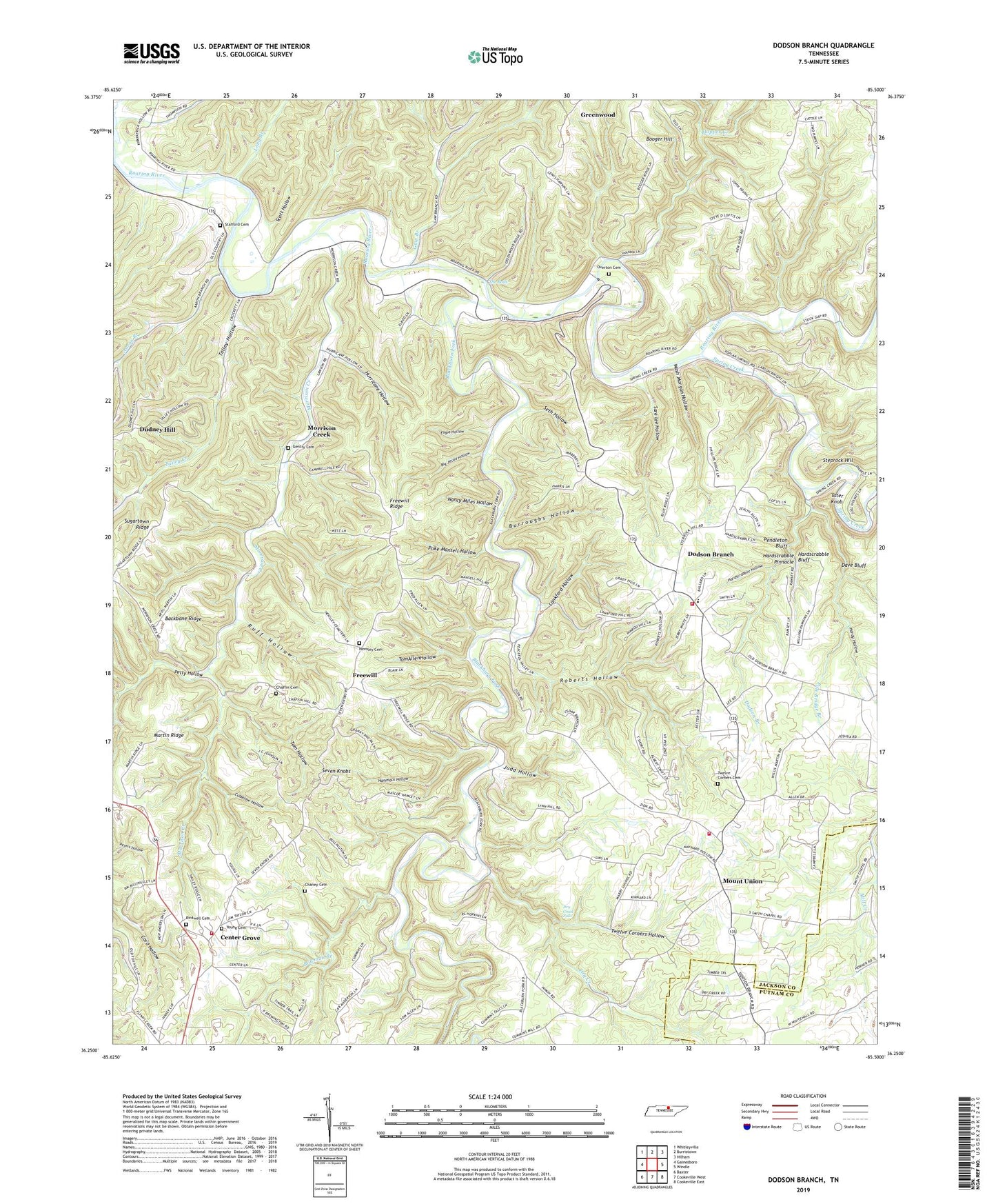
2022 topographic map quadrangle Dodson Branch in the state of Tennessee. Scale: 1:24000. Based on the newly updated USGS 7.5' US Topo map series, this map is in the following counties: Jackson, Putnam. The map contains contour data, water features, and other items you are used to seeing on USGS maps, but also has updated roads and other features. This is the next generation of topographic maps. Printed on high-quality waterproof paper with UV fade-resistant inks.
Quads adjacent to this one:
West: Gainesboro
Northwest: Whitleyville
North: Burristown
Northeast: Hilham
East: Windle
Southeast: Cookeville East
South: Cookeville West
Southwest: Baxter
This map covers the same area as the classic USGS quad with code o36085c5.
Contains the following named places: Aaron Branch, Arbor Church, Arbor School, Backbone Ridge, Big Jessie Hollow, Birdwell Cemetery, Blackburn Fork, Blackburn Fork State Scenic River, Booger Hill, Bowman Branch, Burroughs Hollow, Cedar Grove School, Center Grove, Center Grove School, Chaffin Cemetery, Chaney Cemetery, Commissioner District 3, Commissioner District 4, Cubelow Hollow, Cummins Mill, Dave Bluff, Dodson Branch, Dodson Branch Census Designated Place, Dodson Branch Church, Dodson Branch School, Dodson Branch Volunteer Fire Department, Dodson Branch Volunteer Fire Department Station 2, Dry Creek, Dry Creek Falls, Engia Hollow, Freewill, Freewill Church, Freewill Ridge, Freewill School, Gainesboro Division, Gaw Branch, Gentry Cemetery, Gentry School, Hammock Hollow, Hardscrabble Bluff, Hardscrabble Hollow, Hardscrabble Pinnacle, Hardy Hollow, Hensley Cemetery, Hopper Creek, Hurricane Hollow, Judd Hollow, Lankford Hollow, Long Branch, Lynn School, Maberry School, Martin Ridge, Masters Mill, Mayfield, Morrison Creek, Morrison Creek School, Mount Union, Mount Union Church, Nancy Miles Hollow, Overton Cemetery, Pacific, Peaks Mill, Pendleton Bluff, Petty Hollow, Pine Hill School, Poke Mansell Hollow, Pole Bridge Branch, Roaring River Mill, Roaring River State Scenic River, Roberts Hollow, Ruff Hollow, Sara Lee Hollow, Scott Hollow, Seth Hollow, Seven Knobs, Smith Chapel, South Side Volunteer Fire Department, Spring Creek, Spring Creek Church, Stafford Cemetery, Steprock Hill, Stony Point School, Sugartown Ridge, Talley Creek, Talley Hollow, Tater Knob, The Boils, Tom Allen Hollow, Tom Hollow, Twelve Corners Cemetery, Twelve Corners Church, Twelve Corners Hollow, Wash Morgan Hollow, Whiteacres Mill, Whitehall School, Woodrow School, Young Cemetery, Zion Church