MyTopo
Cookeville East Tennessee US Topo Map
Couldn't load pickup availability
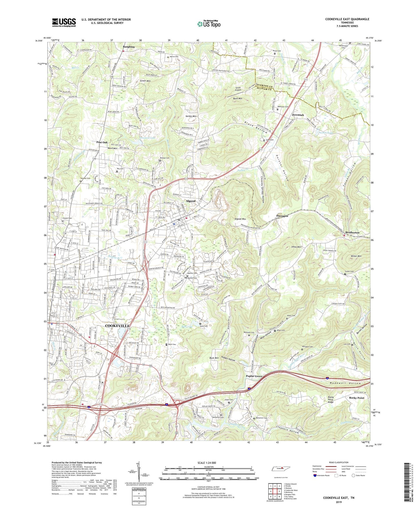
2022 topographic map quadrangle Cookeville East in the state of Tennessee. Scale: 1:24000. Based on the newly updated USGS 7.5' US Topo map series, this map is in the following counties: Putnam, Overton. The map contains contour data, water features, and other items you are used to seeing on USGS maps, but also has updated roads and other features. This is the next generation of topographic maps. Printed on high-quality waterproof paper with UV fade-resistant inks.
Quads adjacent to this one:
West: Cookeville West
Northwest: Dodson Branch
North: Windle
Northeast: Okalona
East: Monterey
Southeast: Monterey Lake
South: Dry Valley
Southwest: Burgess Falls
This map covers the same area as the classic USGS quad with code o36085b4.
Contains the following named places: Algood, Algood City Hall, Algood Community Center, Algood Elementary School, Algood Fire Department, Algood First Baptist Church, Algood Methodist Church, Algood Mountain, Algood Police Department, Algood Post Office, Algood Quarry, Bangham, Bangham Church, Bangham Heights Baptist Church, Bangham School, Barnes Hollow, Barnes Hollow Branch, Bear Creek Church, Belle Acres Golf Club, Beverly Hills, Bilbrey Park, Billburys Mill, Black Bottom, Bohannon Cemetery, Boles Branch, Briargate, Brotherton, Brotherton Baptist Church, Brotherton School, Brotherton United Methodist Church, Browne Airport, Buck Cemetery, Buck Lake, Buck Lake Estates, Buck Mountain, Buck Mountain Estates, Burton Cemetery, Burton Estates, Burtons Branch, Burtons Chapel, Calvary Baptist Church, Candyland Estates, Capshaw Elementary School, Capshaw Woods, Chimney Springs Hollow, Choate Cemetery, Church of Christ, City Lake, City of Algood, Cleghorn Creek, Cleghorn Hollow, Commissioner District 1, Commissioner District 11, Commissioner District 12, Commissioner District 2, Cookeville Christian School, Cookeville Division, Cookeville Filtration Plant, Cookeville Fire Department Station 2, Cookeville Fire Department Station 4, Cookeville Golf and Country Club, Cookeville High School, Country Club Estates, Countryside Estates, Cumberland School of Medical Technology, Darwin Park, Eastwood, Eastwood Baptist Church, Forest Home School, Free Hill Church, Grandview, Green Mountain, Gullet Cemetery, Henrys Chapel, Hidden Hollow, Hurricane Creek, Indian Hills, Jeremiah, Jones Mountain, Lake Valley, Laurel Park, Lee Cemetery, Lyles Cemetery, Macedonia Church, Macedonia School, Madewell Hollow, Marchbanks, Maxwell Lake, Midway School, Mount Pleasant School, Mountain Meadows, Netherland Church, Netherlands, Norris Cemetery, Northeast Elementary School, Oak Park Estates, Oaklawn, Officers Church, Paran Cemetery, Park Village, Paron Church, Parragon, Pearson Cemetery, Phillips Cemetery, Phy Cemetery, Pleasant View, Pointer Hollow, Poplar Estates, Poplar Grove, Poplar Grove Church, Poplar Grove School, Post Oak, Post Oak Church, Post Oak Estates, Prospect Church, Puckett Pond, Putnam County, Putnam County Airport, Putnam County Courthouse, Putnam County Fire Department Station 12, Putnam County Sheriff's Department, Putnam County Vocational Center, Putnam County Volunteer Fire Department Station 24, Quarles Cemetery, Quinland Lake, Ridgecrest, Ridgewood Estates, Robinson Cemetery, Rockwell Cemetery, Rockwell Hollow, Rocky Point, Rocky Point Baptist Church, Rocky Point Ridge, Rocky Point School, Rocky Point Tree Farm, Saint Thomas Aquinas Catholic Church, Salem Church, Salem School, Schiff Airport, Selby, Shady Grove Church, Shenandoah Estates, Shennon Village, Short Creek, Sloan Cemetery, Small Change Church, Spring Creek Oil Field, Summerfield Church, Swallows School, Talent Branch, Talent Hollow, The Lowlands, Verble Mountain, Village Green, Ward Mountain, Washington Avenue Baptist Church, Welch Hollow, WGSQ-FM (Cookeville), Whitaker Cemetery, White Plains, Whitson Chapel School, Whitsons Chapel, WHUB-FM (Cookeville), Winona, Wiser Cemetery, Wiser Hollow, WKWR-TV (Cookeville), WRZK-AM (Algood), ZIP Code: 38506