MyTopo
Cumberland City Tennessee US Topo Map
Couldn't load pickup availability
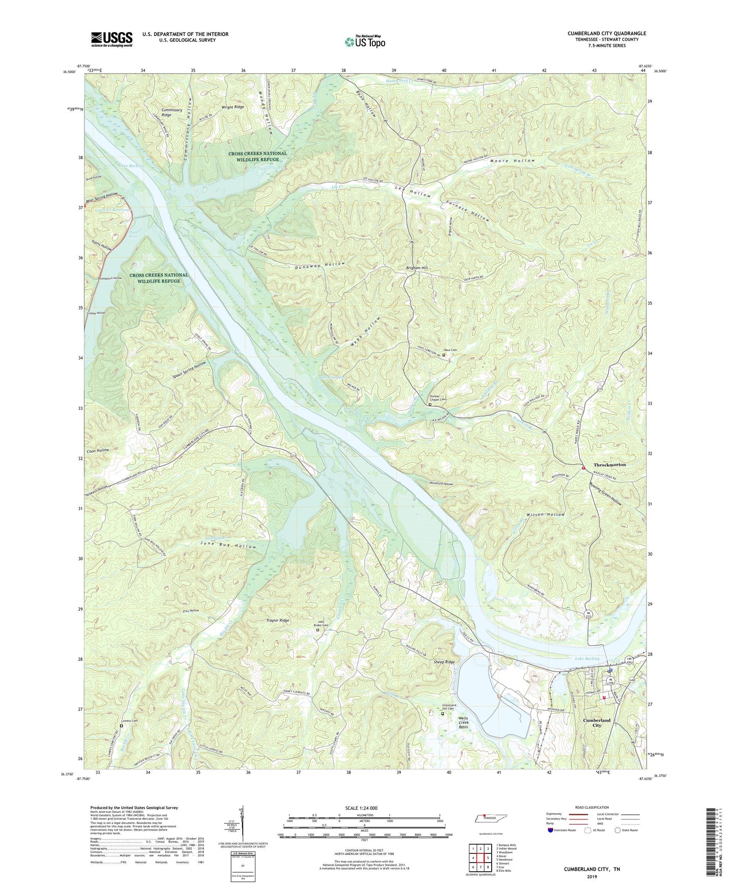
2022 topographic map quadrangle Cumberland City in the state of Tennessee. Scale: 1:24000. Based on the newly updated USGS 7.5' US Topo map series, this map is in the following counties: Stewart. The map contains contour data, water features, and other items you are used to seeing on USGS maps, but also has updated roads and other features. This is the next generation of topographic maps. Printed on high-quality waterproof paper with UV fade-resistant inks.
Quads adjacent to this one:
West: Dover
Northwest: Bumpus Mills
North: Indian Mound
Northeast: Woodlawn
East: Needmore
Southeast: Ellis Mills
South: Erin
Southwest: Stewart
This map covers the same area as the classic USGS quad with code o36087d6.
Contains the following named places: Bald Island, Ballards Chapel, Bear Spring Hollow, Bear Springs Landing, Big Elk Creek, Bone Hollow, Bradfords Landing, Brigham Hill, Brigham Hollow, Bullpasture Creek, Bullpasture Landing, Bussels Mill, Checkered House Landing, Cold Spring Branch, Commissary Hollow, Commissary Ridge, Commissioner District 1, Commissioner District 7, Cross Creek Dam, Cross Creek Ferry, Cross Creek Reservoir, Cross Creeks National Wildlife Refuge, Cumberland City, Cumberland City Ferry, Cumberland City Police Department, Cumberland City Post Office, Cumberland City Quarry, Cumberland City Steam Plant, Cumberland City-Carlisle Division, Cumberland Iron Works, Cumberland Rolling Mill Landing, Dunaway Hollow, Dunbar Branch, Dunbar Chapel, Dunbar Chapel Cemetery, East Fork Little Elk Creek, Elk Creek Church, Ellis Hollow, Furnace Hollow, Graveyard Hill Cemetery, Haus Cemetery, Holliday Branch, Hollister Furnace, Honey Fork Creek, Hopewell Branch, Hopewell Church, Horseford Hollow, John Brake Cemetery, June Bug Hollow, Junebug Branch, Lee Creek, Lee Hollow, Lewis Landing, Lindsey Hollow, Little Dry Elk Creek, Little Elk Creek, Lowery Cemetery, Lowrys Landing, McCartys Landing, Moody Hollow, Moore Hollow, Nash School, North Cross Creek, Paul Chapel, Pauls Chapel School, Pool Five, Pool Five Dam, Pool Fourteen, Pool Fourteen Dam, Pool Six, Pool Six Dam, Potatopatch Hollow, River Bend Recreation Area, Rough and Ready Furnace, Rough and Ready Landing, Scott Branch, Scott Chapel, Scott Chapel School, Sheep Ridge, Skunk Hollow, South Cross Creek, Spout Spring Hollow, Stackers Landing, Stewart County Fire Rescue Station 6, Stewart County Volunteer Fire Department Station 5 Hopewell, Stout Springs School, Taylors Chapel School, Thomas School, Throckmorton, Throckmorton School, Town of Cumberland City, Travis Hollow, Traylor Ridge, Varner School, Varners Landing, Webb Hollow, Wells Creek, Wells Creek Basin, Wells Island, Wilson Branch, Wilson Hollow, Wilson Landing, Wright Ridge, ZIP Code: 37079