MyTopo
Daisy Tennessee US Topo Map
Couldn't load pickup availability
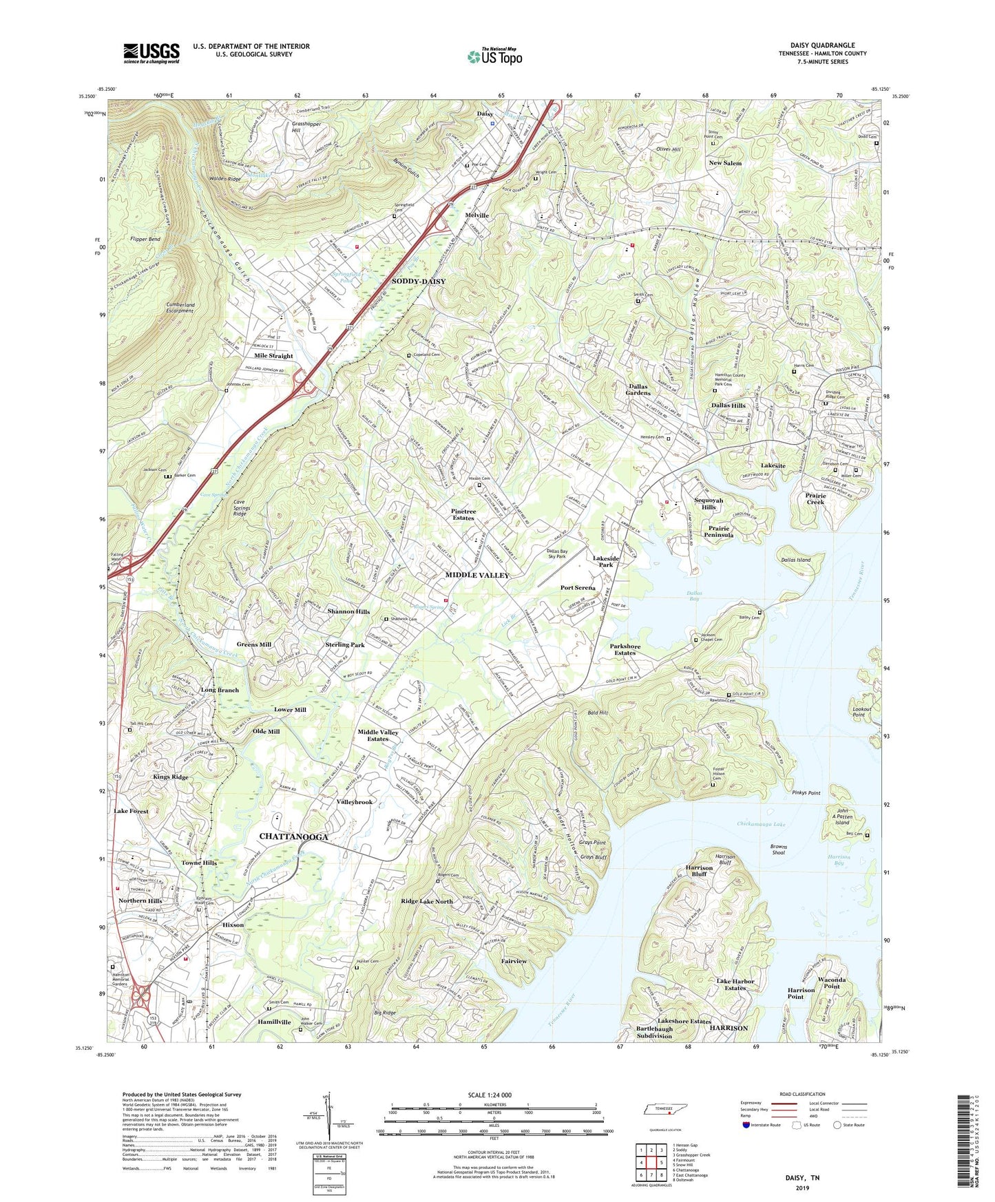
2019 topographic map quadrangle Daisy in the state of Tennessee. Scale: 1:24000. Based on the newly updated USGS 7.5' US Topo map series, this map is in the following counties: Hamilton. The map contains contour data, water features, and other items you are used to seeing on USGS maps, but also has updated roads and other features. This is the next generation of topographic maps. Printed on high-quality waterproof paper with UV fade-resistant inks.
Quads adjacent to this one:
West: Fairmount
Northwest: Henson Gap
North: Soddy
Northeast: Grasshopper Creek
East: Snow Hill
Southeast: Ooltewah
South: East Chattanooga
Southwest: Chattanooga
Contains the following named places: American National Club, Ardis Mobile Home Park, Bailey Cemetery, Bailey Island, Bald Hill, Barker Cemetery, Bartlebaugh Subdivision, Bell Cemetery, Bethel Bible School, Big Ridge, Big Ridge Elementary School, Blue Ridge View, Briarfield, Browns Shoal, Burks Chapel, Bynum Gulch, Camp Columbus, Camp Dixie, Camp Hixson, Camp Tsatanugi, Caramel Village, Cave Springs, Cave Springs Ridge, Central Baptist Church of Hixson, Chattanooga Fire Department Station 19, Chattanooga Rod and Gun Club, Chattanooga Yacht Club, Chickamauga Gulch, City of Lakesite, Clear Branch, Clearwater Acres, Colonial Shores, Commissioner District 3, Copeland Cemetery, Country Oaks Estates, Crabtree Hills, Creeks Bend Golf Club, Crestfield, Cross Timbers, Daisy, Daisy Congregational Church, Daisy Elementary School, Dallas, Dallas Bay, Dallas Bay Sky Park, Dallas Bay Volunteer Fire and Rescue Station 2, Dallas Bay Volunteer Fire Department and Rescue Station 1, Dallas Branch, Dallas Church, Dallas Elementary School, Dallas Gardens, Dallas Hills, Dallas Hollow, Dallas Hollow Shopping Center, Dallas Island, Dallas Plaza Shopping Center, Dana Hills, Davidson Cemetery, Dent Acres, Dividing Ridge Cemetery, Dividing Ridge Church, Dodd Cemetery, Echo Glen, Ephraim Hixon Cemetery, Fairview, Fairview Church, Fairview Harbor, Fairview School, Falling Water Cemetery, Falling Water Church, Falling Water Creek, Fanetta Gardens, Farrington Forest, Flipper Bend, Forest Meade, Forestwood, Foster Hixson Cemetery, Foxwood Estates, Friendship Church, Ganns-Middle Valley Elementary School, Garden Farms, Gold Point Estates, Gold Point School, Grace Church of the Nazarene, Grasshopper Hill, Grays Bluff, Grays Point, Green Cove, Green Hills, Green Pond Church, Greens Mill, Hamilton County, Hamilton County Memorial Park Cemetery, Hamilton County Park, Hamilton Memorial Gardens, Hampton Woods, Harris Cemetery, Harrison Bay, Harrison Bluff, Harrison Branch, Harrison Census Designated Place, Harrison Prospect, Hensley Cemetery, Hickory Woods, Hidden Harbor, Hidden Hills Estates, Hillcrest Estates, Hixson, Hixson Cemetery, Hixson Church, Hixson Church of Christ, Hixson Elementary School, Hixson High School, Hixson Junior High School, Hixson Marina, Hixson Mine, Hixson Post Office, Hixson School, Hixson United Methodist Church, Hogskin Branch, Hunter Cemetery, Huntingdon Forest, Irongate, Ivanwood Acres, Jackson Cemetery, Jackson Chapel, Jackson Chapel Cemetery, Jeffery Acres, John A Patten Island, John H Allen School, John Walker Cemetery, Johnson Cemetery, Kings Ridge, Lake Dweller, Lake Harbor Estates, Lake Shores Country Club, Lakeside Park, Lakesite, Lakesite Marina, Lick Branch, Long Branch, Lookout Point, Lower Mill, Melville, Melville Church, Middle Valley, Middle Valley Baptist Church, Middle Valley Census Designated Place, Middle Valley Church, Middle Valley Church of Christ, Middle Valley Division, Middle Valley Estates, Middle Valley Recreation Area, Mikel Branch, Mile Straight, Mile Straight Baptist Church, Miller Cemetery, Mimosa Trailer Park, Montlake, Mystic Caverns, New Salem, New Salem Baptist Church, Ninemile Branch, North Hixson Church of Christ, North Hixson Church of God, Northern Hills, Northgate Crossing Shopping Center, Northgate Mall, Northmont Estates, Northshore Hills, Olde Mill, Oliver Hill, Ooltera Creek, Parkshore Estates, Pine Hollow, Pinetree Estates, Pinkys Point, Pitts Branch, Pleasant Grove Baptist Church, Poe Branch, Poe Cemetery, Port Serena, Prairie Creek, Prairie Peninsula, Providence Club, Rawlston Cemetery, Reliable Transportation of Tennessee, Richland Crest, Ridge Bay, Ridge Lake North, Riverchase, Roberts Mill Branch, Rogers Branch, Rogers Cemetery, Rogers Chapel, Rogers Spring, Sandalwood Village, Savage Mine, Sequoyah Branch Johnson Mental Health Center, Sequoyah Church, Sequoyah Hills, Sequoyah Vocational Technical School, Sequoyah Volunteer Fire Department Station 2, Serena Chapel, Shadwick Cemetery, Shannon Hills, Sharp Mine, Shelton Estates, Smith Cemetery, Soddy - Daisy City Hall, Soddy - Daisy Fire Department Station 3, Soddy - Daisy Police Department, Soddy-Daisy, Soddy-Daisy Division, Springcrest, Springfield Cemetery, Springfield Pond, Sterling Park, Stoneridge, Stony Point Cemetery, Stony Point Church, Tall Hill Cemetery, Tall Pines Mobile Home Park, Tennessee Department of Agriculture Division of Forestry District 3, Timberwick, Town Hills, Towne Hills, Valleybrook, Valleybrook Golf and Country Club, Waconda Point, WCHU-AM (Soddy-Daisy), WCHU-FM (Soddy-Daisy), Winder Hollow, Wright Cemetery, ZIP Code: 37343