MyTopo
Soddy Tennessee US Topo Map
Couldn't load pickup availability
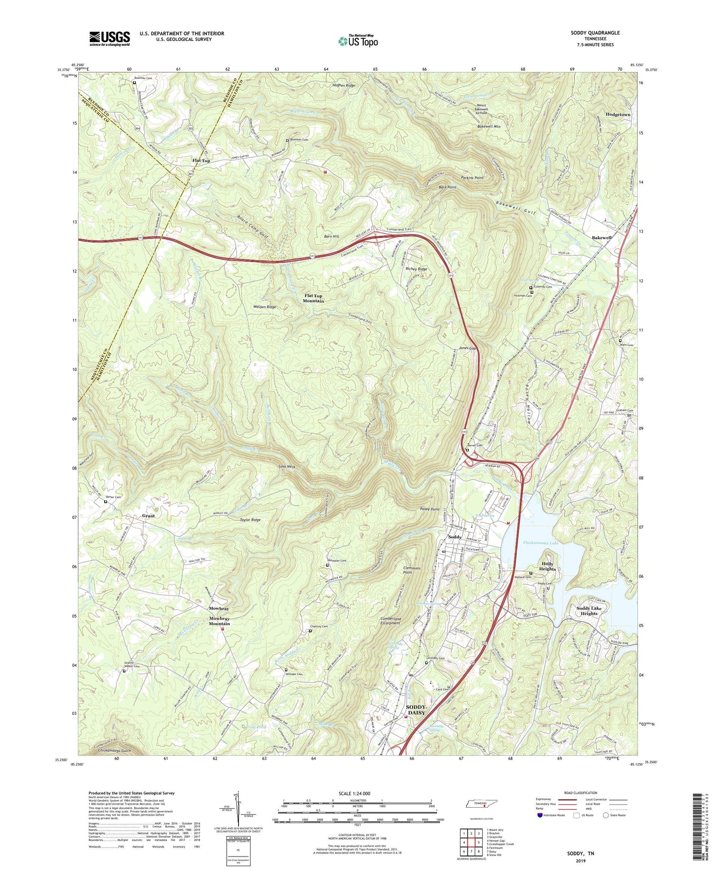
2022 topographic map quadrangle Soddy in the state of Tennessee. Scale: 1:24000. Based on the newly updated USGS 7.5' US Topo map series, this map is in the following counties: Hamilton, Sequatchie, Bledsoe. The map contains contour data, water features, and other items you are used to seeing on USGS maps, but also has updated roads and other features. This is the next generation of topographic maps. Printed on high-quality waterproof paper with UV fade-resistant inks.
Quads adjacent to this one:
West: Henson Gap
Northwest: Mount Airy
North: Brayton
Northeast: Graysville
East: Grasshopper Creek
Southeast: Snow Hill
South: Daisy
Southwest: Fairmount
This map covers the same area as the classic USGS quad with code o35085c2.
Contains the following named places: Bakewell, Bakewell Gulf, Bakewell Mountain, Bakewell School, Bare Point, Barn Hill, Big Possum Creek, Big Soddy Number Seven Mine, Big Soddy Number Three Mine, Board Camp Creek, Board Camp Gulf, Bowman Cemetery, Buckhort Branch, Burchard Mine, Card Cemetery, Carr Branch, Cedar Branch, Chancey Cemetery, City of Soddy-Daisy, Clemmons Point, Cliffs Mill, Coleman Cemetery, Commissioner District 1, Crow Pond, Daisy Mine, Deep Creek, East Soddy Church, First Baptist Church of Daisy, Flat Top, Flat Top Church, Flat Top Mountain Census Designated Place, Flat Top School, Flat Top Volunteer Fire Department, Foster Branch, Graham Cemetery, Granny Walker Cemetery, Grant, Gray Creek, Green Gables Mobile Home Park, Harrison Trailer Park, Hatfield and Luttrell Mine, Hickman Cemetery, Hickory Grove Church, Hineman Spring, Hodgetown, Holly Heights, Horn Branch, Hotwater Cemetery, Huckleberry, Hughes Ridge, Iris Lovelady Spring, J And B Mobile Home Park, Jones Gap, Little Possum Creek, Little Soddy Creek, Long Springs, Lovelady Cemetery, Lovelady Spring, Loyd Spring, Luther Milligan Mine, Mansfield Gulf, McGill Spring, Millsaps Cemetery, Millsaps Church, Montlake Lookout Tower, Montlake Public Shooting Center, Mount Bakewell Airfield, Mountain Shade Mobile Home Park, Mountain View Baptist Church, Mowbray, Mowbray Church, Mowbray Creek, Mowbray Elementary School, Mowbray Mountain Census Designated Place, Mowbray Volunteer Fire Department, North Soddy, Northend Ball Park, Oak Street Baptist Church, Perkins Point, Pilgrim Rest Church, Pine Grove Church, Pine Harbor Dock, Pine Harbor Heights, Posey Hollow, Posey Point, Rathburn Station, Richey Ridge, Sims Neck, Skiles Branch, Soddy, Soddy - Daisy Fire Department Station 1, Soddy Cemetery, Soddy Church of Christ, Soddy Church of God, Soddy Daisy Fire Department Station 2, Soddy Daisy Post Office, Soddy Elementary School, Soddy Lake Heights, Soddy Marine Park, Soddy Municipal Park, Soddy Number One Mine, Soddy Post Office, Soddy-Daisy Junior High School, Taylor Ridge, Triple H Equestrian Farm, Union Fork Church, Varner Cemetery, Walker Branch, Wallace Cemetery, Ware Cemetery, WEDG-AM (Soddy-Daisy), Wolf Creek, ZIP Code: 37379