MyTopo
Dorton Tennessee US Topo Map
Couldn't load pickup availability
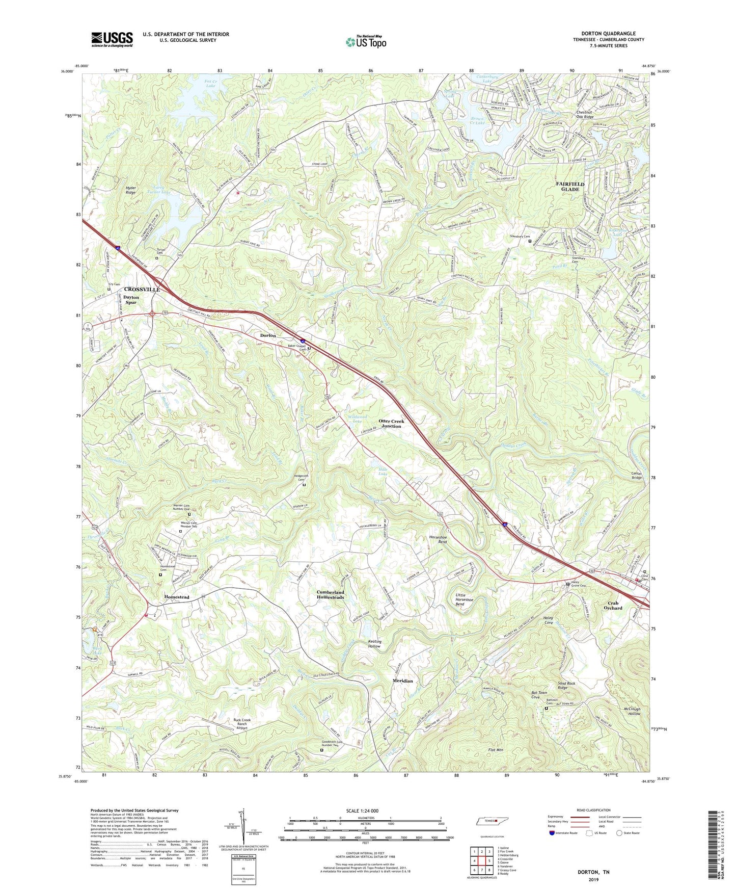
2019 topographic map quadrangle Dorton in the state of Tennessee. Scale: 1:24000. Based on the newly updated USGS 7.5' US Topo map series, this map is in the following counties: Cumberland. The map contains contour data, water features, and other items you are used to seeing on USGS maps, but also has updated roads and other features. This is the next generation of topographic maps. Printed on high-quality waterproof paper with UV fade-resistant inks.
Quads adjacent to this one:
West: Crossville
Northwest: Isoline
North: Fox Creek
Northeast: Hebbertsburg
East: Ozone
Southeast: Roddy
South: Grassy Cove
Southwest: Vandever
Contains the following named places: Bagwell Branch, Baker Branch, Baker Chapel Cemetery, Baker Chapel Methodist Church, Bakers Chapel School, Barnes Branch, Bat Town Cove, Battown Cemetery, Big Branch, Bowling, Brown Creek, Brown Creek Lake, Buck Creek, Buck Creek Ranch Airport, Byrd Creek, Byrd Lake Dam, Canterbury Lake, Canterbury Lake Dam, Center Bridge, Cherry Branch, Chestnut Hill, Chestnut Hill Baptist Church, Chestnut Hill School, Chestnut Oak Ridge, City of Crab Orchard, Clear Branch, Cline Cemetery, Coon Hollow Branch, Cox Branch, Crab Orchard, Crab Orchard Church of Christ, Crab Orchard Church of God, Crab Orchard Post Office, Crab Orchard Quarry, Cry Cemetery, Cumberland County, Cumberland County Fire Department Station 3, Cumberland County Fire Department Station 4 - 1, Cumberland County Fire Department Station 6, Cumberland Homestead Church, Cumberland Homesteads, Daddys Creek, Davis Mine, Dayton Spur, Dorton, Dorton School, Fairview, Flat Mountain, Fox Creek Lake, Goodstock Cemetery Number Two, Hale Lake, Haley Cove, Haley Grove Cemetery, Haley Grove church, Haleys Grove, Haleys Grove School, Hedgecoth, Hedgecoth Cemetery, Hidden Hollow Estates, Highland Estates, Highland Homesite Addition, Highland View, Homestead, Homestead Cemetery, Homestead Church, Homestead Elementary School, Homestead High School, Homestead School, Horseshoe Bend, Hyder Ridge, Keating Hollow, Kemmers Old Stand, Kirkstone Lake, Kirkstone Lake Dam, Lake Sherwood, Larry Turner Lake, Larry Turner Lake Dam, Lead Branch, Little Horseshoe Bend, Long Branch, McClough Hollow, McGinnis Ford, Meadow Creek, Meadow Creek Church, Meadows Creek Church, Meridian, Meridian School, Mountain View Estates, Muddy Branch, North Creek, Onemile Creek, Otter Creek Junction, Pine Grove Estates, Pinethicket Branch, Polebridge Branch, Rowells Orchards, Saint George Lake, Saint George Lake Dam, Sand Rock Ridge, Sanderson Branch, Sherwood Dam, Spring Branch, Spring Lake, Spring Lake Dam, Stansbury Cemetery, Threemile Creek, Turner Brothers Quarry, Turner Cemetery, Ward Branch, Warner Cemetery Number One, Warner Cemetery Number Two, Wildwood Lake, Willis Branch, ZIP Code: 38555