MyTopo
Ozone Tennessee US Topo Map
Couldn't load pickup availability
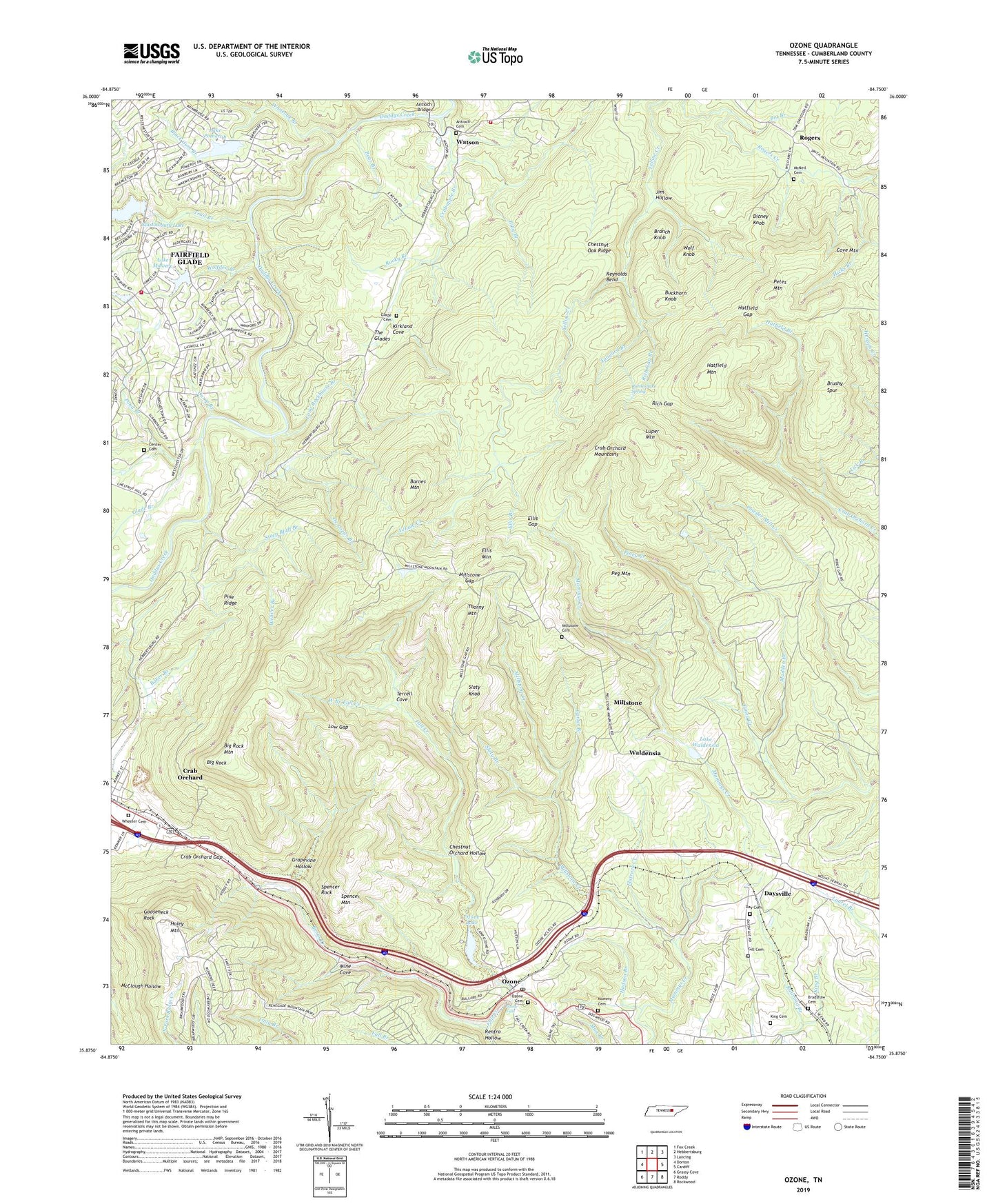
2022 topographic map quadrangle Ozone in the state of Tennessee. Scale: 1:24000. Based on the newly updated USGS 7.5' US Topo map series, this map is in the following counties: Cumberland. The map contains contour data, water features, and other items you are used to seeing on USGS maps, but also has updated roads and other features. This is the next generation of topographic maps. Printed on high-quality waterproof paper with UV fade-resistant inks.
Quads adjacent to this one:
West: Dorton
Northwest: Fox Creek
North: Hebbertsburg
Northeast: Lancing
East: Cardiff
Southeast: Rockwood
South: Roddy
Southwest: Grassy Cove
This map covers the same area as the classic USGS quad with code o35084h7.
Contains the following named places: Antioch Bridge, Antioch Cemetery, Antioch Church, Antioch School, Barnes Ford, Barnes Mountain, Bear Branch, Berks Creek, Big Branch, Big Rock, Big Rock Mountain, Billy Branch, Black Gum Branch, Bradshaw Cemetery, Branch Knob, Brushy Spur, Buckhorn Knob, Camp Branch, Camp Ozone Dam, Carter Branch, Catoosa Wildlife Management Area, Center Cemetery, Center Ford, Center School, Chestnut Oak Ridge, Chestnut Orchard Hollow, Commissioner District 6, Cove Mountain, Crab Orchard Division, Crab Orchard Elementary School, Crab Orchard Gap, Crab Orchard Mountains, Crabapple Branch, Cumberland County Fire Department Station 6 - 2, Cumberland County Highway Department Quarry, Day Cemetery, Daysville, Daysville Baptist Church, Daysville School, De Lozier Branch, Ditney Knob, Dochester, Ellis Branch, Ellis Gap, Ellis Mountain, Fairfield Glade Fire Department Station 3, Fall Branch, Flatrock Creek, Frank Center Ford, Franklin Mine, Gill Cemetery, Glade Branch, Glade Cemetery, Glastowbury Lake, Glastowbury Lake Dam, Gooseneck Rock, Grapevine Hollow, Haley Mountain, Hatfield Branch, Hatfield Ford, Hatfield Gap, Hatfield Mountain, Hicks Branch, Hudson Branch, Jim Hollow, King Cemetery, Kirkland Cove, Lake Malvern, Lake Pomeroy, Lake Pomeroy Dam, Lake Waldensia, Lake Waldensia Dam, Long Rockhouse Branch, Low Gap, Luper Mountain, Madden Branch, Malvern Dam, Mammy Cemetery, McNeil Cemetery, Millstone, Millstone Branch, Millstone Cemetery, Millstone Church of Christ, Millstone Creek, Millstone Gap, Millstone School, Mine Cove, Ozone, Ozone Cemetery, Ozone Falls, Ozone Lake, Ozone Post Office, Peg Mountain, Petes Mountain, Pine Grove School, Pine Ridge, Pond Branch, Railroad Branch, Rattlesnake Spring, Renegade, Renfro Hollow, Reynolds Bend, Rich Gap, Rich Gap Branch, Rocky Branch, Rogers, Rogers Church of Christ, Sandy Stand, Slaty Branch, Slaty Knob, Spencer Mountain, Spencer Rock, Steep Bluff Branch, Tanyard Branch, Terrell Cove, The Glades, Thorny Mountain, Trail Branch, Waldensia, Watson, WCPT-TV (Crossville), Weaver Branch, West Branch Fall Creek, Wheeler Cemetery, Whiteoak Branch, Windsor Bluff, Wolf Knob, Wolfden Branch, ZIP Code: 37723