MyTopo
Roddy Tennessee US Topo Map
Couldn't load pickup availability
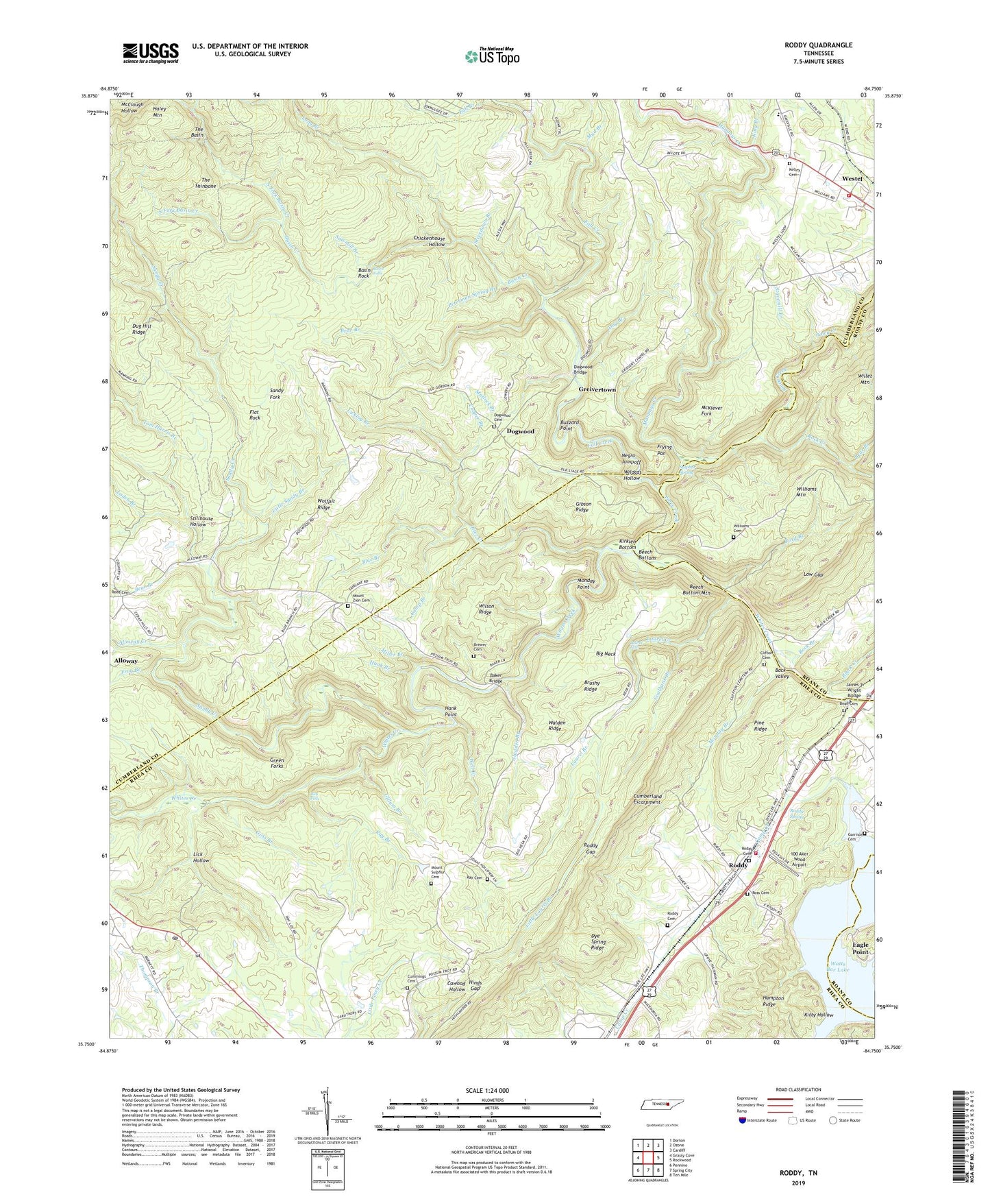
2022 topographic map quadrangle Roddy in the state of Tennessee. Scale: 1:24000. Based on the newly updated USGS 7.5' US Topo map series, this map is in the following counties: Cumberland, Rhea, Roane. The map contains contour data, water features, and other items you are used to seeing on USGS maps, but also has updated roads and other features. This is the next generation of topographic maps. Printed on high-quality waterproof paper with UV fade-resistant inks.
Quads adjacent to this one:
West: Grassy Cove
Northwest: Dorton
North: Ozone
Northeast: Cardiff
East: Rockwood
Southeast: Ten Mile
South: Spring City
Southwest: Pennine
This map covers the same area as the classic USGS quad with code o35084g7.
Contains the following named places: 100 Aker Wood Airport, 37337, Alloway Creek, Back Valley, Baker Bridge, Basin Creek, Basin Falls, Basin Rock, Bean Cemetery, Bear Branch, Beech Bottom, Beech Bottom Mountain, Bethel Baptist Church, Big Neck, Big Sandy School, Black Creek, Blue Branch, Boy Scout Memorial, Brewer Cemetery, Brushy Ridge, Buzzard Point, Camp Branch, Camp Creek, Chickenhouse Hollow, Clifton Cemetery, Coal Creek, Coalbank Branch, Cooper Branch, Cumberland County Fire Department Station 6 - 1, Cummings Cemetery, Day Branch, Dogwood, Dogwood Bridge, Dogwood Cemetery, Dug Hill Ridge, Dye Spring Ridge, Eagle Point, Fall Creek, Fall Creek Church, Flat Rock, Ford Branch, Frog Branch, Frying Pan, Garrison Cemetery, Gibson Inn, Gibson Ridge, Gillum Branch, Gladden Branch, Goss Branch, Grandview Church, Grandview Post Office, Green Forks, Greivers Chapel, Greivertown, Haley Mountain, Hank Branch, Hank Point, Hinds Gap, James T Wright Bridge, Johnson Chapel, Kelley Cemetery, King Branch, Kirklen Bottom, Kitty Hollow, Laurel Branch, Laurel Creek, Laurel Falls, Lick Hollow, Licklog Branch, Little Harris Branch, Little Laurel Branch, Little Sandy Branch, Loden Branch, Long Branch, Low Gap, Macedonia Church, Mammys Creek, Manning School, Matlock Branch, McKiever Fork, Miller Branch, Monday Branch, Monday Point, Mount Sulphur, Mount Sulphur Cemetery, Mount Zion, Mount Zion Baptist Church, Mount Zion Cemetery, Mud Branch, Negro Jumpoff, Newport Resort, North Fork Basin Creek, Otter Creek, Owl Roost Gap, Peterman Spring Branch, Pine Ridge, Pineview School, Piney Creek, Ray Branch, Ray Cemetery, Ray Falls, Reid Camp, Renegade Resort, Rhea County Fire Department Station 2 715 Roddy Fire District, Rock Branch, Rock Creek, Roddy, Roddy Cemetery, Roddy Gap, Roddy High School, Roddy School, Roddy Spring, Ross Cemetery, Sandy Creek, Sandy Fork, Sawmill Branch, South Fork Basin Creek, Stavemill Branch, Steerdown Branch, Stillhouse Hollow, Sulphur Spring, The Basin, The Shinbone, Tom Harris Branch, Walden Ridge Airport, Well Branch, Westel, Whites Creek Small Wildlife Area, Wildcat Hollow, Williams Cemetery, Williams Mountain, Wilson Ridge, Wolfpit Ridge