MyTopo
Douglas Dam Tennessee US Topo Map
Couldn't load pickup availability
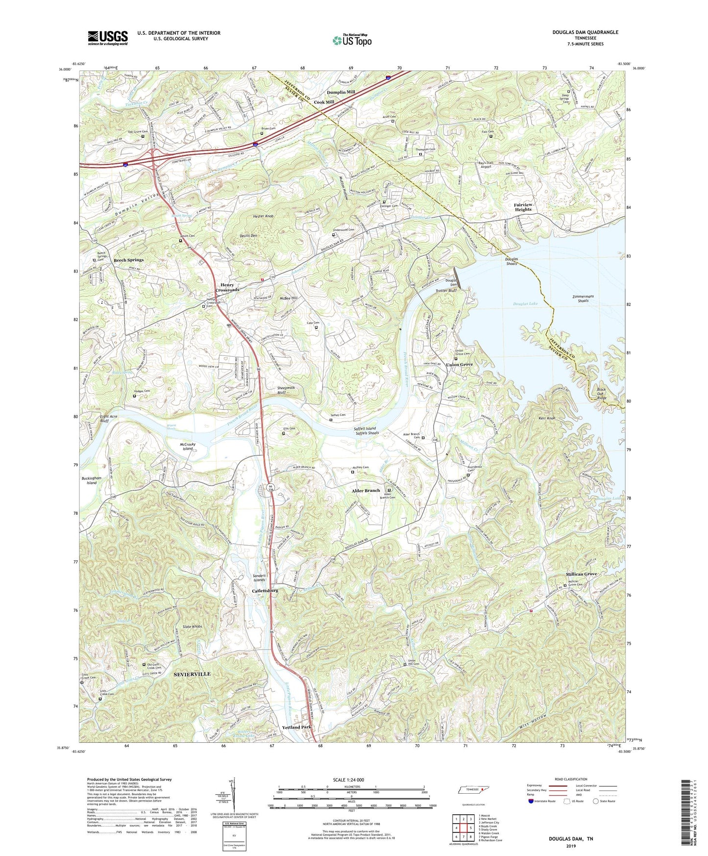
2019 topographic map quadrangle Douglas Dam in the state of Tennessee. Scale: 1:24000. Based on the newly updated USGS 7.5' US Topo map series, this map is in the following counties: Sevier, Jefferson. The map contains contour data, water features, and other items you are used to seeing on USGS maps, but also has updated roads and other features. This is the next generation of topographic maps. Printed on high-quality waterproof paper with UV fade-resistant inks.
Quads adjacent to this one:
West: Boyds Creek
Northwest: Mascot
North: New Market
Northeast: Jefferson City
East: Shady Grove
Southeast: Richardson Cove
South: Pigeon Forge
Southwest: Walden Creek
Contains the following named places: Acuff Cemetery, Alder Branch, Alder Branch Baptist Church, Alder Branch Baptist Church Cemetery, Atchley Isaac Cemetery, Bailey School, Bailey Spring, Beech Springs, Beech Springs Cemetery, Black Oak Ridge, Bryan Cemetery, Bryant Shoals, Cate Cemetery, Cate crossroad, Catlett School, Catlettsburg, City of Sevierville, Commissioner District 7, Commissioner District 8, Cook Mill, Deep Springs, Deep Springs Baptist Church, Deep Springs Cemetery, Deep Springs School, Devils Den, Douglas Creek, Douglas Dam, Douglas Dock, Douglas School, Douglas Shoals, Dumplin Mill, Eight Acre Bluff, Ellis Cemetery, Esslinger Cemetery, Evergreen Pointe Mobile Home Park, Ewing, Fain Cemetery, Fairview Heights, Flat Creek, French Broad, French Broad Academy, French Broad Valley Church, Gann Branch, Gibson Acres Mobile Home Park, Gists Creek, Gists Creek Cemetery, Gists Creek Church, Henry Crossroads, Henrys Crossroads Cemetery, Hester Knob, Hill Cemetery, Hodges Cemetery, Hodges Ferry, Island View Dock, Johnny Creek, Kellum Creek, Kellum School, Kerr Knob, Kodak Post Office, Kodak School, Kykers Ferry, Lafollette Hollow, Leatherwood Branch, Little Gists Creek, Little Millican Creek, Little Pigeon River, Luretta Church, McBee Hill, McCrosky Island, Midway School, Millican Creek, Millican Grove, Millican Grove Baptist Church, Millican Grove Cemetery, Millican School, Mount Cemetery, Mount Spring, Mutton Hollow, Mutton Hollow Creek, Northview Kodak Volunteer Fire Department Station 2, Oak Grove Cemetery, Oak Grove Church, Old Gists Creek Cemetery, Old McMahan Cemetery, Petty Branch, Powder Springs, Providence Cemetery, Providence Church, Ray's Stall Airport, Reed School, Revilo, Saddle Dam 1, Saddle Dam 10, Saddle Dam 3, Saddle Dam 4, Saddle Dam 5, Saddle Dam 6, Saddle Dam 7, Saddle Dam 8, Saddle Dam 9, Saffell Cemetery, Saffell Island, Saffels Shoals, Sanders Islands, Sevier County Park, Sevier County Volunteer Fire Department Station 3, Sheepwalk Bluff, Slate Branch, Slatey Branch, Sportsman Shop Dock, Stokley Ferry, Thompson Cemetery, Trotter Bluff, Underwood Cemetery, Union Grove, Union Grove Cemetery, Union Grove School, Union Hill, Union Hill Cemetery, Waters Estate Dam, Waters Estate Lake, WSEV-AM (Sevierville), Yettland Park, Zimmerman Island, Zimmermans Shoals, ZIP Code: 37764