MyTopo
Jefferson City Tennessee US Topo Map
Couldn't load pickup availability
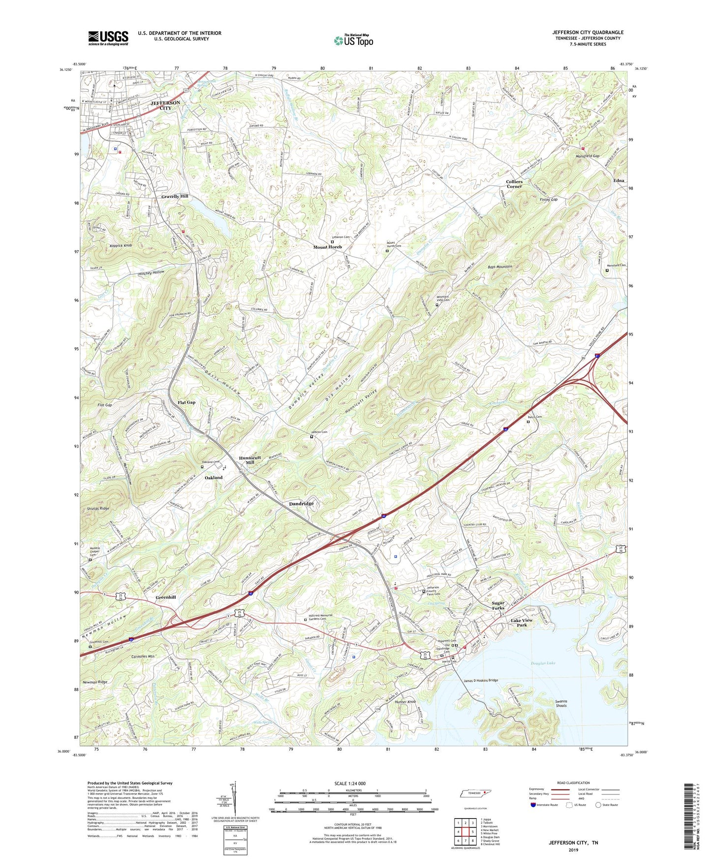
2022 topographic map quadrangle Jefferson City in the state of Tennessee. Scale: 1:24000. Based on the newly updated USGS 7.5' US Topo map series, this map is in the following counties: Jefferson. The map contains contour data, water features, and other items you are used to seeing on USGS maps, but also has updated roads and other features. This is the next generation of topographic maps. Printed on high-quality waterproof paper with UV fade-resistant inks.
Quads adjacent to this one:
West: New Market
Northwest: Joppa
North: Talbott
Northeast: Morristown
East: White Pine
Southeast: Chestnut Hill
South: Shady Grove
Southwest: Douglas Dam
This map covers the same area as the classic USGS quad with code o36083a4.
Contains the following named places: Athletic Mine, Batch Cemetery, Bethel Presbyterian Church, Brown Chapel, Buffalo Grove Church, Buffalo Wallow Branch, Burke-Tarr Stadium, Carmines Mountain, Carson-Newman College, Cedar Ridge School, Chaney Branch, Chestnut Grove, Chestnut Grove United Methodist Church, Christ Temple African Methodist Episcopal Zion Church, City of Jefferson City, City Spring, College Square Shopping Center, Colliers Corner, Commissioner District 1, Commissioner District 5, Commissioner District 9, Cox Store, Coy Zinc Mine, Dandridge, Dandridge City Hall, Dandridge Division, Dandridge Dock, Dandridge Elementary School, Dandridge Golf and Country Club, Dandridge Historic District, Dandridge Municipal Park, Dandridge Police Department, Dandridge Post Office, Dandridge Volunteer Fire Department, Davis Hollow, Davis Mill, Devoll Church, Dry Hollow, Edna, Finley Gap, Fire Control Headquarters Fire Tower New Market, First Baptist Church of Dandridge, First Methodist Church, Five Chimneys Plantation, Flat Gap, Flat Gap Church, Foust Pond, Franklin Mill, Galloway Landing, Grants Chapel, Gravelly Hill, Great Indian War Trail Monument, Greenhill, Greenhill Branch, Greenhill Cemetery, Greenhill Church, Greenhill School, Gum Pond, Harris Cemetery, Hebron Cemetery, Hebron Church, Hillcrest Memorial Gardens Cemetery, Hills Mill, Hinchey Hollow, Holt Fieldhouse, Hopewell Cemetery, Hopewell Presbyterian Church, Hunnicutt Branch, Hunnicutt Mill, Hunnicutt Valley, Hunter Knob, James D Hoskins Bridge, Jefferson City, Jefferson City Community Center, Jefferson City Division, Jefferson City Fire Department, Jefferson City First Baptist Church, Jefferson City Police Department, Jefferson County, Jefferson County Courthouse, Jefferson County EMS, Jefferson County Farm, Jefferson County Farm Cemetery, Jefferson County High School, Jefferson County Industrial Park, Jefferson County Nursing Home, Jefferson County Rescue Squad, Jefferson County Sheriff's Office, Jefferson Shopping Center, Kansas Talbott Volunteer Fire Department, Koontz Creek, Koppick Knob, Lake View Park, Lakeway Central Volunteer Fire Department, Lebanon Cemetery, Lebanon Church, Manley Infirmary, Mansfield Cemetery, Mansfield Gap, Mansfield Gap Church, Maples Library, Maury Middle School, Mossy Creek, Mossy Creek Spring, Mount Horeb, Mount Horeb Cemetery, Mount Horeb Church, Mount Horeb School, Mount Vale Church, Mount Zion Church, Mountain View, Mountain View Cemetery, Mountain View Church, Mutton Hollow, Newman Ridge, Oakland, Oakland Cemetery, Oakland Methodist Church, Old Dandridge Cemetery, Paradise Pointe, Patterson Chapel, Reinhardts Island, Rimmer Creek, Riverview School, Roper Tavern, Schrader School, Shields Ridge, Smith Chapel, Sugar Forks, Swanns Shoals, Thomas Pond, Town of Dandridge, Underwood Store, Wells Spring, Wesley Chapel, Wesleys Chapel Cemetery, WJFC-AM (Jefferson City), ZIP Code: 37760