
MyTopo
Elk Mills Tennessee US Topo Map
Couldn't load pickup availability
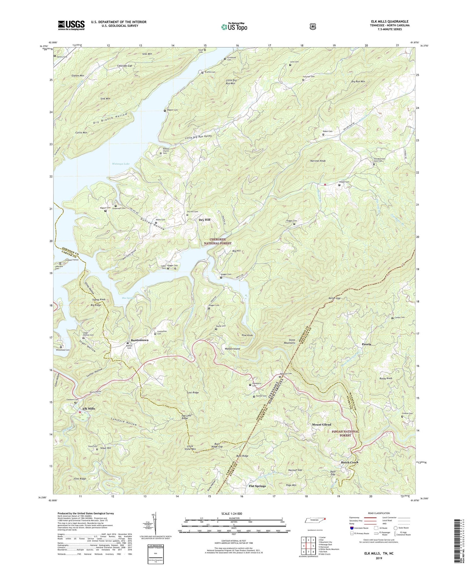
2019 topographic map quadrangle Elk Mills in the states of Tennessee, North Carolina. Scale: 1:24000. Based on the newly updated USGS 7.5' US Topo map series, this map is in the following counties: Johnson, Carter, Watauga, Avery. The map contains contour data, water features, and other items you are used to seeing on USGS maps, but also has updated roads and other features. This is the next generation of topographic maps. Printed on high-quality waterproof paper with UV fade-resistant inks.
Quads adjacent to this one:
West: Watauga Dam
Northwest: Carter
North: Doe
Northeast: Mountain City
East: Sherwood
Southeast: Valle Crucis
South: Elk Park
Southwest: White Rocks Mountain
Contains the following named places: Asher Branch, Baker Branch, Baker Cemetery, Baker Gap Church, Beech Creek, Beech Valley Church, Big Dry Run, Big Hill, Big Ridge, Blue Springs, Bradley Cemetery, Bradley School, Buck Ridge, Buck Ridge Gap, Buck Ridge Lookout Tower, Bunton Cemetery, Bunton Creek, Buntontown, Cable Cemetery, Cable Prospect, Campbell Hollow, Casper, Colorado Gap, Combs Cemetery, Commissioner District 4, Cowanstown, Crosswhite Cemetery, Curtis Mountain, Dave Gap, Doubles Branch, Draught Creek, Dry Branch Hollow, Dry Hill, Dry Hill Cemetery, Dry Run Elementary School, Dry Run Mine, Dry Run Mountain, Dry Run Volunteer Fire Department, Dugger Bridge, Dugger Cemetery, Dugger Prospect, Duncan Hollow, Dye Leaf Branch, Dye Leaf Ridge, Eastman, Elk Church, Elk Mills, Elk Mills - Poga Volunteer Fire Department, Elk Mills Baptist Church, Elk Mills Christian Church, Elk Mills School, Elk River, Farthing, Farthing Cemetery, Flat Springs, Flat Springs Branch, Fletcher Cemetery, Freeman and Young Mine, Frog Pond School, Gentry Cemetery, Goodwin Cemetery, Goss Mine, Green Hollow, Green Valley Baptist Church, Greene Cemetery, Greenwell Cemetery, Gregg Boat Dock, Gregg Branch, Gregg School, Grindstaff Cemetery, Harmon Gap, Heaton Branch, Holloway Prospect, Ironville, Keller Gap, Lakeview Cemetery, Laws Cemetery, Lipford Branch, Little Dry Run, Little Dry Run Mountain, Little Dry Run Valley, Little Laurel Branch, Little Stone Mountain, Lost Ridge, Lower Elk River School, Lunsford Hollow, Lupperts Flume Bridge, Luther Hollow, Meadow View Church, Meadows School, Meal Camp Hollow, Midway Church, Moody Prospect, Morgan Branch, Mount Gilead, Mount Gilead Church, Mountain View Church, Narrows Knob, Neva Division, Norris, Old Mountain View Cemetery, Payne Cemetery, Peoria, Pine Bottom Branch, Pine Knob, Poga Creek, Proffitt Cemetery, Roan Creek, Roan Creek Boat Dock, Rocky Knob, Sheets Hollow, Sink Mountain, Sink Mountain Recreation Area, Sink Valley Church, Sink Valley School, Slimp Hollow, Snyder Cemetery, Snyders School, Stansberry Cemetery, Stanton Prospect, Stone Mountain Branch, Stone Mountain Church, Stout Cemetery, Stout Hill, Stout Hill Church, Stump Knob, Sugar Grove Church, Sugar Hollow, Sugar Hollow Branch, Sugar Hollow Cemetery, Timbered Ridge Baptist Church, Tom Baker Branch, Wagner Cemetery, Wagner Island, Wagner Prospect, Watauga Academy, Watauga River Mine, Watson Island, Whitehead Cemetery, Wolfe Cemetery, ZIP Code: 37640


