MyTopo
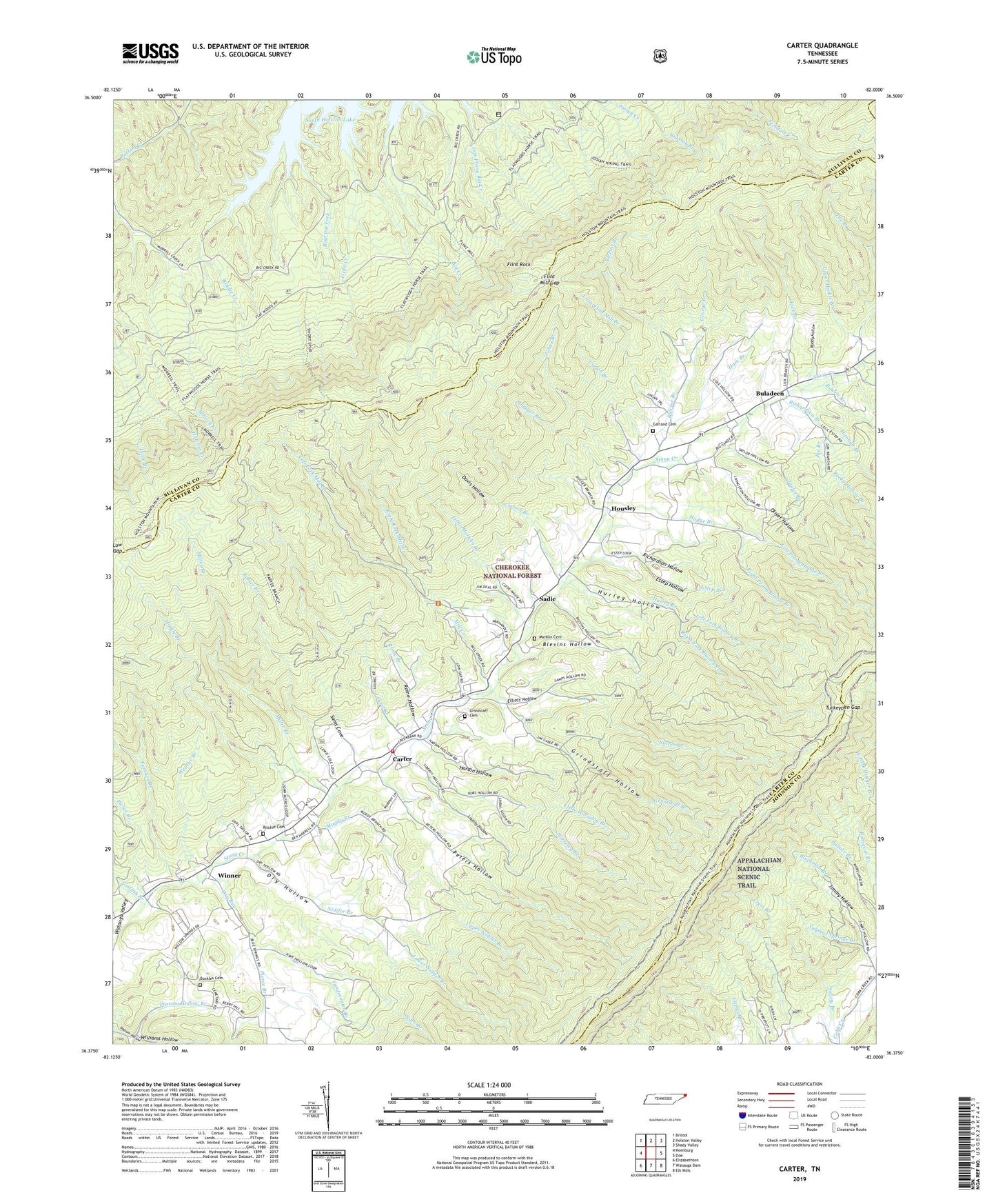
Carter Tennessee US Topo Map
Couldn't load pickup availability
Also explore the Carter Forest Service Topo of this same quad for updated USFS data
2022 topographic map quadrangle Carter in the state of Tennessee. Scale: 1:24000. Based on the newly updated USGS 7.5' US Topo map series, this map is in the following counties: Carter, Sullivan, Johnson. The map contains contour data, water features, and other items you are used to seeing on USGS maps, but also has updated roads and other features. This is the next generation of topographic maps. Printed on high-quality waterproof paper with UV fade-resistant inks.
Quads adjacent to this one:
West: Keenburg
Northwest: Bristol
North: Holston Valley
Northeast: Shady Valley
East: Doe
Southeast: Elk Mills
South: Watauga Dam
Southwest: Elizabethton
This map covers the same area as the classic USGS quad with code o36082d1.
Contains the following named places: Bartee Branch, Bear Wallow Mine, Blackman Branch, Blevins Branch, Blevins Hollow, Blevins Mine, Bowen Branch, Boyd Spring Pond, Buckles Cemetery, Buladeen, Buladeen School, Caldwell Springs Church, Carter, Carter Branch, Clarion Branch, Commissioner District 1, Davis Hollow, Dry Hollow, Dry Run, Dugger Branch, Elliott Hollow, Estep Branch, Estep Hollow, Flint Mill Gap, Flint Mill Trail, Flint Rock, Fork Ridge, Furnace Branch, Gap Field Ridge, Garland Cemetery, George Branch, Griffith Branch, Griffith Mine, Grindstaff Branch, Grindstaff Cemetery, Grindstaff Hollow, Grindstaff Prospect, Grindstaff Ridge, Ham Branch, Hannah Branch, Hardin Hollow, Hatcher Prospect, Hatcher Pyrite Mine, Helenmode Pyrite Mine, Hickory Flat Branch, Hinkle Branch, Hodge Branch, Hodge Mine, Holly Springs Branch, Holly Springs Church, Holston High Knob, Holston Mountain, Holston Mountain Trail, Horselog Branch, Horselog Ridge, Housley, Huckleberry Ridge, Hurley Branch, Hurley Hollow, Ike Branch, Jess Heatherly Prospect, Jimmy Hollow, Johns Branch, Josiah Trail, Lane Hill School, Laurel Branch, Left Fork Hurley Branch, Left Fork Mill Creek, Left Prong Hodge Branch, Liberty Hollow, Lick Branch, Lipps Ridge, Lipps Ridge Mine, Little Flint Mill Branch, Little Horselog Branch, Little Marklin Branch, Low Gap, Low Gap Campground, Low Hill Ridge, Lower Nidifer Branch, Marklin Cemetery, Middle Ridge Mine, Midway School, Mill Creek, Miller Branch, Morrell Creek, Morrill Trail, Muddy Branch, Muddy Hollow, Nave Branch, Nidifer Branch, Nidifer Prospect, North Fork Stony Creek, Oliver Hollow, Peters Branch, Peters Hollow, Peters Ridge, Pierce Branch, Poe Branch, Red Eye Ridge, Richardson Branch, Richardson Hollow, Right Fork Hurley Branch, Right Fork Mill Creek, Right Prong Hodge Branch, Ritchie Cemetery, Ritts Ridge, Ritts Ridge Prospect, Roaring Fork, Rocky Hollow Branch, Rome Branch, Rome Hollow, Roundabout Ridge, Sadie, Sams Cove, Short Spur Trail, Speedwell Bloomary Forge, Stoney Creek Baptist Church, Stoney Creek Volunteer Fire Department Station 1, Stony Creek Division, Stony Creek Fire Tower, Stoutson Quarry, Stover Branch, Sulphur Springs Branch, Taylor Branch, Taylor Ore Bank Mine, Taylor Prospect, Taylor Ridge, Taylor Ridge Mine, Turkeypen Gap, Unaka Baptist Church, Unaka Elementary School, Upper Carter Bloomary Forge, Upper Hinkle Branch, Upper Nidifer Branch, Vandeventer Branch, Weaver Branch, WETS-FM (Johnson City), Williams Hollow, Winner, Winner School