MyTopo
Flintville Tennessee US Topo Map
Couldn't load pickup availability
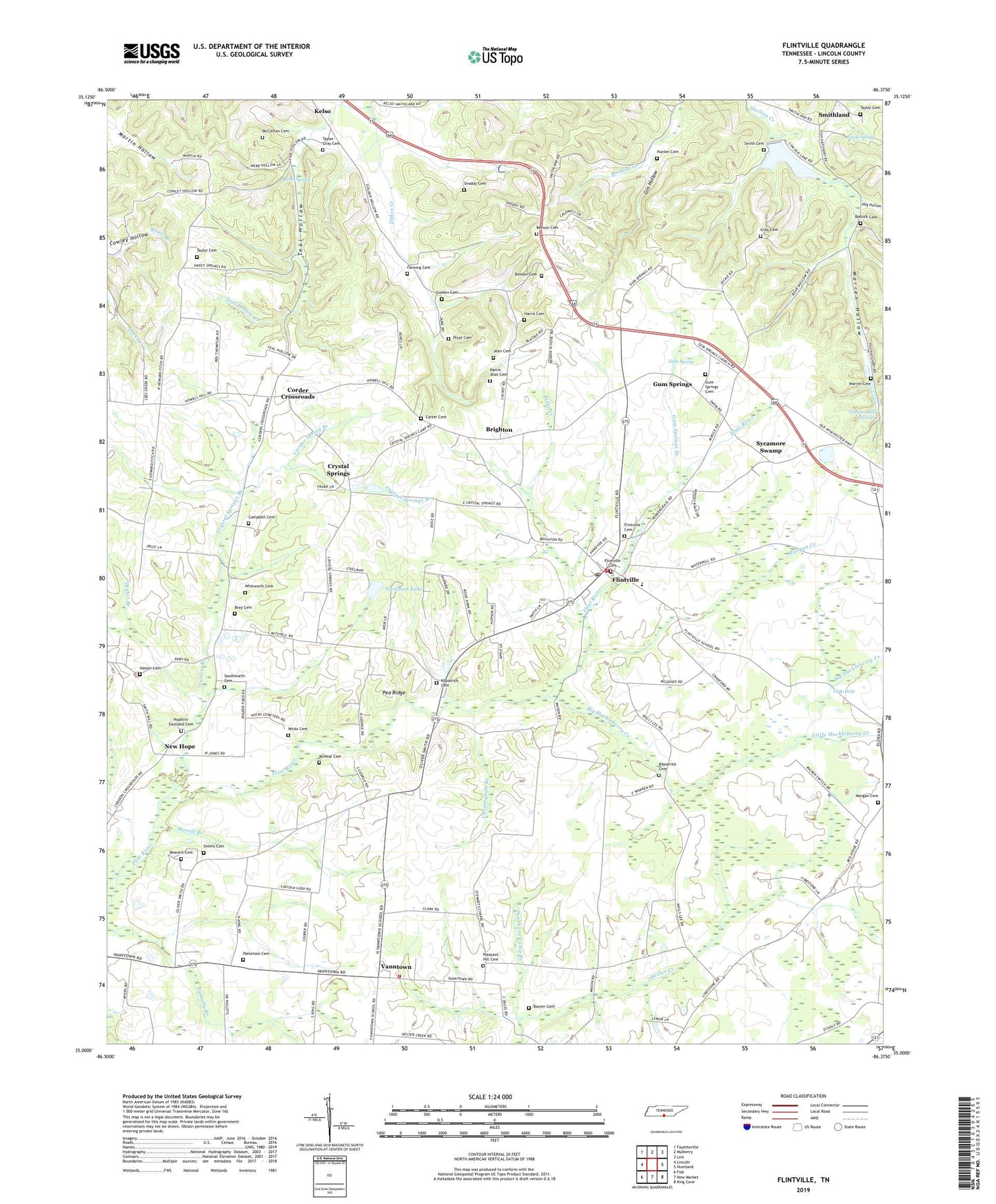
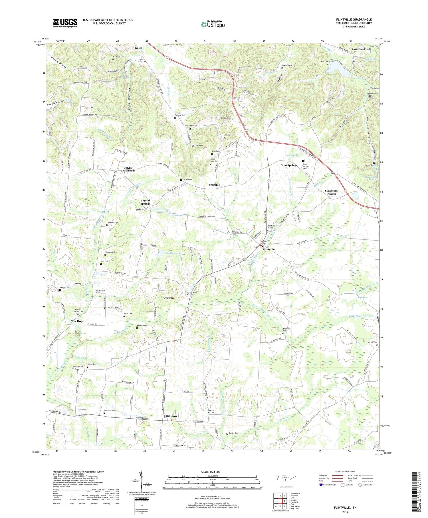
2019 topographic map quadrangle Flintville in the state of Tennessee. Scale: 1:24000. Based on the newly updated USGS 7.5' US Topo map series, this map is in the following counties: Lincoln. The map contains contour data, water features, and other items you are used to seeing on USGS maps, but also has updated roads and other features. This is the next generation of topographic maps. Printed on high-quality waterproof paper with UV fade-resistant inks.
Quads adjacent to this one:
West: Lincoln
Northwest: Fayetteville
North: Mulberry
Northeast: Lois
East: Huntland
Southeast: King Cove
South: New Market
Southwest: Fisk
Contains the following named places: Baxter Cemetery, Beavers Cemetery, Benson Cemetery, Benson School, Big Huckleberry Creek, Bostick Cemetery, Brannon Cotton Farm, Bray Cemetery, Brighton, Campbell Cemetery, Carter Cemetery, Commissioner District 7, Corder Crossroads, Corder Spring Branch, Corders Crossroads School, Crystal Springs, Crystal Springs Branch, Cunningham Branch, Drach Farm, Fanning Cemetery, Fayetteville Pumping Station, Flintville, Flintville Cemetery, Flintville Census Designated Place, Flintville Division, Flintville Elementary School, Flintville First Baptist Church, Flintville Junior High School, Flintville Post Office, Flintville Volunteer Fire Rescue, Gin Hollow, Golden Cemetery, Gray Cemetery, Gum Spring, Gum Springs, Gum Springs Branch, Gum Springs Cemetery, Gum Springs Church, Harbin Branch, Harris Cemetery, Harris-Jean Cemetery, Hester Branch, Hester Cemetery, Hog Hollow, Hopkins-Eastland Cemetery, Hunter Cemetery, Jean Cemetery, Kelso Spring, Kilpatrick Cemetery, Lincoln Lake, Lincoln Lake Dam, Little Huckleberry Creek, Lucy Memorial Church, Maddox Farm, Marty Farms, McClellan Cemetery, McCracken School, McNeal Cemetery, Merrill Branch, Milners Switch, Morgan Cemetery, Mulepen Creek, New Hope, New Hope Baptist Church, Nixon Spring, Patterson Cemetery, Pleasant Grove Church, Pleasant Hill Cemetery, Pleasant Hill Church, Pryor Cemetery, Puncheon Camp Branch, Raby Brothers Farm, Simms Cemetery, Smith Cemetery, Smithland, Snoddy Cemetery, Southworth Cemetery, Steelman Lake, Steelman Lake Dam, Stewart Chapel, Stiles Creek, Sycamore Swamp, Taylor Cemetery, Taylor-Gray Cemetery, Teal Hollow, Teal Hollow Creek, Tilda Hole, Trotters Branch, Vann School, Vanntown, Vanntown Volunteer Fire and Rescue, Vinsons Mill Springs, Warren Cemetery, Warren Hollow, Whitworth Cemetery, Wicks Cemetery, ZIP Code: 37335