MyTopo
Lois Tennessee US Topo Map
Couldn't load pickup availability
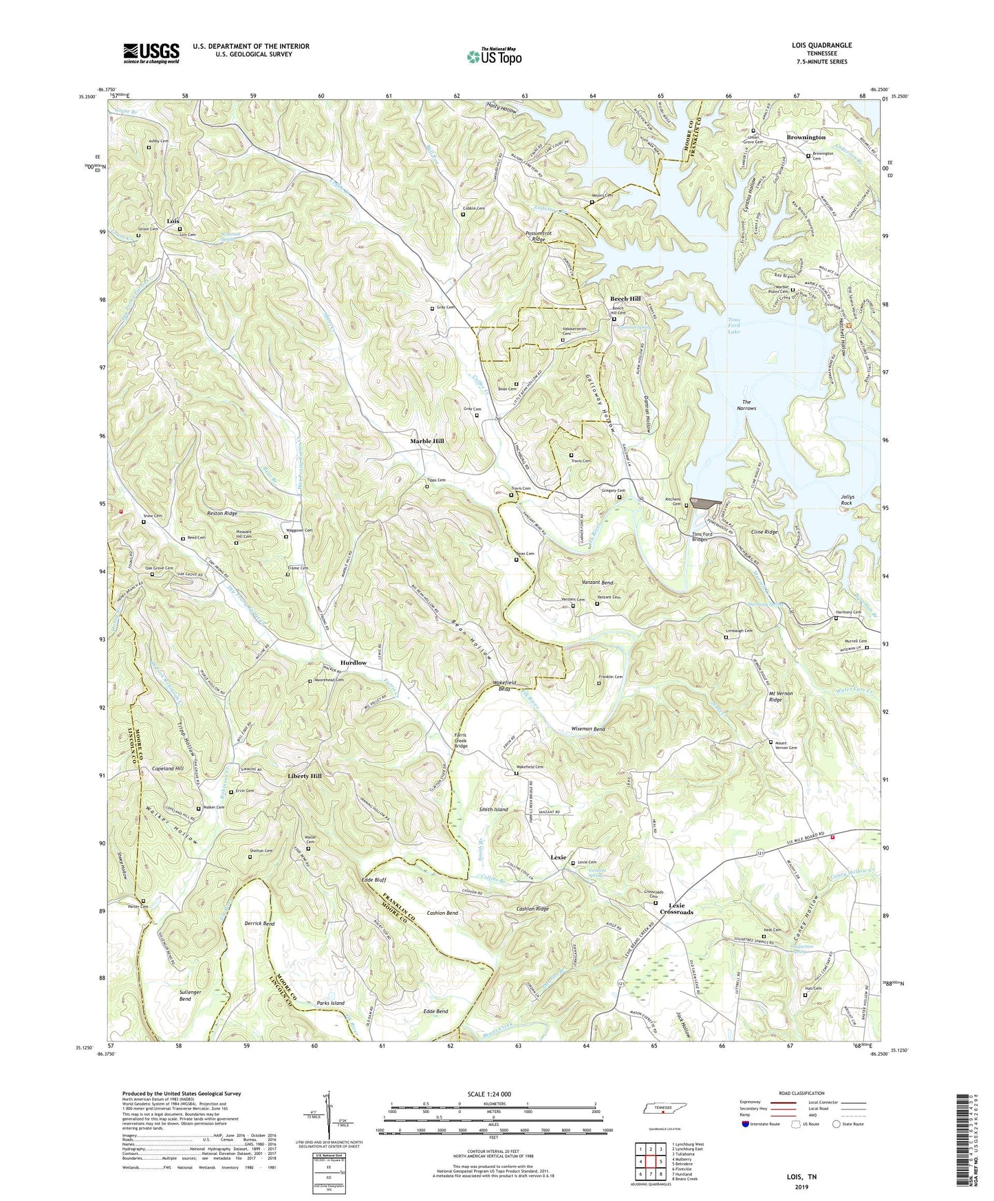
2022 topographic map quadrangle Lois in the state of Tennessee. Scale: 1:24000. Based on the newly updated USGS 7.5' US Topo map series, this map is in the following counties: Moore, Franklin, Lincoln. The map contains contour data, water features, and other items you are used to seeing on USGS maps, but also has updated roads and other features. This is the next generation of topographic maps. Printed on high-quality waterproof paper with UV fade-resistant inks.
Quads adjacent to this one:
West: Mulberry
Northwest: Lynchburg West
North: Lynchburg East
Northeast: Tullahoma
East: Belvidere
Southeast: Beans Creek
South: Huntland
Southwest: Flintville
This map covers the same area as the classic USGS quad with code o35086b3.
Contains the following named places: Anderton Branch, Anderton Branch Public Use Area, Arbor Church, Ashby Cemetery, Bean Cemetery, Bean Hollow, Beans Creek, Bear Branch, Beech Hill, Beech Hill Cemetery, Beech Hill Church, Beech Hill School, Blue Hole, Brandon Chapel, Browington Cemetery, Browington Church of the Nazarene, Brownington, Bull Run, Cashion Bend, Cashion Ridge, Cline Ridge, Cline Ridge Cabin Sites, Cobble Cemetery, Coffee Creek, Collins Branch, Commissioner District 3, Cooper Branch, Copeland Hill, Crossroads Cemetery, Cynthia Hollow, Damron Hollow, Damron Spring, Davis School, Derrick Bend, Dry Prong Farris Creek, Ebenezer Church, Edde Bend, Edde Bluff, Ervin Cemetery, Farris Creek, Farris Creek Bridge, Frame Cemetery, Franklin Cemetery, Fuga School, Galloway Hollow, Garner Ford, Gray Cemetery, Gregory Cemetery, Gum Springs Church, Hall Cemetery, Harmony Cemetery, Harmony Cumberland Presbyterian Church, Harmony School, Harmony Spring, Hasty Hollow, Hatchett Hollow, Hawkersmith Cemetery, Hurdlow, Hurdlow School, Jollys Rock, Kings Hole, Kitchens Cemetery, Lexie, Lexie Cemetery, Lexie Church of Christ, Lexie Cross Roads Baptist Church, Lexie Cross Roads School, Lexie Crossroads, Lexie Crossroads Volunteer Fire Department, Liberty Hill, Liberty Hill School, Limbaugh Cemetery, Lois, Lois Cemetery, Lois School, Lost Creek, Majors Cemetery, Maple Grove School, Marble Hill, Marble Hill United Methodist Church, Marble Plains, Marble Plains Cemetery, Marble Plains Church, Metro Lynchburg Moore County Volunteer Fire Department Station 2 Fuga, Moorehead Cemetery, Mount Vernon Cemetery, Mount Vernon Church, Mount Vernon Ridge, Mount Vernon School, Murrell Cemetery, Murrell Creek, Narrows Cabin Sites, Neal Cemetery, Neal Creek, Oak Grove Cemetery, Oak Grove Church, Parks Island, Parks Mill, Pleasant Hill Cemetery, Porter Cemetery, Porter School, Possumtrot Ridge, Quarles Branch, Ray Branch, Reed Cemetery, Reston Ridge, Robinson Creek, Sheep Hollow, Shelton Cemetery, Short Creek, Smith Branch, Smith Chapel, Smith Island, Snow Cemetery, Stiles Ford, Sugartree Spring, Sullenger Bend, Sylvanus School, Templeton Branch, The Narrows, Tims Ford Bridges, Tims Ford Dam, Tipps Cemetery, Travis Cemetery, Tripp Hollow, Turn Hole, Union Cemetery, Union Church, Union Grove Cemetery, Union Grove Church, Vanzant Bend, Vanzant Cemetery, Vanzant Spring, Waggoner Cemetery, Wagoner Hollow, Wakefield Bend, Wakefield Cemetery, Walker Cemetery, Walker Hollow, Waller Cemetery, Water Cure Creek, West Fork Robinson Creek, Wet Prong Farris Creek, Wiseman Bend, Wiseman Branch, Wiseman Spring