MyTopo
Halls Creek Tennessee US Topo Map
Couldn't load pickup availability
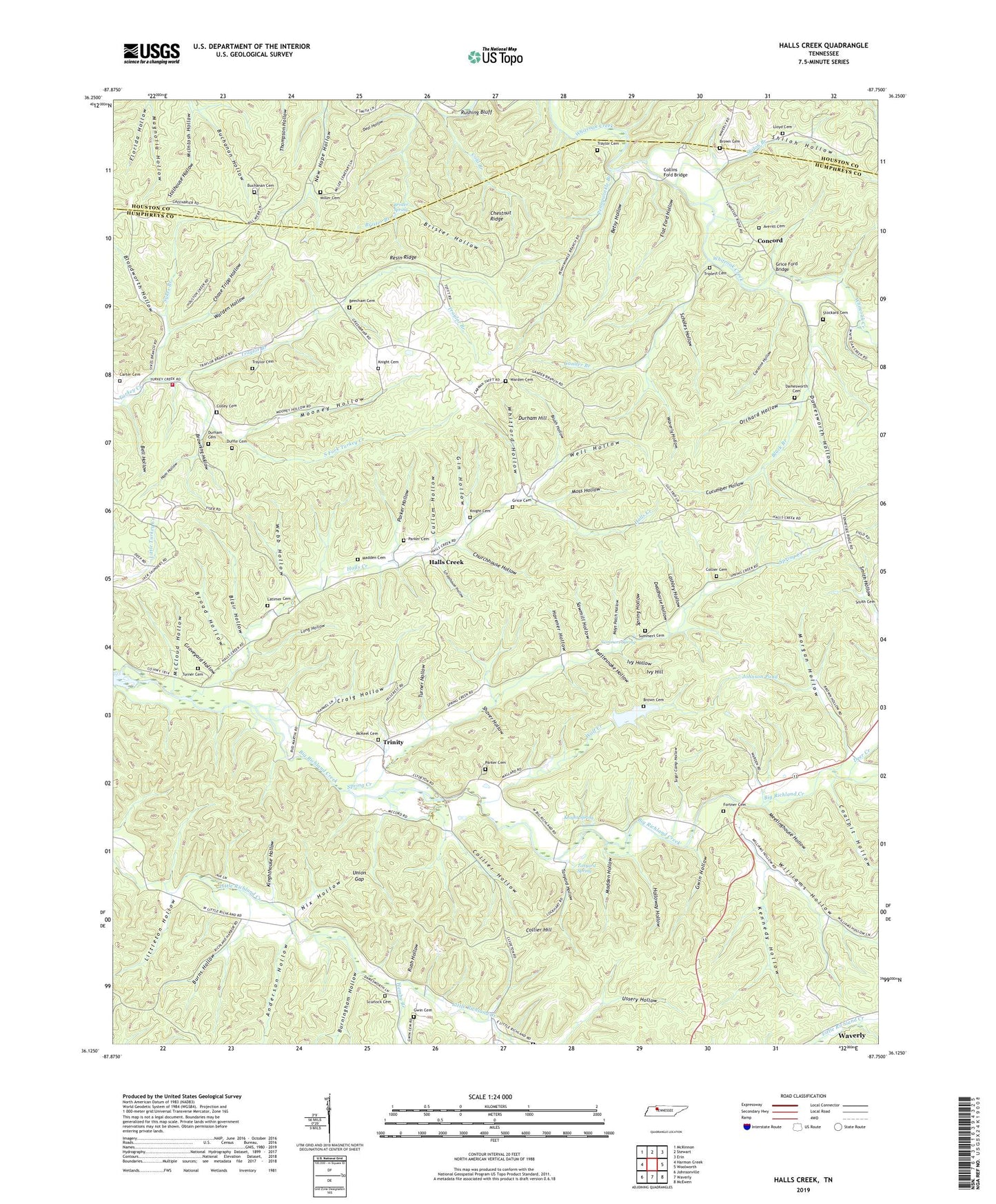
2019 topographic map quadrangle Halls Creek in the state of Tennessee. Scale: 1:24000. Based on the newly updated USGS 7.5' US Topo map series, this map is in the following counties: Humphreys, Houston. The map contains contour data, water features, and other items you are used to seeing on USGS maps, but also has updated roads and other features. This is the next generation of topographic maps. Printed on high-quality waterproof paper with UV fade-resistant inks.
Quads adjacent to this one:
West: Harmon Creek
Northwest: McKinnon
North: Stewart
Northeast: Erin
East: Woolworth
Southeast: McEwen
South: Waverly
Southwest: Johnsonville
Contains the following named places: Anderson Hollow, Averitt Cemetery, Bascom Church, Beecham Cemetery, Bell Hollow, Belleview, Belleview Church, Belleview School, Betsy Hollow, Black Branch, Blair Hollow, Bloodworth Hollow, Brister Hollow, Brister Spring, Broad Hollow, Brown Cemetery, Browning Hollow, Brush Hollow, Buchanan Cemetery, Buchanan Hollow, Burningham Hollow, Burns Hollow, Caroline Hollow, Carter Cemetery, Chase Tripp Hollow, Chestnut Ridge, Churchhouse Hollow, Coalpit Hollow, Cold Branch, Colley Cemetery, Collier Cemetery, Collier Hill, Collier Hollow, Collins Ford, Collins Ford Bridge, Commissioner District 1, Concord, Craig Hollow, Cucumber Hollow, Cullum Hollow, Damesworth Cemetery, Damesworth Hollow, Deadhorse Hollow, Deal Hollow, Deer Creek, Duffle Cemetery, Durham Cemetery, Durham Hill, Elizabeth School, Ellis Grove Church, Ellis Grove School, Flat Ford Hollow, Florida Hollow, Fortner Cemetery, Gander Branch, Gin Hollow, Graveyard Hollow, Grice Cemetery, Grice Ford Bridge, Gwin Cemetery, Gwin Hollow, Halls Creek, Halls Creek Church, Halls Creek School, Ham Hollow, Havener Hollow, Hemby Branch, Holloway Hollow, Humphreys County Fire Department District 5, Ivy Hill, Ivy Hollow, Johnson Pond, Kennedy Hollow, Kinghthouse Hollow, Knight Cemetery, Knight Spring, Lashley Hollow, Latimer Cemetery, Littleton Hollow, Lloyd Cemetery, Long Hollow, Madden Cemetery, Madden Hollow, Mays Patch Hollow, McCloud Hollow, McKeel Cemetery, Meetinghouse Hollow, Miller Cemetery, Mooney Hollow, Morgan Hollow, Moriah Church, Moss Hollow, Nix Hollow, Orchard Hollow, Parker Cemetery, Parker Hollow, Pennywinkle Branch, Pleasan Hill Church, Rattlesnake Hollow, Resin Ridge, Rush Hollow, Rushing Bluff, Sawmill Hollow, Scholes Hollow, Schoolhouse Hollow, Scurlock Cemetery, Shaver Hollow, Shiloh Branch, Shiloh Hollow, South Fork Turkey Creek, Spring Creek, Spring Hollow, Stillhouse Hollow, Stockard Cemetery, Sugar Camp Hollow, Sullivans Mill, Summers Cemetery, Summers Spring, Sykes Branch, Tanyard Hollow, Tanyard Spring, Traylor Branch, Traylor Cemetery, Trinity, Triplett Cemetery, Turner Cemetery, Turner Hollow, Union Gap, Warden Cemetery, Warden Hollow, Waverly Hollow, Webb Hollow, Well Hollow, Whitford Hollow, Williams Hollow, Wolf Creek, WSM Airport