MyTopo
McKinnon Tennessee US Topo Map
Couldn't load pickup availability
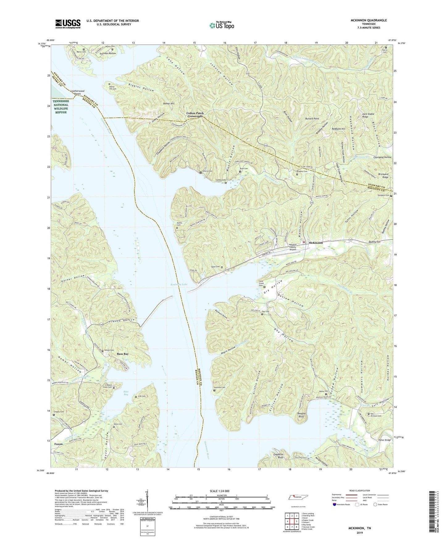
2022 topographic map quadrangle McKinnon in the state of Tennessee. Scale: 1:24000. Based on the newly updated USGS 7.5' US Topo map series, this map is in the following counties: Houston, Benton, Stewart, Henry. The map contains contour data, water features, and other items you are used to seeing on USGS maps, but also has updated roads and other features. This is the next generation of topographic maps. Printed on high-quality waterproof paper with UV fade-resistant inks.
Quads adjacent to this one:
West: Poplar Creek
Northwest: Paris Landing
North: Standing Rock
Northeast: Dover
East: Stewart
Southeast: Halls Creek
South: Harmon Creek
Southwest: Big Sandy
This map covers the same area as the classic USGS quad with code o36087c8.
Contains the following named places: Andrews Cemetery, Askew Cemetery, Askew Hollow, Askew Landing, Bass Bay, Bass Bay Resort, Bass Bay Resort Dock, Benton County Park, Bethlehem Church, Bethlehem School, Big Sandy Dock Number Two, Biggins Hollow, Black Hollow, Blackwell Hollow, Blue Pond, Boat Yard Landing, Bomar Hill, Bomar Hill Cemetery, Bradley Cemetery, Bradley Hollow, Brickyard Ridge, Bridge Hollow, Brier Hollow, Bullard Point, Bullard Point Crossroads, Bush Cemetery, Bush Hollow, Cane Creek, Cane Creek Cemetery, Cane Creek Dock, Caney Branch, Cathey Cemetery, Chadwick Hollow, Chadwick Landing, Cherry Cemetery, Cinder Ford, Copperas Bluff, Cotton Patch Crossroads, Crooked Creek, Crooked Creek Cemetery, Crooked Creek Church, Crooked Creek School, Curt Branch, Curt Hollow, Cypress Pond, Danville, Danville Ferry, Danville Landing, Danville River Terminal, Daugherly Landing, Day Cemetery, Day Hollow, Days Chapel, Douglas Bluff, Douglas Ford, Dry Hollow, Dry Hollow Branch, Dudley Cut, Dudley Hollow, East Onward Landing, Eclipse Furnace, Ellison Hollow, Fairfield School, Faxon School, French Hollow, Furnace Stack Hollow, Garner Hollow, Gin Pond, Grafried Cemetery, Grafried Landing, Griffin, Griffin Church, Griffin Hollow, Griffin School, Harris Branch, Harris Cemetery, Hawk Landing, Hayswood Hollow, Hazel Hollow, Hill Orchard Cemetery, Holmes Hollow, Homer Hollow, Houston County Airport, Houston County Fire Department Tennessee Ridge Station, Hurricane Creek, Hurricane Islands, Irish Cemetery, Jack Stable Ridge, Jones Hollow, Keel Ford, LaGrange Furnace, Lane Hollow, Lead Creek Hollow, Leatherwood Creek, Leatherwood Resort, Leatherwood School, Leatherwood Shoals, Lick Creek, Lindsey Cemetery, Little Crooked Creek, Lott Hollow, Lower Hurricane School, Lower Lagrange Landing, Maple Pond, Martin Cemetery, Mathis Cemetery, Mathis Hollow, McKinnon, McKinnon School, Moore Hollow, Morgan Hollow, Negro Hollow, Newport Landing, North Fork Crooked Creek, Outlaw Hollow, Pafford Landing, Parker Bridge, Randys Camp, Randys Camp Dock, Redbank Hill, Redbank Hill Crossroads, Richland Creek, Rocky Pond, Sandys Camp, Sandys Camp Dock, Sebbles Mill, Shaddock Hollow, South Fork Cane Creek, South Fork Crooked Creek, Southernaire Dock, Southernaire Resort, Spurgeon Cemetery, Stagner Landing, Stribling, Sullivan Hollow, Summers Hollow, Swamp Bank Mines, Sykes Cemetery, Sykes Hollow, Upper Lagrange Landing, West Onward Landing, White Hollow, Whiteoak Boat Dock, Whiteoak Creek, Whiteoak Island, Whites Camp Dock, Whites Resort, Wilkerson Hollow, Wilson Cemetery, Wynn Cemetery, Wynns Cemetery, Youngs Landing, ZIP Code: 37175