MyTopo
Lascassas Tennessee US Topo Map
Couldn't load pickup availability
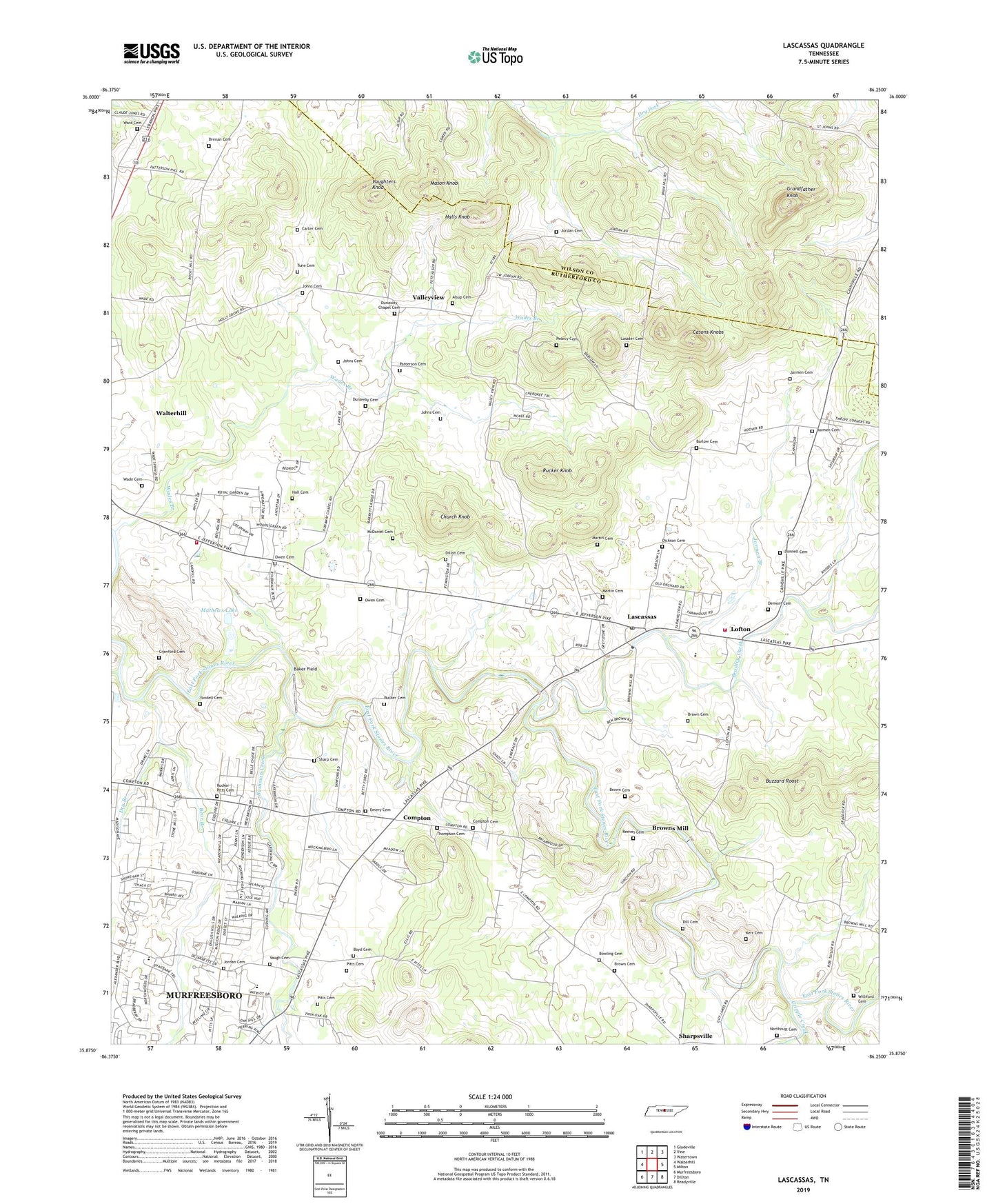
2019 topographic map quadrangle Lascassas in the state of Tennessee. Scale: 1:24000. Based on the newly updated USGS 7.5' US Topo map series, this map is in the following counties: Rutherford, Wilson. The map contains contour data, water features, and other items you are used to seeing on USGS maps, but also has updated roads and other features. This is the next generation of topographic maps. Printed on high-quality waterproof paper with UV fade-resistant inks.
Quads adjacent to this one:
West: Walterhill
Northwest: Gladeville
North: Vine
Northeast: Watertown
East: Milton
Southeast: Readyville
South: Dillton
Southwest: Murfreesboro
Contains the following named places: Alsup Cemetery, Baker Field, Barlow Cemetery, Bear Branch, Bethel, Bethel School, Bethlehem Church, Bowling Cemetery, Boyd Cemetery, Bradley Creek, Brian Manor, Briarwood, Brown Cemetery, Browns Mill, Browns Mill Dam, Browns Mill Lake, Bushman Creek, Buzzard Roost, Canebrake, Carter Cemetery, Casons Knobs, Church Knob, Commissioner District 2, Compton, Compton Cemetery, Compton Meadows, Crawford Cemetery, Cripple Creek, Delay Estates, Dement Cemetery, Dickson Cemetery, Dill Cemetery, Dillon Cemetery, Donnell Cemetery, Drenan Cemetery, Dry Branch, Dunaway Cemetery, Dunaway Chapel, Dunaway Chapel Cemetery, Emery Cemetery, Emery Estates, Emery School, Emery United Methodist Church, Esquire Estates, Estes Acres, Fairfield Estates, Farmington Estates, Fieldcrest, Grandfather Knob, Hall Cemetery, Halls Knob, Holly Grove Church, Jarman Branch, Jarmen Cemetery, Jerrerson Farms, Johns Cemetery, Jordan Cemetery, Jordan School, Kerr Cemetery, Lasater Cemetery, Lascassas, Lascassas Baptist Church, Lascassas Census Designated Place, Lascassas Colonial Acres, Lascassas Division, Lascassas High School, Lascassas Post Office, Lascassas Volunteer Fire Department Headquarters, Little Bethel Church, Lofton, Martin Cemetery, Mason Knob, Mathews Lake, Mathews Lake Dam, McDaniel Cemetery, Murfreesboro Quarry, Murfreesboro Water Treatment Plant, New Las Casas, Nolan School, Northcutt Cemetery, Oak Hill, Oakland Estates, Oakland High School, Owen Cemetery, Patterson Cemetery, Pearcy Cemetery, Pitts Cemetery, Reeves Cemetery, Republican Grove Church, Riverwood, Rucker Cemetery, Rucker Knob, Rucker-Pitts Cemetery, Rutherford County Landfill, Saint Johns, Saint Johns Church, Saint Johns School, Sharp Cemetery, Sharpsville Church, Silver Hill School, Thompson Cemetery, Tune Cemetery, Two Hills, Valleyview, Van Moors Mill, Vaugh Cemetery, Vaughters Knob, Wade Cemetery, Wades Branch, Walnut Grove Church, Walter Hill Church, Walter Hill Dam, Walter Hill Lake, Walter Hill Volunteer Fire Department Station 1 Headquarters, Walterhill Census Designated Place, Ward Cemetery, Williford Cemetery, Yandell Cemetery, ZIP Codes: 37085, 37130