MyTopo
Mascot Tennessee US Topo Map
Couldn't load pickup availability
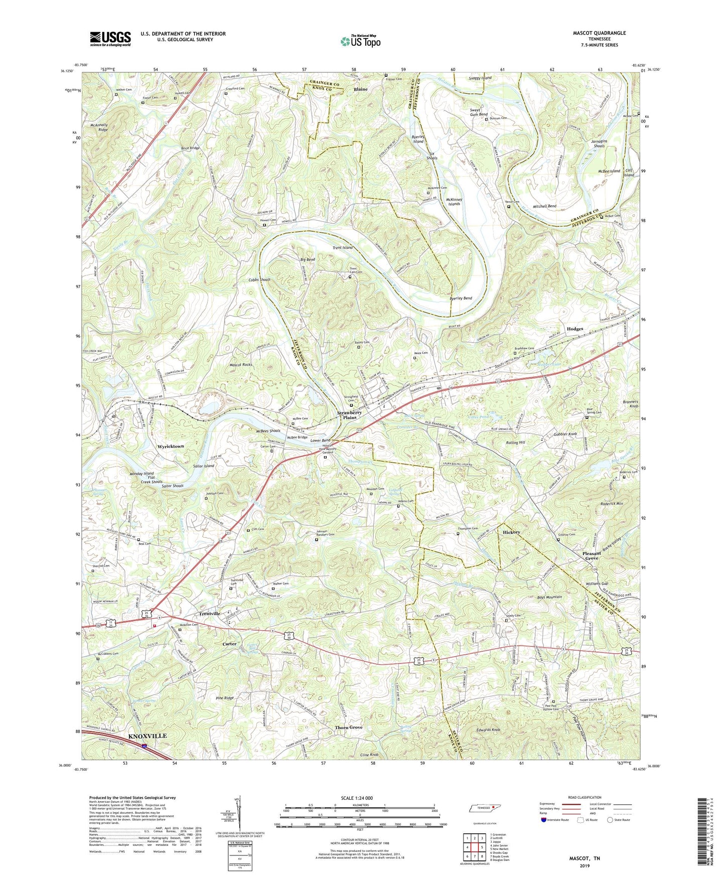
2019 topographic map quadrangle Mascot in the state of Tennessee. Scale: 1:24000. Based on the newly updated USGS 7.5' US Topo map series, this map is in the following counties: Knox, Jefferson, Sevier, Grainger. The map contains contour data, water features, and other items you are used to seeing on USGS maps, but also has updated roads and other features. This is the next generation of topographic maps. Printed on high-quality waterproof paper with UV fade-resistant inks.
Quads adjacent to this one:
West: John Sevier
Northwest: Graveston
North: Luttrell
Northeast: Joppa
East: New Market
Southeast: Douglas Dam
South: Boyds Creek
Southwest: Shooks Gap
Contains the following named places: Adams Cemetery, Bailey Cemetery, Baker Spring, Barley Bend School, Bays Mountain, Beal Cemetery, Beaver Creek, Beaver Creek Church, Big Bend, Blue Spring Cemetery, Blue Spring Church, Boiling Springs, Bradshaw Cemetery, Branners Knob, Brice Branch, Brice Bridge, Byerley Bend, Byerley Chapel, Byerley Island, Caldwell Spring, Calf Island, Carter, Carter Cemetery, Carter Community Park, Carter Elementary School, Carter High School, Carter Middle School, Carter Mill, Carter Mill Springs, Cates Pond, Clear Springs Church, Clear Springs School, Clift Cemetery, Clift Creek, Cline Knob, Cobbs Shoals, Commissioner District 6, Crawford Cemetery, Cress Pond, Crowder Branch, Cynthiana School, Duggan Branch, Duncum Cemetery, Edwards Knob, Flat Creek, Flat Creek Shoals, Foster Cemetery, Frazier Cemetery, Gillette Cemetery, Gobbler Knob, Green Acres Church, Hickory, Hodges, Hodges Lake, Holston Church, Holston View Memory Gardens, House Mountain Substation, Howell Cemetery, Immel Zinc Mine, Jarnagins Shoals, Johnson Cemetery, Johnson-Randlers Cemetery, Lower Bend, Lyon Creek, Lyon Creek Church, Lyonton, Mascot, Mascot Mine, Mascot Park, Mascot Post Office, Mascot Rocks, Mascot School, McBee Bridge, McBee Cemetery, McBee Ferry, McBee Ford, McBee Island, McBees Shoals, McCubbins Cemetery, McKinney Cemetery, McKinney Islands, McMillan Cemetery, Meek Cemetery, Mill Pond, Mitchell Bend, Monday Island, Moulden Cemetery, Nicely Branch, Paw Paw Hollow, Paw Paw Hollow Cemetery, Paw Paw Hollow Church, Pine Ridge, Piney School, Pleasant Grove, Pleasant Grove Baptist Church, Pleasant Hill Church, Plummer Spring, Ridgeview Mobile Home Park, Rocky Valley, Roderick Cemetery, Roderick Mountain, Rolling Hill, Rolling Hill School, Rural Metro Fire Department Knox County Station 26, Rush Strong Elementary School, Rutherford Branch, Sailor Island, Sailor Shoals, Shady Cemetery, Shady Church, Shady Grove Church, Shady School, Sherrod Cemetery, Shunem Church, Six Shoals, Skaggston Community Park, Skaggston Division, Smith Mill, Snaggy Island, Sternenlit Farms, Strawberry Plains, Strawberry Plains Census Designated Place, Strawberry Plains Division, Strawberry Plains First Baptist Church, Strawberry Plains Post Office, Stringfield Cemetery, Sweet Gum Bend, Thompson Cemetery, Thompson Creek, Thorn Grove, Thorn Grove Christian Church, Thorngrove Baptist Church, Trent Cain Cemetery, Trent Island, Trentville, Trentville Cemetery, Trentville United Methodist Church, Trinity Church, Vance Cemetery, Walker Cemetery, Weaver Spring, Williams Gap, Wyricktown, Zachary Branch, Zion Church, ZIP Codes: 37806, 37871