MyTopo
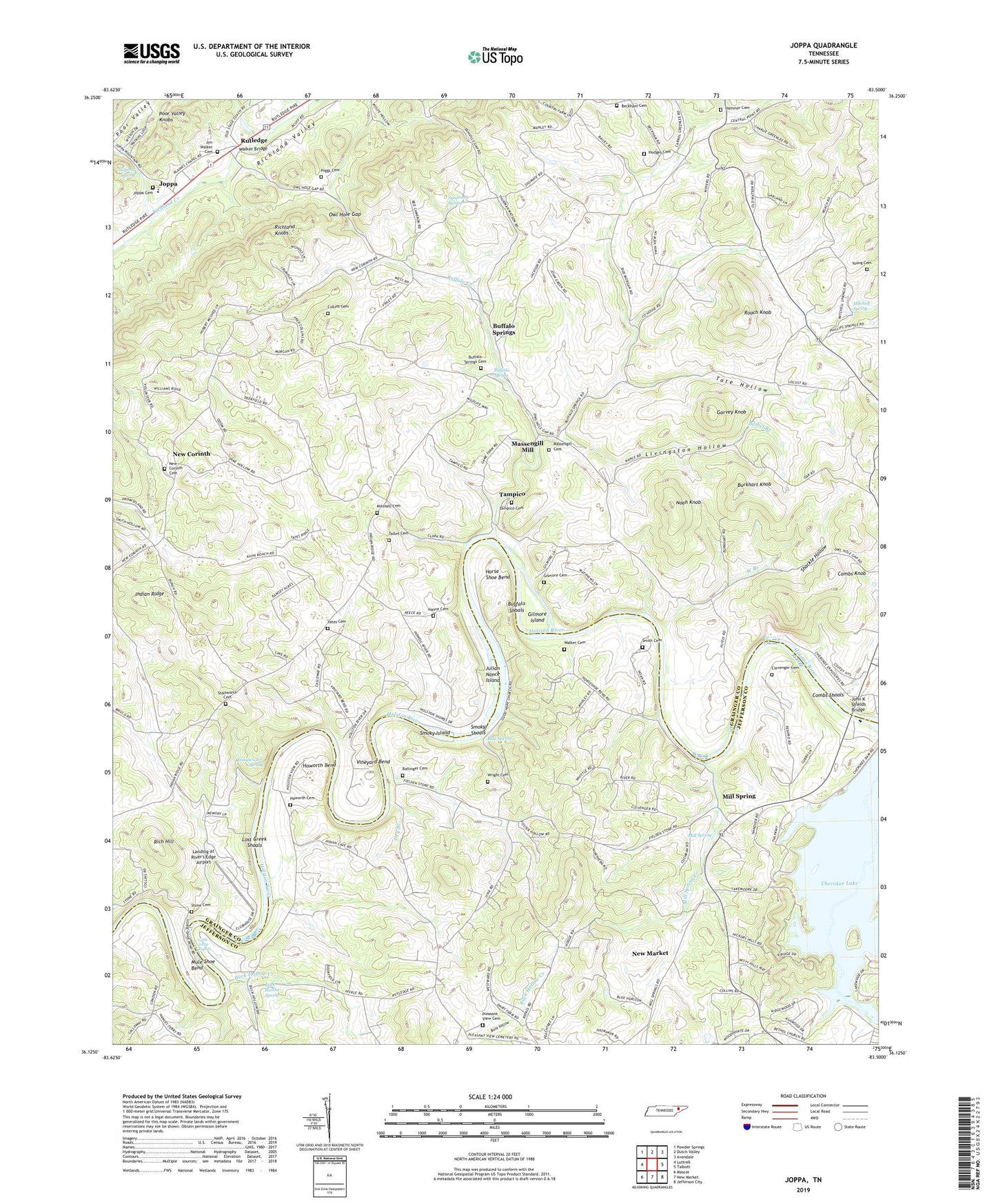
Joppa Tennessee US Topo Map
Couldn't load pickup availability
2022 topographic map quadrangle Joppa in the state of Tennessee. Scale: 1:24000. Based on the newly updated USGS 7.5' US Topo map series, this map is in the following counties: Grainger, Jefferson. The map contains contour data, water features, and other items you are used to seeing on USGS maps, but also has updated roads and other features. This is the next generation of topographic maps. Printed on high-quality waterproof paper with UV fade-resistant inks.
Quads adjacent to this one:
West: Luttrell
Northwest: Powder Springs
North: Dutch Valley
Northeast: Avondale
East: Talbott
Southeast: Jefferson City
South: New Market
Southwest: Mascot
This map covers the same area as the classic USGS quad with code o36083b5.
Contains the following named places: Agreeable, Ballinger Cemetery, Beckham Cemetery, Bethel Branch, Bethel Church, Blue Spring, Buck Hollow, Buck Hollow Creek, Buck Hollow Spring, Buffalo Church, Buffalo Creek, Buffalo Hollow, Buffalo School, Buffalo Shoals, Buffalo Spring, Buffalo Springs, Buffalo Springs Cemetery, Buffalo Springs Game Farm, Buffalo Springs State Game Farm, Buffalo Springs State Hatchery, Burkhart Knob, Byrd Spring Branch, Civilian Conservation Corps Camp Number 8, Clevenger Cemetery, Collins Cemetery, Combs Cattle Farm, Combs Knob, Combs Shoals, Commissioner District 1, Commissioner District 4, Dry Branch, Dyers Ferry, Fennel Store, Fielden School, Fielden Store, Finley Store, Garvey Knob, Gilmore Cemetery, Gilmore Island, Good Hope Church, Grainger County Farm, Hammer Cemetery, Hammer School, Hammer Store, Haworth Bend, Haworth Cemetery, Higgs Branch, Higgs Cemetery, Hodges Cemetery, Horse Shoe Bend, Indian Cave, Indian Cave Ferry, Indian Cave Spring, Indian Ridge, Indian Ridge Baptist Church, Indian Ridge Cemetery, Indian Ridge School, Jefferson City Community Center, Jim Walker Cemetery, John K Shields Bridge, Joppa, Joppa Cemetery, Joppa Elementary School, Joppa United Mthodist Church, Julian Nance Island, Landing at River's Edge Airport, Little Jump Rapids, Livingston Hollow, Lost Creek Shoals, Massengill Cemetery, Massengill Mill, Mill Spring, Mill Spring Creek, Mill Spring Mill, Mill Spring School, Mill Springs Baptist Church, Miller Store, Mitchell Cemetery, Mitchell Quarry, Mitchell Spring, Mitchell Spring Church, Morgan School, Mossy Creek, Mossy Creek Beat Dock, Mule Shoe Bend, Nance Cemetery, New Corinth, New Corinth Baptist Church, New Corinth Cemetery, Noah Knob, Oars Ferry, Owl Hole Gap, Paskell Pond, Pecks Mill, Pleasant Grove Baptist Church, Pleasant View Cemetery, Poor Valley Knobs, Rich Hill, Roach Knob, Roach Store, Shackle Hollow, Smith Cemetery, Smith Ferry, Smoky Island, Smoky Shoals, Stalsworth Cemetery, Stone Cemetery, Sulphur Spring, Sycamore Spring, Talley Cemetery, Tampico, Tampico Baptist Church, Tampico Cemetery, Tate Hollow, Trogdons Ford, Vineyard Bend, Walker Bridge, Walker Cemetery, West Branch, Wright Cemetery, Yates Cemetery, Young Cemetery, ZIP Code: 37861