MyTopo
Millington Tennessee US Topo Map
Couldn't load pickup availability
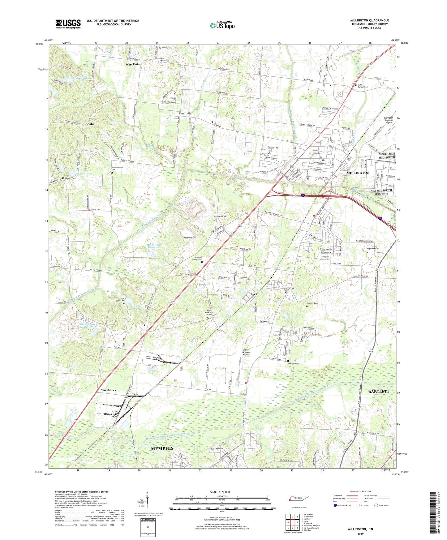
2019 topographic map quadrangle Millington in the state of Tennessee. Scale: 1:24000. Based on the newly updated USGS 7.5' US Topo map series, this map is in the following counties: Shelby. The map contains contour data, water features, and other items you are used to seeing on USGS maps, but also has updated roads and other features. This is the next generation of topographic maps. Printed on high-quality waterproof paper with UV fade-resistant inks.
Quads adjacent to this one:
West: Locke
Northwest: Pecan Point
North: Drummonds
Northeast: Munford
East: Brunswick
Southeast: Ellendale
South: Northeast Memphis
Southwest: Northwest Memphis
Contains the following named places: Aycock Park, Bear Creek, Bell Mont Church, Belmount Cemetery, Big Creek Cemetery, Big Creek Church, Big Creek Drainage Canal, Bland Farms, Campbell Chapel, Canaan Church, Charles W Baker Airport, City of Millington, Coins Store, Commissioner District 1, Cuba, E A Harrold Park, Eastwood Park, Embury Church, Embury United Methodist Church Cemetery, Faith Heritage Christian Academy, First Baptist Church of Millington, First United Methodist Church, Friendship Church, Goldsby Cemetery, Greenleaf Christian Methodist Episcopal Church, Greenleif Church, Griffin Corner, Harrold Junior High School, Jakes Creek, Johnson Lake, Johnson Lake Dam, Jones Orchard, Lighthouse Christian Academy, Little John, Little John Cemetery, Little John Missionary Baptist Church, Lucy, Lucy Baptist Church, Lucy Elementary School, Millington, Millington Branch-Shelby County Public Library, Millington Church, Millington Church of Christ, Millington Church of God, Millington City Hall, Millington Division, Millington Elementary School, Millington Fire Department Station 1, Millington Fire Department Station 2, Millington High School, Millington Memorial Stadium, Millington Middle School, Millington Post Office, Millington Presbyterian Church, Millington Sewage Treatment Plant, Millington South Park, Millington Square Shopping Center, Mission Bible Church, Mitchell Dam Number Three, Mitchell Lake Dam Number One, Mitchell Lake Number One, Mitchell Lake Number Three, Mount Olive Church, Mount Olive Methodist Church, Mount Pisgah Church, Mount Sinai Church, Noblin Cemetery, North Fork Creek, North Shelby Landfill, Northridge Woodhaven Cemetery, Oak Park, Plaza Center Shopping Center, Promiseland Church, R H Williams Dam, Remberts Cemetery, Royster Creek, Royster Creek Drainage Canal, Saint Annes Episcopal Church, Saint Williams Catholic Church, Shelby County Fire Department Station 66, Shelby County Fire Department Station 68, Sigler Cemetery, Sloanville, South School, Southside Church, Tabernacle Church, Temple Baptist Church, Temple Church, Tompkins Lake, Tompkins Lake Dam, Union Cemetery, Walsh School, Ward Memorial Cemetery, West Canaan Cemetery, West Canaan Church, West Union, West Union Cemetery, West Union Cumberland Presbyterian Church, West Union Presbyterian Church, Williams Lake, Woodlawn Terrace Academy, Woodstock, Woodstock Baptist Church, Woodstock Elementary School, Woodstock Middle School, WTNN-AM (Millington), Zion Hill Church, Zion Hill Church Cemetery, ZIP Code: 38053