MyTopo
Perryville Tennessee US Topo Map
Couldn't load pickup availability
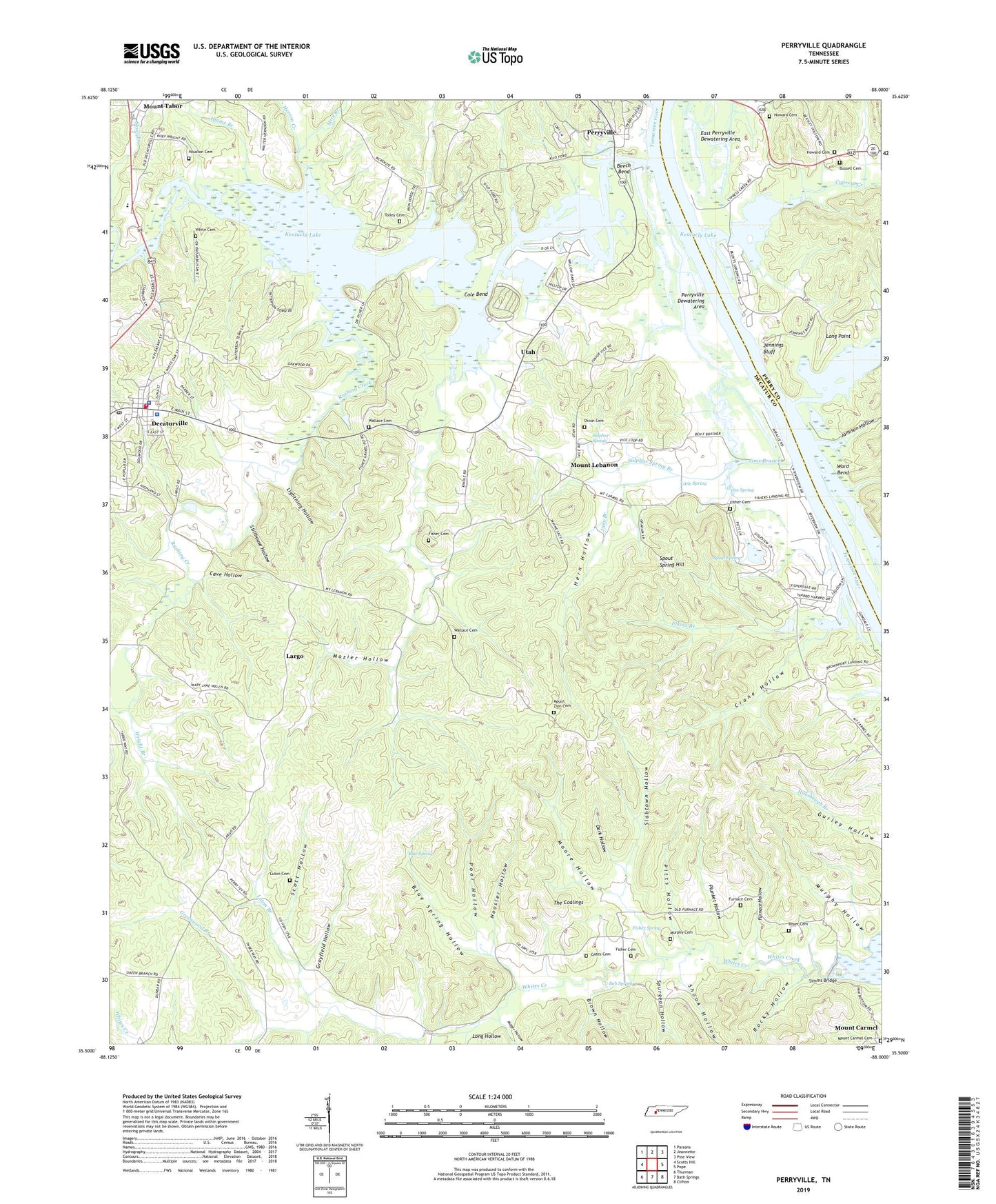
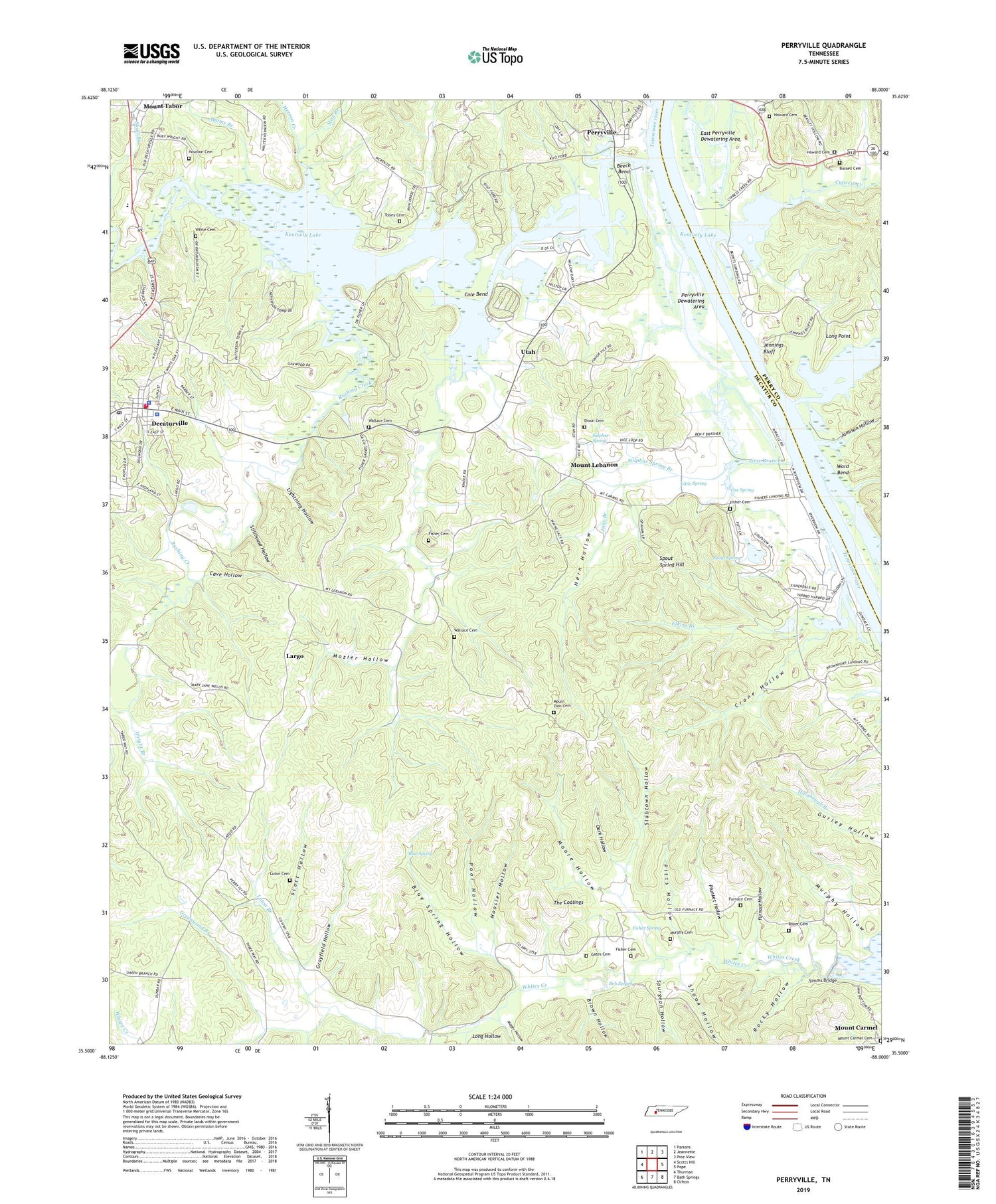
2019 topographic map quadrangle Perryville in the state of Tennessee. Scale: 1:24000. Based on the newly updated USGS 7.5' US Topo map series, this map is in the following counties: Decatur, Perry. The map contains contour data, water features, and other items you are used to seeing on USGS maps, but also has updated roads and other features. This is the next generation of topographic maps. Printed on high-quality waterproof paper with UV fade-resistant inks.
Quads adjacent to this one:
West: Scotts Hill
Northwest: Parsons
North: Jeannette
Northeast: Pine View
East: Pope
Southeast: Clifton
South: Bath Springs
Southwest: Thurman
Contains the following named places: Adams Branch, Beasley Hollow, Beech Bend, Beech Bend Recreation Area, Beech River, Beech River Landing, Blue Spring, Blue Spring Hollow, Blunts Landing, Bob Spring, Boyer Cemetery, Brown Hollow, Brownsport Furnace, Buck Branch, Bussell Cemetery, Cave Hollow, Cedar Grove Church, Cole Bend, Commissioner District 4, Crane Hollow, Crowell Branch, Cypress Creek, Cypress Creek Boat Dock, Cypress Creek School, Dark Hollow, Decatur County, Decatur County Courthouse, Decatur County Sheriff's Office, Decatur County Volunteer Fire Department Station 3, Decaturville, Decaturville Fire Department, Decaturville First Baptist Church, Decaturville High School, Decaturville Police Department, Decaturville Post Office, Dixon Cemetery, Dry Branch, East Perryville Landing, Elkins Branch, Elkins Landing, First United Methodist Church of Decaturville, Fisher Branch, Fisher Cemetery, Fisher Spring, Fishers Landing, Furnace Cemetery, Furnace Hollow, Gates Cemetery, Grayfield Hollow, Greenwood Branch, Hern Hollow, Herron Creek, Hoosier Hollow, Horseshoe Pond, Houston Cemetery, Howard Cemetery, Jamison Hollow, Jennings Bluff, Jennings Bluff Landing, Jims Branch, Largo, Largo School, Largo Trail, Lightning Hollow, Little Spring, Long Hollow, Long Point, Lost Creek, Lost Creek Dock, Luton Branch, Luton Cemetery, Mager Hollow, Marsh Creek, Marvins Bluff Landing, McKendre School, Mire Branch, Moore Hollow, Mount Carmel Cemetery, Mount Carmel Church, Mount Lebanon, Mount Lebanon Church, Mount Lebanon School, Mount Tabor, Mount Tabor Pentecostal Church, Mount Tabor School, Mount Zion Cemetery, Mount Zion Trail, Mozier Hollow, Murphy Cemetery, Murphy Hollow, Old Mill, Perryville, Perryville Dewatering Area, Perryville Ferry, Perryville First Baptist Church, Perryville Post Office, Perryville School, Pikes Peak Branch, Pitts Hollow, Plunket Hollow, Poor Hollow, Rameys Dock, Riverside High School, Rocky Hollow, Round Pond, Rushing Creek, Scott Hollow, Shook Hollow, Simms Bridge, Slabtown Hollow, Spout Spring, Spout Spring Hill, Spurgeon Hollow, Stillhouse Hollow, Sulphur Spring, Sulphur Spring Branch, Tanyard Park, The Coalings, Thwattles Landing, Tolley Cemetery, Town of Decaturville, Utah, Utah School, Vise Spring, Wallace Cemetery, Ward Bend, Wards Ferry, Webbs Landing, White Cemetery, Wright Branch, ZIP Code: 38329