MyTopo
Clifton Tennessee US Topo Map
Couldn't load pickup availability
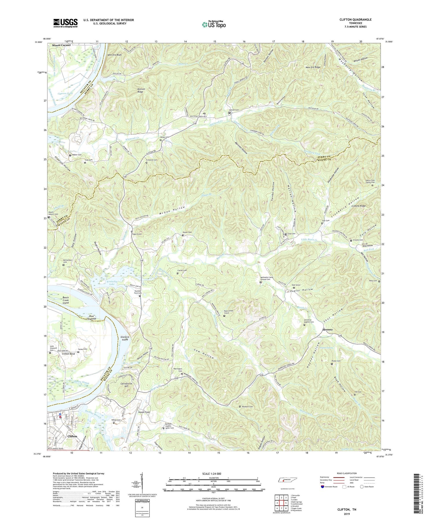
2022 topographic map quadrangle Clifton in the state of Tennessee. Scale: 1:24000. Based on the newly updated USGS 7.5' US Topo map series, this map is in the following counties: Wayne, Perry, Decatur. The map contains contour data, water features, and other items you are used to seeing on USGS maps, but also has updated roads and other features. This is the next generation of topographic maps. Printed on high-quality waterproof paper with UV fade-resistant inks.
Quads adjacent to this one:
West: Bath Springs
Northwest: Perryville
North: Pope
Northeast: Linden
East: Leatherwood
Southeast: Waynesboro
South: Eagle Creek
Southwest: Olivehill
This map covers the same area as the classic USGS quad with code o35087d8.
Contains the following named places: Anderson Hollow, Beech Creek, Beech Creek Island, Benham-Hughes-Speer Cemetery, Bost Fork, Boyd Hollow, Briley Cemetery, Buckeye Branch, Buttam Hollow, Caney Hollow, Carroll Cemetery, Carrollville, Carrollville Hill, City of Clifton, Clifton, Clifton City Park, Clifton Ferry, Clifton Police Department, Clifton Post Office, Clifton Volunteer Fire Department, Clifton-Natural Bridge Division, Commissioner District 2, Conway School, Cow Hollow, Crossno Cemetery, Crossnoe Cemetery, Culp Cemetery, Culp Hollow, Cypress Pond, Deaton Hollow, Flippo Branch, Flippo Grave, Floyd Hollow, Frank Hughes School, Glenkirk Island, Glenkirk Landing, Haggard Hollow, Hassell Field, Haynes Hollow, Haynes Spring, Haynes Spring School, Helton Cemetery, Henry Culp Family Plot, Hill Cemetery, Howell Cemetery, Howell Fork, Kittrell Landing, Kittrell Ridge, Kyle Grave, Lane Branch, Lego, Lego Landing, Lego School, Lineberry Fork, Lineberry Hollow, Little Beech Creek, Little Beech School, Lone Chestnut Cemetery, McGee Hollow, Methodist Camp Ground Cemetery, Mill Hollow, Mill Hollow Branch, Mooney, Morrison Creek, Morrison Hollow, Mount Auburn Cemetery, Mount Auburn Church, New Bethlehem Church, New Era Bluff, New Era Ridge, New Zion Church, Newborn Cemetery, Nunnley Ford Cemetery, Old Warrington Cemetery, Parker Branch, Penny Slough, Penny Slough Landing, Peters Landing, Peters Landing Post Office, Pevahouse Hollow, Poplar Hollow, Prater Branch, Prater Cemetery, Prater Chapel, Primitive Baptist Cemetery, Renfro Hollow, Richardson Cemetery, Riley Cemetery, Riley Hollow, Rocky Point School, Ross Creek, Russ Towhead, Ryan Childs Grave, Sewell Branch, Short Creek, Short Creek Church, Shut Hollow, Steele Cemetery, Tate Hollow, Tucker Cemetery, Tune Hollow, Turnbo Hollow, Walker Cemetery, Warren Hollow, Whiteoak Church, Whiteoak School, Wilson Hollow, Zion Cemetery, ZIP Code: 38425